Franklin County, North Carolina facts for kids
Quick facts for kids
Franklin County
|
|||
|---|---|---|---|

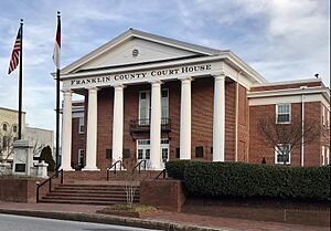
Franklin County Courthouse in Louisburg
|
|||
|
|||
| Motto(s):
"Leges Juraque Vindicamus" (Latin)
(We Defend Laws and Justice) "A Research Triangle Region Community" |
|||

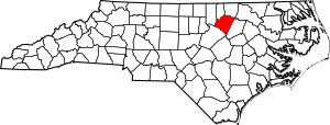
Location within the U.S. state of North Carolina
|
|||
 North Carolina's location within the U.S. |
|||
| Country | |||
| State | |||
| Founded | 1779 | ||
| Named for | Benjamin Franklin | ||
| Seat | Louisburg | ||
| Largest community | Louisburg | ||
| Area | |||
| • Total | 494.57 sq mi (1,280.9 km2) | ||
| • Land | 491.80 sq mi (1,273.8 km2) | ||
| • Water | 2.77 sq mi (7.2 km2) 0.56% | ||
| Population
(2020)
|
|||
| • Total | 68,573 | ||
| • Estimate
(2023)
|
77,001 |
||
| • Density | 138.6518/sq mi (53.5337/km2) | ||
| Time zone | UTC−5 (Eastern) | ||
| • Summer (DST) | UTC−4 (EDT) | ||
| Congressional district | 1st | ||
Franklin County is a county in the state of North Carolina. A county is like a smaller area within a state. In 2020, about 68,573 people lived here. The main town, or county seat, is Louisburg. Franklin County is part of a larger area called the Research Triangle, which includes the cities of Raleigh and Cary. This whole area had about 2.3 million people in 2023.
History
Franklin County was created in 1779. It was formed from the southern part of an older county called Bute County. The county is named after Benjamin Franklin, a famous American inventor and statesman. It is also part of the Research Triangle area.
How Franklin County Was Formed
Counties in North Carolina were created over many years. Here are some key steps that led to Franklin County:
- 1764 – Bute County was formed.
- 1779 – Franklin County was formed from Bute County.
- 1787 – Franklin County gained some land from Wake County.
- 1875 – Franklin County gained more land from Granville County.
- 1881 – Franklin County gave up some land to help create Vance County.
School Changes
In the 1960s, schools in Franklin County went through a big change called desegregation. This meant that schools, which used to be separate for different races, became open to all students. This change was sometimes difficult. To remember this important time, a project at Louisburg College collected stories from people who lived through it.
County Song
Franklin County has its own special song! It was chosen in 1929 by a local history group. The words were written by Fred U. Wolfe, who was an agriculture teacher. The song is sung to the tune of "O Christmas Tree." It was used in the county's 200th birthday celebrations in 1979.
With loyalty we sing thy praise,
Glory to thy honored name!
Our voices loud in tribute raise,
Making truth thy pow'r proclaim.
Thy past is marked with vict'ry bold;
Thy deeds today can ne'er be told,
And heroes brave shall e'er uphold
Franklin's name forevermore.
We love thy rich and fruitful soil,
Wood, and stream, and thriving town.
We love the gift of daily toil,
Making men of true renown.
Thy church and school shall ever stand
To drive the darkness from our land—
A true and loyal, valiant band,
Sons of Franklin evermore.
A shrine of promise, pow'r and truth,
Lasting righteousness and peace,
A land of hope for toiling youth,
Yielding songs that never cease.
Let ev'ry son and daughter stay
The hand of vice that brings decay.
When duty's voice we shall obey,
Franklin's name shall live for aye.
Geography
Franklin County covers about 494.57 square miles. Most of this area is land, about 491.80 square miles. The rest, about 2.77 square miles, is water.
Nature Areas
You can find these protected natural areas in Franklin County:
- Sandy Creek Game Land (part)
- Shocco Creek Game Land (part)
- V.E. and Lydia H. Owens Recreational Park at Bull Creek
Rivers and Lakes
Many important water bodies flow through or are located in Franklin County:
- Buffalo Creek
- Camping Creek
- Crooked Creek
- Fishing Creek
- Lake Royale
- Little River
- Sandy Creek
- Shocco Creek
- Tar River
Neighboring Counties
Franklin County shares borders with these counties:
- Warren County – to the northeast
- Vance County – to the north
- Granville County – to the northwest
- Wake County – to the southwest
- Johnston County – to the south
- Nash County – to the east
Main Roads

 Future I-87
 US 1
US 1 US 1A
US 1A US 64
US 64 US 401
 NC 39
NC 39 NC 56
NC 56 NC 58
NC 58 NC 96
NC 96 NC 97
NC 97 NC 98
NC 98 NC 561
 NC 581
Other Important Places
- Triangle North Executive Airport is an airport located in the county.
People and Population
| Historical population | |||
|---|---|---|---|
| Census | Pop. | %± | |
| 1790 | 7,502 | — | |
| 1800 | 8,529 | 13.7% | |
| 1810 | 10,166 | 19.2% | |
| 1820 | 9,741 | −4.2% | |
| 1830 | 10,665 | 9.5% | |
| 1840 | 10,980 | 3.0% | |
| 1850 | 11,713 | 6.7% | |
| 1860 | 14,107 | 20.4% | |
| 1870 | 14,134 | 0.2% | |
| 1880 | 20,829 | 47.4% | |
| 1890 | 21,090 | 1.3% | |
| 1900 | 25,116 | 19.1% | |
| 1910 | 24,692 | −1.7% | |
| 1920 | 26,667 | 8.0% | |
| 1930 | 29,456 | 10.5% | |
| 1940 | 30,382 | 3.1% | |
| 1950 | 31,341 | 3.2% | |
| 1960 | 28,755 | −8.3% | |
| 1970 | 26,820 | −6.7% | |
| 1980 | 30,055 | 12.1% | |
| 1990 | 36,414 | 21.2% | |
| 2000 | 47,260 | 29.8% | |
| 2010 | 60,619 | 28.3% | |
| 2020 | 68,573 | 13.1% | |
| 2023 (est.) | 77,001 | 27.0% | |
| U.S. Decennial Census 1790–1960 1900–1990 1990–2000 2010 2020 |
|||
2020 Census Information
In 2020, the census showed that 68,573 people lived in Franklin County. There were 26,720 households, which are groups of people living together in one home.
Here's a look at the different groups of people living in Franklin County in 2020:
| Group | Number | Percentage |
|---|---|---|
| White (not Hispanic) | 42,285 | 61.66% |
| Black or African American (not Hispanic) | 15,785 | 23.02% |
| Native American | 259 | 0.38% |
| Asian | 452 | 0.66% |
| Pacific Islander | 17 | 0.02% |
| Other/Mixed | 2,813 | 4.1% |
| Hispanic or Latino | 6,962 | 10.15% |
2010 Census Information
In 2010, 60,619 people lived in Franklin County. About 66% of the people were White, and about 26.7% were Black or African American. About 7.9% of the population identified as Hispanic or Latino.
The average age of people in the county was about 39.1 years old.
Economy
Franklin County's economy and population are growing. This is partly because it is close to Wake County, which is also growing fast.
Education
Franklin County Schools runs 16 schools in the county. These schools teach students from pre-kindergarten all the way through twelfth grade. There are four high schools, four middle schools, and eight elementary schools.
Franklin County also has two colleges:
- Louisburg College: A two-year college.
- Vance-Granville Community College: Has a campus here.
There are also charter schools like Youngsville Academy, which opened in 2015, and Wake Preparatory Academy, which opened in 2022. Charter schools are public schools that have more freedom in how they operate.
Communities
Towns
These are the main towns in Franklin County:
- Bunn
- Franklinton
- Louisburg (This is the county seat and the biggest town.)
- Youngsville
Census-designated places
These are areas that are like towns but are not officially incorporated as towns:
Unincorporated communities
These are smaller communities that are not part of any town:
- Alert
- Epsom
- Five Points
- Gold Sand
- Gupton
- Halls Crossroads
- Harris Crossroads
- Hickory Rock
- Ingleside
- Katesville
- Kearney
- Justice
- Laurel Mill
- Mapleville
- Margaret
- Mitchiners Crossroads
- Moulton
- Needmore
- New Hope
- Oswego
- Pearces
- Pilot
- Pine Ridge
- Pocomoke
- Raynor
- Riley
- Rocky Ford
- Royal
- Schloss
- Seven Paths
- Stallings Crossroads
- Sutton
- White Level
- Wilders Corner
- Wood
Townships
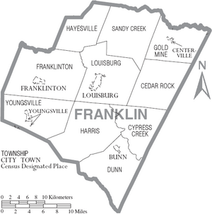
Townships are smaller divisions of a county, often used for things like voting or land records:
- Cedar Rock
- Cypress Creek
- Dunn
- Franklinton
- Gold Mine
- Harris
- Hayesville
- Louisburg
- Sandy Creek
- Youngsville
See also
 In Spanish: Condado de Franklin (Carolina del Norte) para niños
 | Jessica Watkins |
 | Robert Henry Lawrence Jr. |
 | Mae Jemison |
 | Sian Proctor |
 | Guion Bluford |


