North Carolina Highway 581 facts for kids
Quick facts for kids
NC 581 |
||||
|---|---|---|---|---|

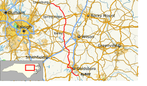
Route of NC 581 highlighted in red
|
||||
| Route information | ||||
| Maintained by NCDOT | ||||
| Length | 72.1 mi (116.0 km) | |||
| Existed | 1933–present | |||
| Major junctions | ||||
| South end | ||||
|
||||
| North end | ||||
| Location | ||||
| Counties: | Wayne, Wilson, Nash, Franklin | |||
| Highway system | ||||
North Carolina Highway System
|
||||
North Carolina Highway 581 (NC 581) is an important road in North Carolina, USA. It helps people travel from Goldsboro in the south all the way to Louisburg in the north. This highway connects many smaller towns and communities along its path. It's about 72 miles long, which is like driving from one end of a state to the other!
Contents
What Makes NC 581 Special?
Some parts of NC 581 have special names to honor important people. These names help us remember their contributions.
Honoring People and Places
- George Washington Finch Bridge – This is the official name for the bridge where NC 581 goes over US 264 in Nash County. It was named in 1978.
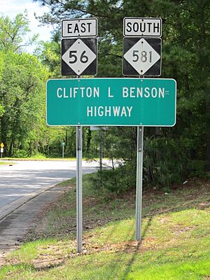
- Clifton L Benson Highway – This name is for the part of NC 581 that runs together with NC 56. It stretches from Mapleville to Louisburg and was named in 1972.
The Story of NC 581
Highways often change over time, and NC 581 has an interesting history of growing and changing its path.
How NC 581 Grew Over Time
NC 581 was first created in 1933. Back then, it was a much shorter road. It only went from Bailey north to Spring Hope.
Over the years, the highway was extended many times:
- 1937: NC 581 was made longer, stretching south to connect with US 301 near Lucama.
- 1941: It was extended north to meet NC 56 in Mapleville.
- 1950: The highway grew even more! It was extended south to US 70 and then east into downtown Goldsboro.
- 1982: NC 581 was extended north from Mapleville, sharing its path with NC 56, all the way to its current end in Louisburg.
Changes in Goldsboro and Bailey
In 1998, the route of NC 581 in Goldsboro was changed. It was moved to run along US 13/US 117 for a bit, then went southeast to its current end at NC 111. In 2008, it was moved again onto a new, faster road (a freeway extension) with US 117. This helped traffic flow better.
A big change happened in Bailey in 2015. NC 581 was rerouted to follow a different path through town. This new path uses Main, Benson, and Deans Streets. The reason for this change was safety. The old route had a very low railroad bridge that was only about 8.6 feet tall. Many vehicles, including a school activity bus, had trouble with this low bridge. To keep everyone safe, the highway was moved to avoid this dangerous spot. Now, the old section of Sanford Street is only for smaller vehicles, and big trucks are not allowed there.
Special Routes Connected to NC 581
Sometimes, highways have "special routes" that help with traffic or avoid certain areas.
Bailey Truck Route (No Longer Used)
| Location: | Bailey, North Carolina |
|---|---|
| Length: | 0.4 mi (0.6 km) |
Before 2015, there was a special route called North Carolina Highway 581 Truck in Bailey. This route was a detour for large trucks and tall vehicles. It helped them avoid the low railroad bridge that was on the main NC 581 highway. Trucks would use Main, Benson, and Deans Streets instead. However, in 2015, the main NC 581 was permanently moved to this safer route, so the separate "truck route" was no longer needed.
 | George Robert Carruthers |
 | Patricia Bath |
 | Jan Ernst Matzeliger |
 | Alexander Miles |


