Wilson County, North Carolina facts for kids
Quick facts for kids
Wilson County
|
|||
|---|---|---|---|

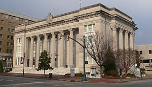
Wilson County Courthouse
|
|||
|
|||

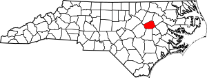
Location within the U.S. state of North Carolina
|
|||
 North Carolina's location within the U.S. |
|||
| Country | |||
| State | |||
| Founded | 1855 | ||
| Named for | Col. Louis D. Wilson | ||
| Seat | Wilson | ||
| Largest community | Wilson | ||
| Area | |||
| • Total | 373.10 sq mi (966.3 km2) | ||
| • Land | 367.57 sq mi (952.0 km2) | ||
| • Water | 5.53 sq mi (14.3 km2) 1.48% | ||
| Population
(2020)
|
|||
| • Total | 78,784 | ||
| • Estimate
(2023)
|
78,970 |
||
| • Density | 211.161/sq mi (81.5295/km2) | ||
| Time zone | UTC−5 (Eastern) | ||
| • Summer (DST) | UTC−4 (EDT) | ||
| ZIP Codes |
27542, 27557, 27803, 27807, 27813, 27822, 27829, 27830, 27851, 27852, 27873, 27878, 27880, 27883, 27888, 27893, 27895, 27896
|
||
| Area code | 252 | ||
| Congressional district | 1st | ||
Wilson County is a place in the state of North Carolina, United States. It's like a big neighborhood with its own local government. In 2020, about 78,784 people lived here. The main town and county seat is Wilson. This county is part of a larger area that includes nearby towns like Rocky Mount.
Contents
History of Wilson County
Wilson County was created on February 13, 1855. It was formed from parts of four other counties: Edgecombe, Johnston, Nash, and Wayne.
The county was named after Colonel Louis Dicken Wilson. He was a soldier and also served in the state senate. Sadly, he passed away from yellow fever during the Mexican–American War.
From 1951 to 1960, the Wilson Speedway hosted 12 NASCAR Cup Series races. This dirt track was a popular spot for racing fans for many years.
Geography of Wilson County
Wilson County covers about 373 square miles. Most of this area is land, with a small part being water.
Important Water Bodies
- Black Creek
- Buckhorn Reservoir
- Contentnea Creek
- Lake Wilson
- Silver Lake
- Wiggins Mill Reservoir
Neighboring Counties
Wilson County shares its borders with several other counties:
- Nash County – to the north
- Edgecombe County – to the northeast
- Pitt County – to the east
- Greene County – to the southeast
- Wayne County – to the south
- Johnston County – to the southwest
Main Roads and Transportation
 I-95
I-95


 I-587 / Future I-587
 I-795
I-795 US 117
 US 264


 US 264 Alt.
 US 301
 NC 42
NC 42 NC 58
NC 58 NC 111
 NC 222
 NC 581
Key Facilities
- Amtrak Thruway (Wilson Station)
- Wilson Industrial Air Center (an airport)
- Wilson Station (train station)
People of Wilson County
| Historical population | |||
|---|---|---|---|
| Census | Pop. | %± | |
| 1860 | 9,720 | — | |
| 1870 | 12,258 | 26.1% | |
| 1880 | 16,064 | 31.0% | |
| 1890 | 18,644 | 16.1% | |
| 1900 | 23,596 | 26.6% | |
| 1910 | 28,269 | 19.8% | |
| 1920 | 36,813 | 30.2% | |
| 1930 | 44,914 | 22.0% | |
| 1940 | 50,219 | 11.8% | |
| 1950 | 54,506 | 8.5% | |
| 1960 | 57,716 | 5.9% | |
| 1970 | 57,486 | −0.4% | |
| 1980 | 63,132 | 9.8% | |
| 1990 | 66,061 | 4.6% | |
| 2000 | 73,814 | 11.7% | |
| 2010 | 81,234 | 10.1% | |
| 2020 | 78,784 | −3.0% | |
| 2023 (est.) | 78,970 | −2.8% | |
| U.S. Decennial Census 1790–1960 1900–1990 1990–2000 2010 2020 |
|||
In 2020, the county had 78,784 people. There were over 32,000 households. About 25% of the people living in Wilson County were under 18 years old. The average age of people in the county was 36 years.
Diversity in Wilson County
Wilson County is home to people from many different backgrounds. Here's a look at the main groups:
| Group | Number | Percentage |
|---|---|---|
| White (not Hispanic) | 36,106 | 45.83% |
| Black or African American (not Hispanic) | 29,842 | 37.88% |
| Native American | 239 | 0.3% |
| Asian | 900 | 1.14% |
| Pacific Islander | 10 | 0.01% |
| Other/Mixed | 2,663 | 3.38% |
| Hispanic or Latino | 9,024 | 11.45% |
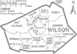
Communities in Wilson County
City
- Wilson (This is the largest town and where the county government is located.)
Towns
- Black Creek
- Elm City
- Kenly (part of this town is in Wilson County)
- Lucama
- Saratoga
- Sims
- Stantonsburg
- Sharpsburg (part of this town is in Wilson County)
Townships
These are smaller areas within the county, often including rural parts:
- Black Creek
- Cross Roads
- Gardners
- Old Fields
- Saratoga
- Springhill
- Stantonsburg
- Taylors
- Toisnot
- Wilson
Unincorporated Communities
These are smaller places that are not officially part of a city or town:
- Montclair
- New Hope
- Rock Ridge
- Lamms Crossroads
Images for kids
See also
 In Spanish: Condado de Wilson (Carolina del Norte) para niños
 | George Robert Carruthers |
 | Patricia Bath |
 | Jan Ernst Matzeliger |
 | Alexander Miles |


