Greene County, North Carolina facts for kids
Quick facts for kids
Greene County
|
|||||
|---|---|---|---|---|---|

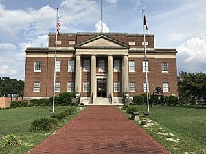
Greene County Courthouse in Snow Hill
|
|||||
|
|||||
| Motto(s):
"A place to grow. The way to live."
|
|||||

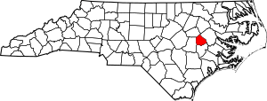
Location within the U.S. state of North Carolina
|
|||||
 North Carolina's location within the U.S. |
|||||
| Country | |||||
| State | |||||
| Founded | 1799 | ||||
| Named for | Nathanael Greene | ||||
| Seat | Snow Hill | ||||
| Largest community | Snow Hill | ||||
| Area | |||||
| • Total | 267.21 sq mi (692.1 km2) | ||||
| • Land | 266.73 sq mi (690.8 km2) | ||||
| • Water | 0.48 sq mi (1.2 km2) 0.18% | ||||
| Population
(2020)
|
|||||
| • Total | 20,451 | ||||
| • Estimate
(2023)
|
20,530 | ||||
| • Density | 76.67/sq mi (29.60/km2) | ||||
| Time zone | UTC−5 (Eastern) | ||||
| • Summer (DST) | UTC−4 (EDT) | ||||
| Congressional district | 1st | ||||
Greene County is a county in North Carolina, a state in the United States. In 2020, about 20,451 people lived here. The main town and county seat is Snow Hill.
Contents
History of Greene County
Greene County was first settled around 1710 by people moving from other states like Maryland and Virginia, and from other parts of North Carolina. This land was given to settlers by King Charles II of England in 1663.
The Tuscarora Indians originally lived in this area. They fought with the new settlers in a conflict known as the Tuscarora War. A major battle happened from March 20-23, 1713, near what is now Snow Hill. A fighting group from South Carolina and Yamasee Indians, led by Colonel Murice Moore, defeated the Tuscarora, led by Chief Hancock. This battle, at Fort Neoheroka, was the last big fight of the war.
In 1758, the area that is now Greene and Lenoir Counties was separated from Johnston County. It was named Dobbs after the Royal Governor. In 1791, Greene County was officially formed from the northern part of Dobbs County. It was first called Glasgow County, named after James Glasgow, who was North Carolina's Secretary of State from 1777 to 1798.
However, in 1799, James Glasgow was involved in a scandal about military land grants. He had to resign and leave the state. Because of this, Glasgow County was renamed Greene County. It was named to honor Nathanael Greene, a very important general who worked closely with General George Washington during the American Revolution.
The county seat, Snow Hill, is the biggest town and main business center in Greene County. The town got its name from the white sandy banks of the nearby Contentnea Creek.
Earlier Greene County
The Greene County we know today is actually the second county in North Carolina with that name. The first Greene County was also named after Nathanael Greene. It was created in 1783 in what was then the western part of North Carolina. This area later became part of the Southwest Territory (from 1790–1796) and then the State of Tennessee (after 1796). So, the first Greene County in North Carolina is now Greene County, Tennessee.
Geography
Greene County covers about 267.21 square miles. Most of this area, about 266.73 square miles, is land. Only a small part, about 0.48 square miles (0.2%), is water.
Protected Areas
- Contentnea Creek Hunting Preserve
- Oak Hill Preserve
Major Water Bodies
- Contentnea Creek
- Middle Swamp
- Nahunta Swamp
- Reedy Branch
- Sandy Run
- Turnage Millpond
- Wheat Swamp
Neighboring Counties
Greene County shares borders with these other counties:
- Pitt County – to the east-northeast
- Wilson County – to the northwest
- Lenoir County – to the south
- Wayne County – to the west
Main Roads
 I-587
I-587 US 13
US 13 US 258
 US 264


 US 264 Alt.
 NC 58
NC 58 NC 91
NC 91 NC 121
 NC 123
 NC 903
Population Information
| Historical population | |||
|---|---|---|---|
| Census | Pop. | %± | |
| 1800 | 4,218 | — | |
| 1810 | 4,867 | 15.4% | |
| 1820 | 4,533 | −6.9% | |
| 1830 | 6,413 | 41.5% | |
| 1840 | 6,595 | 2.8% | |
| 1850 | 6,619 | 0.4% | |
| 1860 | 7,925 | 19.7% | |
| 1870 | 8,687 | 9.6% | |
| 1880 | 10,037 | 15.5% | |
| 1890 | 10,039 | 0.0% | |
| 1900 | 12,038 | 19.9% | |
| 1910 | 13,083 | 8.7% | |
| 1920 | 16,212 | 23.9% | |
| 1930 | 18,656 | 15.1% | |
| 1940 | 18,548 | −0.6% | |
| 1950 | 18,024 | −2.8% | |
| 1960 | 16,741 | −7.1% | |
| 1970 | 14,967 | −10.6% | |
| 1980 | 16,117 | 7.7% | |
| 1990 | 15,384 | −4.5% | |
| 2000 | 18,974 | 23.3% | |
| 2010 | 21,362 | 12.6% | |
| 2020 | 20,451 | −4.3% | |
| 2023 (est.) | 20,530 | −3.9% | |
| U.S. Decennial Census 1790–1960 1900–1990 1990–2000 2010 2020 |
|||
2020 Census Details
| Group | Number of People | Percentage |
|---|---|---|
| White (not Hispanic) | 9,644 | 47.16% |
| Black or African American (not Hispanic) | 7,206 | 35.24% |
| Native American | 95 | 0.46% |
| Asian | 37 | 0.18% |
| Other/Mixed | 533 | 2.61% |
| Hispanic or Latino | 2,936 | 14.36% |
According to the 2020 census, there were 20,451 people living in Greene County. There were 7,164 households and 4,750 families.
Economy
The state of North Carolina considers Greene County to be an area that needs economic help. On average, a person living in Greene County earns about $36,700 per year.
Education
Schools in Greene County are managed by the Greene County Public School system. There are five schools:
- Greene Central High School
- Greene Early College High School
- Greene County Middle School
- Snow Hill Primary School
- West Greene Elementary School
For higher education, students can attend nearby East Carolina University. There are also community colleges in Goldsboro, Greenville, and Kinston. One private school, Mt. Calvary Christian Academy, is also in the county.
Communities
Towns
- Hookerton
- Snow Hill (This is the county seat and the largest community.)
- Walstonburg
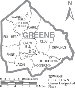
Townships
- Bull Head
- Carrs
- Hookerton
- Jason
- Olds
- Ormondsville
- Shine
- Snow Hill
- Speights Bridge
Census-designated place
Unincorporated community
See also
 In Spanish: Condado de Greene (Carolina del Norte) para niños
 | Isaac Myers |
 | D. Hamilton Jackson |
 | A. Philip Randolph |


