Lenoir County, North Carolina facts for kids
Quick facts for kids
Lenoir County
|
|||||
|---|---|---|---|---|---|

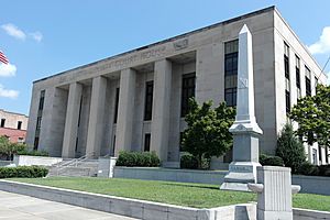
Lenoir County Courthouse in Kinston
|
|||||
|
|||||

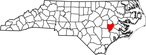
Location within the U.S. state of North Carolina
|
|||||
 North Carolina's location within the U.S. |
|||||
| Country | |||||
| State | |||||
| Founded | 1791 | ||||
| Named for | William Lenoir | ||||
| Seat | Kinston | ||||
| Largest community | Kinston | ||||
| Area | |||||
| • Total | 401.37 sq mi (1,039.5 km2) | ||||
| • Land | 399.09 sq mi (1,033.6 km2) | ||||
| • Water | 2.28 sq mi (5.9 km2) 0.57% | ||||
| Population
(2020)
|
|||||
| • Total | 55,122 | ||||
| • Estimate
(2023)
|
54,895 | ||||
| • Density | 138.12/sq mi (53.33/km2) | ||||
| Time zone | UTC−5 (Eastern) | ||||
| • Summer (DST) | UTC−4 (EDT) | ||||
| Congressional district | 3rd | ||||
Lenoir County (/lɛˈnɔːr/ LE-nor) is a county in the U.S. state of North Carolina. It is located in the eastern part of the state.
As of the 2020 census, about 55,122 people live here. The main city and county seat is Kinston. Kinston is located along the Neuse River.
Lenoir County is part of the Kinston, NC Micropolitan Statistical Area. This means Kinston is a central city for the smaller towns around it.
Contents
History of Lenoir County
Lenoir County was created in 1791. It was formed from the southern part of an older county called Dobbs County.
The county was named after William Lenoir (1751–1839). He was an important officer in the American Revolutionary War. He fought in the famous Battle of Kings Mountain.
William Lenoir was also a strong political leader. When Lenoir County was formed, he was serving as the Speaker of the North Carolina Senate.
Geography of Lenoir County
Lenoir County covers a total area of about 401 square miles. Most of this area, about 399 square miles, is land. The rest, about 2.28 square miles, is water.
Protected Natural Areas
Lenoir County has special places that are protected. These include:
Major Rivers and Creeks
Important water bodies in the county include:
- Contentnea Creek
- Neuse River
- Southwest Creek
- Wheat Swamp
Neighboring Counties
Lenoir County shares borders with several other counties:
- Greene County – to the north
- Pitt County – to the northeast
- Craven County – to the east
- Jones County – to the southeast
- Duplin County – to the southwest
- Wayne County – to the west
Main Roads and Transportation


 I-42 / Future I-42
 US 70
US 70 US 258
 NC 11
NC 11 NC 55
NC 55 NC 58
NC 58 NC 118
 NC 148
 NC 241
 NC 903
Lenoir County also has important transportation hubs:
- Amtrak Thruway (in Kinston)
- Kinston Regional Jetport (an airport)
- Global TransPark (a large business and transportation park)
- Greyhound Bus Terminal (in Kinston)
Population of Lenoir County
| Historical population | |||
|---|---|---|---|
| Census | Pop. | %± | |
| 1800 | 4,005 | — | |
| 1810 | 5,572 | 39.1% | |
| 1820 | 6,799 | 22.0% | |
| 1830 | 7,723 | 13.6% | |
| 1840 | 7,605 | −1.5% | |
| 1850 | 7,828 | 2.9% | |
| 1860 | 10,220 | 30.6% | |
| 1870 | 10,434 | 2.1% | |
| 1880 | 15,344 | 47.1% | |
| 1890 | 14,879 | −3.0% | |
| 1900 | 18,639 | 25.3% | |
| 1910 | 22,769 | 22.2% | |
| 1920 | 29,555 | 29.8% | |
| 1930 | 35,716 | 20.8% | |
| 1940 | 41,211 | 15.4% | |
| 1950 | 45,953 | 11.5% | |
| 1960 | 55,276 | 20.3% | |
| 1970 | 55,204 | −0.1% | |
| 1980 | 59,819 | 8.4% | |
| 1990 | 57,274 | −4.3% | |
| 2000 | 59,648 | 4.1% | |
| 2010 | 59,495 | −0.3% | |
| 2020 | 55,122 | −7.4% | |
| 2023 (est.) | 54,895 | −7.7% | |
| U.S. Decennial Census 1790–1960 1900–1990 1990–2000 2010 2020 |
|||
The population of Lenoir County has changed over many years. In 1800, there were just over 4,000 people. By 2020, the population grew to 55,122.
2020 Census Information
| Race | Number | Percentage |
|---|---|---|
| White (non-Hispanic) | 26,582 | 48.22% |
| Black or African American (non-Hispanic) | 22,034 | 39.97% |
| Native American | 134 | 0.24% |
| Asian | 332 | 0.6% |
| Pacific Islander | 22 | 0.04% |
| Other/Mixed | 1,653 | 3.0% |
| Hispanic or Latino | 4,365 | 7.92% |
In 2020, there were 55,122 people living in Lenoir County. These people lived in 23,148 households. About 14,863 of these were families.
Education in Lenoir County
Lenoir County offers many educational opportunities for students of all ages.
Colleges and Universities
Lenoir County has one college: Lenoir Community College. It is located in Kinston. This college is part of the North Carolina Community College System.
The college offers different types of degrees and certificates. These include programs for transferring to a four-year university. They also have programs for business, industry, health, and continuing education.
Schools for Kids
Public schools in Lenoir County are managed by the Lenoir County Public School Board. This board was formed in 1992.
There are four public high schools in the county:
- Lenoir County Early College
- North Lenoir High School
- South Lenoir High School
- Kinston High School
There are also three public middle schools:
- E.B. Frink Middle School
- Rochelle Middle School
- Woodington Middle School
The county has eight public elementary schools:
- Banks Elementary
- La Grange Elementary
- Moss Hill Elementary
- Northeast Elementary
- Northwest Elementary
- Pink Hill Elementary
- Southeast Elementary
- Southwood Elementary
Contentnea-Savannah is a special school that teaches students from kindergarten all the way to 8th grade.
Lenoir County also has private schools. These include Arendell Parrott Academy and Bethel Christian Academy. There are also two charter schools: Kinston Charter Academy and Children's Village Academy.
Libraries
The Neuse Regional Library system serves Lenoir County. It also helps people in Greene and Jones counties. The library system has eight different locations.
They offer many services, like 3D printing and borrowing books from other libraries. They also have an eLibrary where you can read books online.
Communities in Lenoir County
Lenoir County has several towns and communities.
Cities
- Kinston is the largest city and the county seat.
Towns
Townships
- Contentnea Neck
- Falling Creek
- Institute
- Kinston
- Moseley Hall
- Neuse
- Pink Hill
- Sand Hill
- Southwest
- Trent
- Vance
- Woodington
Census-Designated Places
These are areas that are like towns but are not officially incorporated.
- Deep Run
- Graingers
- Jackson Heights
Unincorporated Community
Famous People from Lenoir County
Many notable people have come from Lenoir County, including:
- Larry Beck, a professional golfer
- Jocelyn Brown, an R&B singer
- Reggie Bullock, an NBA player
- Dwight Clark, a wide receiver for the San Francisco 49ers
- Quinton Coples, an NFL defensive end
- David Christopher Hatcher, a MLB pitcher
- Malcolm Howard, a judge appointed by Ronald Reagan
- Vivian Howard, a famous American chef
- Brandon Ingram, an NBA player
- Frank Lucas, an American businessman
- Susan Owens, a judge on the Washington Supreme Court
- Maceo Parker, a saxophonist
- Melvin Parker, a drummer
- Jamie Pressley, an actor
- Frank Snepp, a journalist
- Jerry Stackhouse, an NBA player
- Donna Horton White, a professional golfer
See also
 In Spanish: Condado de Lenoir para niños
 | Frances Mary Albrier |
 | Whitney Young |
 | Muhammad Ali |


