Craven County, North Carolina facts for kids
Quick facts for kids
Craven County
|
|||
|---|---|---|---|

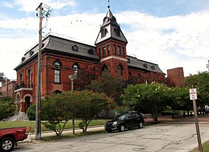
Craven County Courthouse in New Bern
|
|||
|
|||

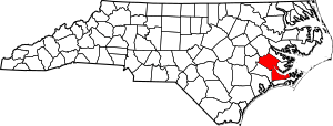
Location within the U.S. state of North Carolina
|
|||
 North Carolina's location within the U.S. |
|||
| Country | |||
| State | |||
| Founded | 1712 | ||
| Named for | William, Earl of Craven | ||
| Seat | New Bern | ||
| Largest community | New Bern | ||
| Area | |||
| • Total | 773.28 sq mi (2,002.8 km2) | ||
| • Land | 706.57 sq mi (1,830.0 km2) | ||
| • Water | 66.71 sq mi (172.8 km2) 8.63% | ||
| Population
(2020)
|
|||
| • Total | 100,720 | ||
| • Estimate
(2023)
|
102,391 | ||
| • Density | 142.55/sq mi (55.04/km2) | ||
| Time zone | UTC−5 (Eastern) | ||
| • Summer (DST) | UTC−4 (EDT) | ||
| Congressional district | 3rd | ||
Craven County is a county located in the state of North Carolina in the United States. In 2020, about 100,720 people lived here. The main town and county seat is New Bern.
The county was first created in 1705. It was called Archdale Precinct back then. In 1712, its name changed to Craven Precinct. It became a full county in 1739. The county is named after William, Earl of Craven. He was an important person who helped start the Carolina colony. Craven County is part of the New Bern area.
Contents
History of Craven County
How Craven County Started
The land that is now Craven County was first part of Bath County. In 1705, a part of Bath County was separated to form Archdale County. Around 1712, it was renamed Craven County. It was likely named after William, Lord Craven. He was one of the original owners of the Carolina colony.
Over time, parts of Craven County were used to create other counties. Carteret County was formed in 1722. New Hanover County and Johnston County were created in 1729 and 1746. The borders of Craven County changed many times until 1852.
In the early years, not many people lived in Craven County. But by 1740, the town of New Bern started to grow fast. It became the main government center. In 1746, New Bern was made the capital of the province.
In 1749, James Davis came to New Bern. He was the first printer in the colony. He started printing North Carolina's first newspaper, the North Carolina Gazette, in 1751.
Life Before the Civil War
Craven County's economy relied on farming, timber, and trade through the port of New Bern. Farmers grew many different fruits and vegetables. Cotton farming became less popular after bad weather in 1821. Fishing became more common in the late 1840s.
Many people worked as enslaved laborers in the local economy. Unlike other areas, a large number of enslaved people lived in New Bern itself. The county faced economic challenges in the 1820s. Railroads were built in the 1850s, helping trade. Even with difficulties, New Bern remained one of North Carolina's biggest cities.
Craven County During the Civil War
When North Carolina left the United States in 1861, New Bern became important for the Confederate States of America. By March 1862, many local men had joined the army. In August 1861, United States forces gained control in eastern North Carolina. This caused many families to leave New Bern for safety.
After the Civil War
The Civil War greatly affected Craven County's economy. Livestock was lost, property was damaged, and enslaved people were freed. Farming for food also suffered. However, industries like lumber and naval stores continued.
After the war, the shipping business in New Bern grew. New businesses, including a bank, were started. Many freed African Americans found work in farming, fishing, and timber. Some also went to schools set up by the government.
After 1867, big political changes happened in Craven County. More African American voters registered than white voters. They became a strong part of the Republican Party. In 1872, a part of Craven County became part of the new Pamlico County.
Geography of Craven County
Craven County covers about 773 square miles. About 706 square miles are land, and 66 square miles are water. It shares borders with several other counties. These include Pitt County and Beaufort County to the north. Pamlico County is to the east. Carteret County is to the south. Jones County is to the west, and Lenoir County is to the northwest. The Neuse River flows through Craven County.
Protected Natural Areas
Craven County has several protected natural areas. These places help keep nature safe.
- Catfish Lake South Wilderness (part)
- Croatan National Forest (part)
- Pocosin Wilderness (part)
- Pond Pine Wilderness (part)
- Sheep Ridge Wilderness
State and Local Sites
There are also state and local protected areas and sites:
- Croatan Game Land (part)
- Dover Bay Game Land
- Great Lake Recreation Site (part)
- New Bern Battlefield Site
- Neuse River Game Land (part)
- Pine Cliff Recreation Area
- Latham-Whitehurst Nature Park
- Special Secondary Nursery Areas
- Tryon Palace
Main Water Bodies
Many rivers and creeks flow through Craven County:
- Adams Creek
- Alligator Gut
- Catfish Lake
- Clubfoot Creek
- Ellis Simon Lake
- Hancock Creek
- Intracoastal Waterway
- Little Lake
- Long Lake
- Neuse River
- Trent River
- Great Lake
- Upper Broad Creek
Major Roads

 Future I-42
 US 17
US 17
 US 17 Bus. (New Bern)
 US 17 Bus. (Vanceboro)
 US 70
US 70 NC 41
NC 41 NC 43
NC 43 NC 55
NC 55 NC 101
 NC 118
 NC 306
Important Places and Transport
- Amtrak Thruway (train connections in New Bern and Havelock)
- Cherry Branch–Minnesott Beach Ferry (a ferry that goes to Pamlico County)
- Coastal Carolina Regional Airport (an airport)
- Marine Corps Air Station Cherry Point (a military airfield in Havelock)
People of Craven County
| Historical population | |||
|---|---|---|---|
| Census | Pop. | %± | |
| 1790 | 10,474 | — | |
| 1800 | 10,245 | −2.2% | |
| 1810 | 12,676 | 23.7% | |
| 1820 | 13,394 | 5.7% | |
| 1830 | 13,734 | 2.5% | |
| 1840 | 13,438 | −2.2% | |
| 1850 | 14,709 | 9.5% | |
| 1860 | 16,268 | 10.6% | |
| 1870 | 20,516 | 26.1% | |
| 1880 | 19,729 | −3.8% | |
| 1890 | 20,533 | 4.1% | |
| 1900 | 24,160 | 17.7% | |
| 1910 | 25,594 | 5.9% | |
| 1920 | 29,048 | 13.5% | |
| 1930 | 30,665 | 5.6% | |
| 1940 | 31,298 | 2.1% | |
| 1950 | 48,823 | 56.0% | |
| 1960 | 58,773 | 20.4% | |
| 1970 | 62,554 | 6.4% | |
| 1980 | 71,043 | 13.6% | |
| 1990 | 81,613 | 14.9% | |
| 2000 | 91,436 | 12.0% | |
| 2010 | 103,505 | 13.2% | |
| 2020 | 100,720 | −2.7% | |
| 2023 (est.) | 102,391 | −1.1% | |
| U.S. Decennial Census 1790–1960 1900–1990 1990–2000 2010 2020 |
|||
2020 Census Information
| Race | Number | Percentage |
|---|---|---|
| White (not Hispanic) | 64,933 | 64.47% |
| Black or African American (not Hispanic) | 19,903 | 19.76% |
| Native American | 318 | 0.32% |
| Asian | 3,059 | 3.04% |
| Pacific Islander | 150 | 0.15% |
| Other/Mixed | 5,162 | 5.13% |
| Hispanic or Latino | 7,195 | 7.14% |
In 2020, the census counted 100,720 people living in Craven County. There were 42,221 households and 28,502 families.
Communities in Craven County
Cities
Towns
- Bridgeton
- Cove City
- Dover
- River Bend
- Trent Woods
- Vanceboro
Census-Designated Places
These are areas that are like towns but are not officially incorporated.
- Brices Creek
- Cherry Branch
- Fairfield Harbour
- James City
- Neuse Forest
Other Unincorporated Communities
These are smaller communities that are not officially part of a city or town.
- Adams Creek
- Askin
- Ernul
- Fort Barnwell
- Harlowe
- Riverdale
Townships
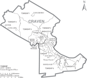
Craven County is divided into 8 townships. These are areas used for local government. They do not have specific names, just numbers:
- Township 1
- Township 2
- Township 3
- Township 5
- Township 6
- Township 7
- Township 8
- Township 9
See also
 In Spanish: Condado de Craven para niños
 | Audre Lorde |
 | John Berry Meachum |
 | Ferdinand Lee Barnett |


