Beaufort County, North Carolina facts for kids
Quick facts for kids
Beaufort County
|
|||
|---|---|---|---|

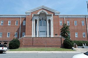
Beaufort County Courthouse
|
|||
|
|||

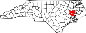
Location within the U.S. state of North Carolina
|
|||
 North Carolina's location within the U.S. |
|||
| Country | |||
| State | |||
| Founded | 1712 | ||
| Named for | Henry, Duke of Beaufort | ||
| Seat | Washington | ||
| Largest community | Washington | ||
| Area | |||
| • Total | 962.85 sq mi (2,493.8 km2) | ||
| • Land | 832.74 sq mi (2,156.8 km2) | ||
| • Water | 130.11 sq mi (337.0 km2) 13.51% | ||
| Population
(2020)
|
|||
| • Total | 44,652 | ||
| • Estimate
(2023)
|
44,481 | ||
| • Density | 53.62/sq mi (20.70/km2) | ||
| Time zone | UTC−5 (Eastern) | ||
| • Summer (DST) | UTC−4 (EDT) | ||
| Congressional district | 3rd | ||
Beaufort County (say it like BOH-fərt) is a county in the state of North Carolina. In 2020, about 44,652 people lived here. The main town and county seat is Washington.
The county started in 1705. It was first called Pamptecough Precinct. Later, in 1712, its name changed to Beaufort Precinct. It officially became Beaufort County in 1739.
Beaufort County is part of the Washington, NC area. This area is also connected to the larger Greenville-Washington, NC area.
Contents
History of Beaufort County
Beaufort County was first known as Pamptecough. Around 1712, its name changed to Beaufort. It was named after Henry Somerset, 2nd Duke of Beaufort. He was an important person who helped own and manage the Carolina colonies. These owners were called Lords Proprietor.
Geography of Beaufort County
Beaufort County covers a total area of about 963 square miles. Most of this (about 833 square miles) is land. The rest (about 130 square miles) is water. This means about 13.5% of the county is water. It is the fifth-largest county in North Carolina by total area. The Pamlico River flows right through the middle of the county.
Nature Spots and Parks
Beaufort County has several protected natural areas and historic sites. These places help keep nature safe and teach us about history.
- Goose Creek Game Land (part of it)
- Goose Creek State Park
- Historic Bath
- Van Swamp Game Lands (part of it)
- Voice of America Game Land (part of it)
Rivers and Waterways
Many important rivers and water bodies are found in Beaufort County.
Neighboring Counties
Beaufort County shares borders with several other counties:
- Martin County – to the north
- Washington County – to the northeast
- Hyde County – to the east
- Pamlico County – to the south
- Craven County – to the southwest
- Pitt County – to the west
Main Roads and Transportation
Several major highways run through Beaufort County. These roads help people travel around the area.
 US 17
US 17
 US 17 Bus.
 US 264


 US 264 Bus.
 NC 32
NC 32 NC 33
NC 33 NC 45
NC 45 NC 92
NC 92 NC 99
NC 99 NC 102
 NC 171
 NC 306
The county also has important transportation links:
- Bayview–Aurora Ferry
- Washington-Warren Field Airport
People of Beaufort County (Demographics)
| Historical population | |||
|---|---|---|---|
| Census | Pop. | %± | |
| 1790 | 5,405 | — | |
| 1800 | 6,242 | 15.5% | |
| 1810 | 7,203 | 15.4% | |
| 1820 | 9,850 | 36.7% | |
| 1830 | 10,969 | 11.4% | |
| 1840 | 12,225 | 11.5% | |
| 1850 | 13,816 | 13.0% | |
| 1860 | 14,766 | 6.9% | |
| 1870 | 13,011 | −11.9% | |
| 1880 | 17,474 | 34.3% | |
| 1890 | 21,072 | 20.6% | |
| 1900 | 26,404 | 25.3% | |
| 1910 | 30,877 | 16.9% | |
| 1920 | 31,024 | 0.5% | |
| 1930 | 35,026 | 12.9% | |
| 1940 | 36,431 | 4.0% | |
| 1950 | 37,134 | 1.9% | |
| 1960 | 36,014 | −3.0% | |
| 1970 | 35,980 | −0.1% | |
| 1980 | 40,355 | 12.2% | |
| 1990 | 42,283 | 4.8% | |
| 2000 | 44,958 | 6.3% | |
| 2010 | 47,759 | 6.2% | |
| 2020 | 44,652 | −6.5% | |
| 2023 (est.) | 44,481 | −6.9% | |
| U.S. Decennial Census 1790–1960 1900–1990 1990–2000 2010 2020 |
|||
2020 Census Information
In 2020, the census counted 44,652 people living in Beaufort County. There were about 19,701 households and 12,638 families.
Here's a look at the different groups of people living in Beaufort County in 2020:
| Group | Number | Percentage |
|---|---|---|
| White | 29,431 | 65.91% |
| Black or African American | 10,195 | 22.83% |
| Native American | 90 | 0.2% |
| Asian | 164 | 0.37% |
| Pacific Islander | 16 | 0.04% |
| Other or Mixed Race | 1,323 | 2.96% |
| Hispanic or Latino | 3,433 | 7.69% |
Family Backgrounds
In 2010, people in Beaufort County reported their family backgrounds as:
| Ancestry | Percent (2010) |
|---|---|
| English |
14.4% |
| American |
11.9% |
| German |
6.6% |
| Irish |
6.0% |
| Scottish |
2.5% |
| French |
1.6% |
| Italian |
1.5% |
Education in Beaufort County
The public schools in Beaufort County are managed by Beaufort County Schools.
Towns and Communities
City
- Washington is the main city. It is also the county seat and the largest community.
Towns
- Aurora
- Bath
- Belhaven
- Chocowinity
- Pantego
- Washington Park
Census-Designated Places
These are areas that are like towns but are not officially incorporated.
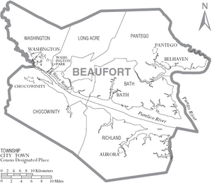
Townships
Townships are smaller divisions of the county.
- Bath
- Chocowinity
- Long Acre
- Pantego
- Richland
- Washington
Other Communities
These are smaller places that are not officially incorporated.
- Blounts Creek
- Edward
- Royal
Community Sizes
Here's a list of the communities in Beaufort County, ranked by how many people lived there in 2020. † = county seat
| Rank | Name | Type | Population (2020 census) |
|---|---|---|---|
| 1 | † Washington | City | 9,875 |
| 2 | River Road | CDP | 4,048 |
| 3 | Belhaven | Town | 1,410 |
| 4 | Chocowinity | Town | 722 |
| 5 | Aurora | Town | 455 |
| 6 | Washington Park | Town | 392 |
| 7 | Bayview | CDP | 298 |
| 8 | Bath | Town | 245 |
| 9 | Pantego | Town | 164 |
| 10 | Pinetown | CDP | 147 |
See also
 In Spanish: Condado de Beaufort (Carolina del Norte) para niños
 | Bessie Coleman |
 | Spann Watson |
 | Jill E. Brown |
 | Sherman W. White |


