Beaufort, North Carolina facts for kids
Quick facts for kids
Beaufort, North Carolina
|
|||
|---|---|---|---|

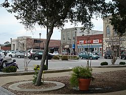
Downtown Beaufort
|
|||
|
|||

Location within the state of North Carolina
|
|||
| Country | |||
| State | |||
| County | Carteret | ||
| Named for | Henry Somerset, Duke of Beaufort | ||
| Area | |||
| • Total | 7.84 sq mi (20.31 km2) | ||
| • Land | 5.09 sq mi (13.17 km2) | ||
| • Water | 2.75 sq mi (7.13 km2) | ||
| Elevation | 3 ft (0.9 m) | ||
| Population
(2020)
|
|||
| • Total | 4,464 | ||
| • Density | 877.53/sq mi (338.82/km2) | ||
| Time zone | UTC−5 (Eastern (EST)) | ||
| • Summer (DST) | UTC−4 (EDT) | ||
| ZIP code |
28516
|
||
| Area code(s) | 252 | ||
| FIPS code | 37-04260 | ||
| GNIS feature ID | 2405222 | ||
Beaufort (pronounced BOH-fərt) is a historic town in Carteret County, North Carolina. It is the county seat, meaning it's where the local government is located. The town was founded in 1713 and officially became a town in 1723. This makes Beaufort the fourth oldest town in North Carolina.
Beaufort is sometimes confused with a city of the same name in South Carolina. The main difference is how their names are pronounced.
In 2012, Budget Travel Magazine readers voted Beaufort "America's Coolest Small Town." In 2020, about 4,464 people lived here.
Beaufort is part of North Carolina's "Inner Banks" region. It is home to several important places. These include the North Carolina Maritime Museum and the Duke University Marine Laboratory. The National Oceanic and Atmospheric Administration (NOAA) also has a center here. The Rachel Carson Reserve, a protected natural area, is also located nearby.
Contents
History of Beaufort
Beaufort has a rich history, with several places listed on the National Register of Historic Places. These include the Beaufort Historic District and the Old Burying Ground.
In June 1718, the famous pirate Blackbeard had an adventure near Beaufort. His main ship, the Queen Anne's Revenge, and another ship called Adventure got stuck in the shallow waters near what is now Beaufort Inlet. The Queen Anne's Revenge was later added to the National Register of Historic Places.
Many years later, in August 1750, a strong hurricane hit North Carolina. At least three Spanish merchant ships ran aground. One of them, the El Salvador, sank near Cape Lookout.
Geography and Location
Beaufort is located in the southern part of Carteret County. It sits on Beaufort Inlet, which is a waterway leading south to the Atlantic Ocean. To the west, the Newport River separates Beaufort from Morehead City. To the east, the North River forms another natural boundary.
U.S. Route 70 is a major road that goes through Beaufort. It connects the town to Morehead City to the west. It also goes northeast for about 31 miles (50 km) to the town of Atlantic.
The United States Census Bureau reports that Beaufort covers about 5.6 square miles (14.5 square kilometers). Most of this area is land, but about 17.75% is water.
Climate in Beaufort
Beaufort has a humid subtropical climate. This means it has long, hot summers and short, cool winters.
| Climate data for BEAUFORT MICHAEL J SMITH FLD, NC, 1991-2020 normals | |||||||||||||
|---|---|---|---|---|---|---|---|---|---|---|---|---|---|
| Month | Jan | Feb | Mar | Apr | May | Jun | Jul | Aug | Sep | Oct | Nov | Dec | Year |
| Mean maximum °F (°C) | 70.4 (21.3) |
70.0 (21.1) |
74.9 (23.8) |
79.4 (26.3) |
85.4 (29.7) |
89.8 (32.1) |
91.4 (33.0) |
89.9 (32.2) |
88.1 (31.2) |
83.3 (28.5) |
77.8 (25.4) |
72 (22) |
92.8 (33.8) |
| Mean daily maximum °F (°C) | 54.9 (12.7) |
57.1 (13.9) |
62.9 (17.2) |
70.4 (21.3) |
77.5 (25.3) |
83.6 (28.7) |
86.7 (30.4) |
85.9 (29.9) |
82.4 (28.0) |
74.5 (23.6) |
65.9 (18.8) |
58.9 (14.9) |
71.7 (22.1) |
| Daily mean °F (°C) | 46.2 (7.9) |
48.2 (9.0) |
54.0 (12.2) |
62.1 (16.7) |
70.1 (21.2) |
77.3 (25.2) |
80.6 (27.0) |
79.5 (26.4) |
75.4 (24.1) |
66.0 (18.9) |
56.5 (13.6) |
50.0 (10.0) |
63.8 (17.7) |
| Mean daily minimum °F (°C) | 37.5 (3.1) |
39.3 (4.1) |
45.0 (7.2) |
53.9 (12.2) |
62.7 (17.1) |
71.1 (21.7) |
74.4 (23.6) |
73.1 (22.8) |
68.4 (20.2) |
57.4 (14.1) |
47.1 (8.4) |
41.0 (5.0) |
55.9 (13.3) |
| Mean minimum °F (°C) | 20.4 (−6.4) |
24.8 (−4.0) |
29.4 (−1.4) |
39.8 (4.3) |
49.7 (9.8) |
60.2 (15.7) |
66 (19) |
65 (18) |
57.5 (14.2) |
42.2 (5.7) |
31.4 (−0.3) |
26.5 (−3.1) |
18.9 (−7.3) |
| Average precipitation inches (mm) | 4.17 (106) |
3.33 (85) |
3.31 (84) |
3.39 (86) |
3.94 (100) |
4.06 (103) |
5.81 (148) |
7.29 (185) |
8.46 (215) |
4.14 (105) |
3.99 (101) |
3.79 (96) |
55.68 (1,414) |
| Average precipitation days (≥ 0.01 in) | 9.6 | 10.8 | 9.8 | 9.4 | 11.0 | 11.4 | 12.7 | 13.2 | 13.0 | 9.7 | 10.0 | 10.6 | 131.2 |
| Source: NOAA | |||||||||||||
People of Beaufort
| Historical population | |||
|---|---|---|---|
| Census | Pop. | %± | |
| 1800 | 437 | — | |
| 1850 | 1,661 | — | |
| 1860 | 1,610 | −3.1% | |
| 1870 | 2,430 | 50.9% | |
| 1880 | 2,009 | −17.3% | |
| 1890 | 2,007 | −0.1% | |
| 1900 | 2,195 | 9.4% | |
| 1910 | 2,483 | 13.1% | |
| 1920 | 2,968 | 19.5% | |
| 1930 | 2,957 | −0.4% | |
| 1940 | 3,272 | 10.7% | |
| 1950 | 3,212 | −1.8% | |
| 1960 | 2,922 | −9.0% | |
| 1970 | 3,368 | 15.3% | |
| 1980 | 3,826 | 13.6% | |
| 1990 | 3,808 | −0.5% | |
| 2000 | 3,771 | −1.0% | |
| 2010 | 4,391 | 16.4% | |
| 2020 | 4,464 | 1.7% | |
| U.S. Decennial Census | |||
2020 Census Information
In 2020, Beaufort had a population of 4,464 people. There were 2,156 households and 1,071 families living in the town.
Most residents, about 80.82%, identified as White (not Hispanic). About 11.18% were Black or African American. Other groups included Asian, Native American, Pacific Islander, and people of two or more races. About 2.71% of the population was Hispanic or Latino.
2008 Census Information
In 2008, Beaufort had 4,189 people. There were 1,780 households. About 21.9% of these households had children under 18. Many households (40.3%) were married couples.
The average age of people in Beaufort was 43 years old. About 18.3% of the population was under 18. About 19.8% of residents were 65 years or older.
Education in Beaufort
Beaufort is part of the Carteret County Public Schools district.
Schools in Beaufort
- Beaufort Elementary School
- Beaufort Middle School
- Students from Beaufort attend East Carteret High School. This school is located just north of town.
- Tiller School is a local charter school.
Higher Education
- The Nicholas School of the Environment Marine Lab is a part of Duke University. It offers advanced studies in marine science.
Getting Around Beaufort
Main Roads
- US 70
- NC 101
Airport
- Michael J. Smith Field is the local airport.
Fun Things to Do in Beaufort
Beaufort hosts many fun events throughout the year. These include:
- Beaufort Music Festival
- North Carolina Maritime Museum Wooden Boat Show
- BARTA Fishing Tournament
- Beaufort Pirate Invasion
- Beaufort Wine and Food Festival
The town also has the main public library for Carteret County.
Awards and Recognitions
- On February 1, 2012, Beaufort was named "America's Coolest Small Town" by Budget Travel Magazine.
- In 2015, Beaufort was recognized as a Tree City USA by the Arbor Day Foundation. This award honors towns that care for their urban forests.
Sister Cities Around the World
Beaufort has many "sister cities" around the world. These are towns or cities that form special connections with Beaufort to promote cultural understanding. Beaufort has 19 sister cities:
 Beaufort, Victoria, Australia
 Beaufort, Haute-Garonne, France
 Beaufort, Hérault, France
 Beaufort, Isère, France
 Beaufort, Jura, France
 Beaufort, Nord, France
 Beaufort-Blavincourt, France
 Beaufort-en-Argonne, France
 Beaufort-en-Santerre, France
 Beaufort-en-Vallée, France
  Beaufort-sur-Doron, France
 Beaufort-sur-Gervanne, France
 Chapdes-Beaufort, France
 Montmorency-Beaufort, France
 Beaufort, County Kerry, Republic of Ireland
 Beaufort, Luxembourg
 Beaufort, Sabah, Malaysia
 Beaufort West, Western Cape, South Africa
 Beaufort, Wales, United Kingdom
See also
 In Spanish: Beaufort (Carolina del Norte) para niños
 | Sharif Bey |
 | Hale Woodruff |
 | Richmond Barthé |
 | Purvis Young |


