County Kerry facts for kids
Quick facts for kids
County Kerry
Contae Chiarraí
|
||
|---|---|---|
|
||
| Nickname(s):
The Kingdom
|
||
| Motto(s): | ||
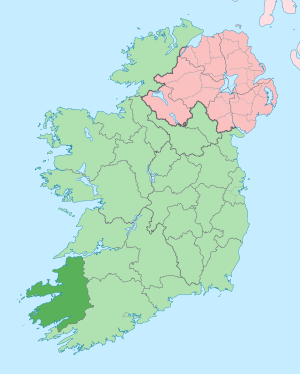
Location in Ireland
|
||
| Country | Ireland | |
| Province | Munster | |
| Region | Southern | |
| Established | c. 1300 | |
| County town | Tralee | |
| Area | ||
| • Total | 4,807 km2 (1,856 sq mi) | |
| Area rank | 5th | |
| Highest elevation | 1,039 m (3,409 ft) | |
| Population
(2022)
|
||
| • Total | 156,458 | |
| • Rank | 15th | |
| • Density | 32.548/km2 (84.299/sq mi) | |
| Time zone | UTC±0 (WET) | |
| • Summer (DST) | UTC+1 (IST) | |
| Eircode routing keys |
V23, V31, V92, V93 (primarily)
|
|
| Telephone area codes | 064, 066, 068 (primarily) | |
County Kerry (called Contae Chiarraí in Irish) is a county located on the southwest coast of Ireland. It's part of the Munster province and the Southern Region. Kerry shares borders with Limerick to the east and Cork to the south and east. The Shannon Estuary separates it from Clare to the north.
Kerry is a large county, covering about 4,807 square kilometers (1,856 square miles). As of 2022, its population was around 156,458 people. This makes it the 5th largest county in Ireland by land area and the 15th most populated. The local government for Kerry is the Kerry County Council.
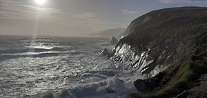
Facing the Atlantic Ocean, Kerry is Ireland's most westerly county. Its coastline is very rugged, stretching for 886 kilometers (551 miles). You'll find many bays, tall sea cliffs, sandy beaches, and small islands here. The Blaskets and the Skelligs are two of the most famous island groups. Kerry's peninsulas are quite hilly and mountainous. The MacGillycuddy's Reeks mountains on the Iveragh Peninsula rise to over 1,000 meters (3,280 feet). However, the inner parts of the county are mostly flat, with some smaller mountain ranges like the Stacks and the Mullaghareirks.
Kerry's weather is often mild and wet because of the North Atlantic Current. This warm ocean current helps special plants, like the strawberry tree and tree ferns, grow here. These plants usually don't grow so far north in Europe.
The county gets its name from the Cíarraige people, an ancient tribe who lived in this area. County Kerry became a separate region around the year 1232. For many centuries, the area was split between the Gaelic Kingdom of Desmond and the Anglo-Norman Earldom of Desmond. These two parts were finally joined together in 1606 after a big conflict called the Nine Years' War.
Kerry has two official Gaeltacht regions where the Irish language is still widely spoken. These are Gaeltacht Uíbh Ráthaigh on the Iveragh Peninsula and Gaeltacht Corca Dhuibhne on the Dingle Peninsula. In fact, the Dingle Peninsula Gaeltacht is the only one in Munster where Irish is the main language spoken by most people every day. In 2022, about 40.2% of everyone in Kerry could speak Irish. Famous writers from the Blasket Islands, like Peig Sayers, Muiris Ó Súilleabháin, and Tomás Ó Criomhthain, wrote important books in the local Munster Irish dialect.
Contents
- Exploring County Kerry's Geography
- A Look at Kerry's History
- How Kerry is Represented in Parliament
- Kerry's Rich Culture
- Sports in Kerry
- The Irish Language in Kerry
- Places to Visit in Kerry
- Media in County Kerry
- Getting Around Kerry: Transport and Services
- Famous Families and Titles from Kerry
- Notable People from County Kerry
- Images for kids
- See also
Exploring County Kerry's Geography
Kerry is the fifth largest of Ireland's 32 traditional counties by land area. It's also the fifteenth largest by population. Among the six counties in Munster, Kerry is the second largest by area. It's unique because it only borders two other counties: County Limerick to the east and County Cork to the south-east.
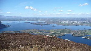
The main town of the county is Tralee. However, Killarney is where the Catholic diocese is based. Killarney is also one of Ireland's most famous places for tourists. The beautiful Lakes of Killarney are found within Killarney National Park. In the Reeks District, you'll find Carrauntoohil, which is Ireland's highest mountain at 1,039 meters (3,409 feet). The very tip of the Dingle Peninsula is the westernmost point of Ireland.
Historic Areas: Baronies
Kerry has nine historic areas called baronies. Even though they are still officially recognized, they aren't used for many everyday administrative tasks anymore.
- Clanmaurice – Clann Mhuiris
- Corkaguiny – Corca Dhuibhne
- Dunkerron North – Dún Ciaráin Thuaidh
- Dunkerron South – Dún Ciaráin Theas
- Glanarought – Gleann na Ruachtaí
- Iraghticonnor – Oireacht Uí Chonchúir
- Iveragh (Peninsula) – Uíbh Ráthach
- Magunihy – Maigh gCoinchinn
- Trughanacmy – Triúcha an Aicme
Kerry's Biggest Towns
Here are the most populated towns in County Kerry, based on the 2022 census:
| Rank | Town | Population (2022 census) |
|---|---|---|
| 1 | Tralee | 26,079 |
| 2 | Killarney | 14,412 |
| 3 | Listowel | 4,794 |
| 4 | Kenmare | 2,566 |
| 5 | Castleisland | 2,564 |
| 6 | Killorglin | 2,163 |
| 7 | Dingle | 1,671 |
| 8 | Ballybunion | 1,618 |
| 9 | Cahersiveen | 1,297 |
| 10 | Milltown | 1,118 |
Mountains, Islands, and Rivers
County Kerry faces the Atlantic Ocean. It has many long, narrow pieces of land sticking out into the sea, called peninsulas. The main ones are the Dingle Peninsula, the Iveragh Peninsula, and the Beara Peninsula. The River Shannon forms Kerry's northern border.
Kerry is one of the most mountainous parts of Ireland. Its three highest mountains are Carrauntoohil, Beenkeragh, and Caher. All of these are part of the MacGillycuddy's Reeks mountain range.
Close to the coast, you'll find several islands. These include the Blasket Islands, Valentia Island, and the Skelligs. Skellig Michael is a World Heritage Site. It's famous for an old medieval monastery built right onto the island's cliffs.
The very westernmost point of Ireland is Dunmore Head on the Dingle Peninsula. If you include islands, it's Tearaght Island, which is part of the Blaskets. The most westerly place in Ireland where people live is Dún Chaoin, also on the Dingle Peninsula. Several rivers flow through Kerry into the Atlantic, such as the River Feale, the River Laune, and the Roughty River.
Kerry's Climate
The North Atlantic Current, which is part of the Gulf Stream, flows past Kerry. This makes the temperatures milder than you might expect for a place so far north. Thanks to this, special subtropical plants like the strawberry tree and tree ferns can grow here. These plants are not usually found in northern Europe.
Because of its mountains and the winds coming from the southwest, Kerry gets a lot of rainfall. It's one of the wettest regions in Ireland. In 1993, the Irish record for rainfall in one day was set at Cloore Lake in Kerry, with 243.5 mm (9.59 inches) of rain.
A Look at Kerry's History
The name Kerry (Ciarraí in Irish) means "the people of Ciar." Ciar was the name of an old Gaelic tribe who lived in this area. The county is often nicknamed the Kingdom.
Early History and Norman Influence
In the 15th century, much of what is now County Kerry was part of the County Desmond. This area was controlled by the FitzGeralds, a powerful Norman-Irish family.
Conflicts and Changes
In 1580, during the Second Desmond Rebellion, a sad event called the Siege of Smerwick happened. A force of 600 Italian, Spanish, and Irish fighters landed at Dún an Óir near Ard na Caithne (Smerwick). English forces surrounded them, and many were killed.
In 1588, the famous Spanish Armada in Ireland fleet was returning to Spain during a big storm. Many ships tried to find shelter near the Blasket Islands, and some were wrecked there.
Kerry was also a battleground during the Nine Years' War. The O'Sullivan Beare clan joined the rebellion. In 1602, their castle at Dunboy was attacked and captured by English soldiers. To escape, Donal O'Sullivan Beare led his entire clan on a long march north. Sadly, very few of the 1,000 people who started the journey made it.
After the war, much of the land owned by Irish families in Kerry was taken. It was given to English settlers, sometimes called 'planters'.
In the 1640s, Kerry was involved in the Irish Rebellion of 1641. This was an attempt by Irish Catholics to gain more power. The rebellion in Kerry was led by Donagh McCarthy. His son, the Earl of Clancarty, held the county during the Irish Confederate Wars. His forces were among the last to surrender to the English army in 1652. The very last stronghold to fall was Ross Castle, near Killarney.
The Great Famine and Land War
In the 18th and 19th centuries, more and more poor farmers lived in Kerry. They relied heavily on the potato for food. So, when the potato crop failed in 1845, Kerry was hit very hard by the Great Irish Famine (1845–49). Thousands of people left Kerry to find a better life in America and other places. People continued to leave Kerry for many years, even up to the 1980s.
Another important event after the famine was the Land War in the 1870s and 1880s. During this time, tenant farmers protested, sometimes violently, to get fairer deals from their landlords.
War of Independence and Civil War
In the 20th century, Kerry was greatly affected by the Irish War of Independence (1919–21) and the Irish Civil War (1922–23). In the War of Independence, the Irish Republican Army (IRA) fought a guerrilla war against the British police and military.
One major event was the siege of Tralee in November 1920. British forces put Tralee under a strict curfew. They burned many homes and killed several local people. This was in response to the IRA killing five local policemen. Another incident was the Headford Junction ambush in 1921. IRA units attacked a train carrying British soldiers near Killarney. About ten British soldiers, three civilians, and two IRA men were killed in the fight.
The fighting between the IRA and the British ended in July 1921. However, on the very day the truce was announced, nine men were killed in a shootout in Castleisland. This showed how intense the conflict was in Kerry.
After the Anglo-Irish Treaty was signed, most IRA units in Kerry did not support it. This led to the Irish Civil War between those who supported the treaty and those who didn't. Kerry was one of the worst-affected areas. At first, the county was controlled by the Anti-Treaty IRA. But the Irish Free State army took control after landing troops at Fenit, Tarbert, and Kenmare in August 1922.
After this, a harsh guerrilla war began between former comrades. In March 1923, Kerry saw a series of terrible events where republican prisoners were killed by National Army soldiers. This was in revenge for attacks on their men. The most well-known was the killing of eight men with mines at Ballyseedy, near Tralee. The fighting ended in May 1923 when the IRA leaders ordered their fighters to give up their weapons.
How Kerry is Represented in Parliament
Since 2016, Kerry is represented in Dáil Éireann (Ireland's main parliament) by five members. These members are called TDs. They are elected from the single Dáil constituency of Kerry.
Kerry's Rich Culture
Kerry is located at the edge of Ireland, so its culture has been less changed by outside influences. It has kept the Irish language strong, along with Irish traditional music, songs, and dance. The Sliabh Luachra area in northeast Kerry is especially famous for its traditional music, dance, and fiddle playing. The Siamsa Tíre center in Tralee is a place where traditional Irish arts are celebrated.
The Corca Dhuibhne and Uíbh Ráthach areas are Gaeltacht regions, meaning Irish culture is very strong there. The Blasket Islands, off the Dingle Peninsula, are known for their many writers. Authors like Peig Sayers, Muiris Ó Súilleabháin, and Tomás Ó Criomhthain wrote books about life on the islands. The islands were evacuated in 1953 because the weather made them too difficult to live on.
John B Keane, from Listowel, is considered one of Ireland's greatest playwrights. He wrote famous plays like The Field and Sive. The annual Listowel Writers' Week Festival celebrates Irish writers.
Sports in Kerry
Gaelic Games: Football is King!
Kerry is very famous for its senior Gaelic football team. Gaelic football is by far the most popular sport in the county. The Kerry footballers are the most successful team in Ireland. They have won the Sam Maguire Cup 38 times! The next closest team, Dublin, has 30 wins.
Hurling is also popular in North Kerry at a local level. However, the county has only won one All-Ireland Senior Hurling Championship, back in 1891.
Association Football (Soccer)
The Kerry District League is the main soccer competition in the county. In 2023, Kerry F.C. joined the League of Ireland First Division for the first time.
Cricket
Cricket is played in County Kerry by the County Kerry Cricket Club. They play their home games at the Oyster Oval near Tralee.
The Irish Language in Kerry
In 2011, there were 6,083 people in County Kerry who spoke Irish. About 4,978 of these were native speakers living in the Kerry Gaeltacht areas. Many other students also learn Irish in schools outside the Gaeltacht.
Places to Visit in Kerry
Kerry is one of the most beautiful places in Ireland. It has mountains, lakes, and almost 1,000 kilometers (620 miles) of Atlantic coastline. Because of its beauty, it's a very popular place for tourists. Killarney is the main center for tourism in Kerry.
You can enjoy walking routes like the Kerry Way, Dingle Way, and Beara Way. The Ring of Kerry on the Iveragh Peninsula is a very popular route for tourists and cyclists. The walking version, the scenic Kerry Way, follows older paths that are usually higher up than the Ring of Kerry road.
Kerry also has many old archaeological sites. The oldest signs of people living here date back to the Mesolithic period (Middle Stone Age). The county has a lot of Atlantic rock art, which are carvings on rocks. These are thought to be from the Late Neolithic / Early Bronze Age (around 2300-1500 BC). These carvings are found all over the county, especially on the Iveragh and Dingle peninsulas.
Kerry also has many Bronze Age monuments, like standing stones and stone circles. From the Early Christian period, you can find ring forts, old churches, and ogham stones (stones with ancient Irish writing). There are also many Medieval castles and churches.
Some popular attractions include:
- Ballinskelligs
- Banna Strand
- Blasket Islands
- Blennerville Windmill
- Caragh Lake
- Carrauntoohil
- Conor Pass
- Dingle Peninsula
- Eightercua
- Ecclesiastical sites at Ardfert
- Fenit Harbour
- Gallarus Oratory
- Killarney National Park
- Kerry County Museum
- Kerry Woollen Mills
- Lakes of Killarney
- Lartigue Monorail
- Maharees
- Mount Brandon
- Muckross House
- Rattoo Round Tower and Sheela na Gig
- Ring of Kerry
- Ross Castle
- Rossbeigh beach
- Scotia's Grave
- Siamsa Tíre
- Skellig Michael
- Torc Waterfall
- Uragh Stone Circle
- Valentia Island
Media in County Kerry
County Kerry has two local newspapers: The Kerryman and Kerry's Eye. Both are published in Tralee.
The county also has a local radio station called Radio Kerry, which started in 1990. RTÉ Raidió na Gaeltachta has a studio in Baile na nGall in the west Kerry gaeltacht.
Getting Around Kerry: Transport and Services
Roads and Greenways
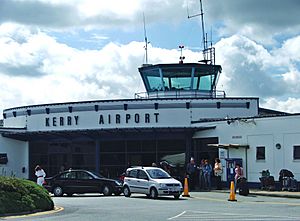
The main roads into Kerry are the N21 from Limerick and the N22 road from Cork. Both of these roads end in Tralee. Kerry Airport is located between Castleisland and Farranfore, connecting the N21 and N22 roads.
Inside Kerry, important roads include the famous Ring of Kerry. This route follows the N70 road, which goes around the Iveragh Peninsula and connects with the N71 road to west Cork at Kenmare. The N86 connects Tralee with Dingle, and the N69 from Limerick links Listowel and Tralee through north Kerry.
Kerry is also developing a network of greenways. These are paths for walking and cycling. The North Kerry Greenway, South Kerry Greenway, and Tralee-Fenit Greenway are either being built or planned.
Train Services
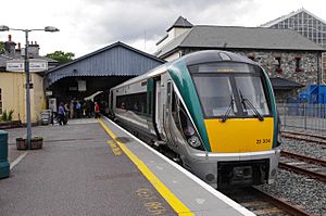
Kerry has train services at Tralee railway station, Farranfore railway station, Killarney railway station, and Rathmore railway station. These stations connect to Cork and Dublin Heuston, usually by changing trains at Mallow.
In the past, there were more train lines that went to the peninsulas and the north of the county. However, these were closed in the 1950s and 1960s. For example, the Tralee and Dingle Light Railway, a narrow-gauge railway, closed in 1953.
A unique Lartigue Monorail operated between Listowel and Ballybunion from 1882 to 1924. A small section of it was rebuilt in 2003.
Bus Services
Bus Éireann runs many bus services throughout Kerry. The main hubs for these services are Killarney and Tralee. There are also local link services that run throughout the county.
Air Travel
Kerry Airport is located at Farranfore, in the middle of the county. It has had regular flights since 1989. You can fly to places like London, Frankfurt-Hahn, Faro, and Alicante with Ryanair. Aer Lingus Regional also has year-round flights to Dublin. The airport is close to Farranfore railway station.
Sea Ports
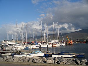
Fenit harbour, near Tralee, is a regional port that can handle large ships. Big container cranes made by Liebherrs in Killarney are often shipped from here. The harbor at Dingle is one of Ireland's important fishing ports. In the north of the county, a ferry service runs from Tarbert to Killimer in County Clare.
Hospitals in Kerry
Kerry has several hospitals. The main public hospital is University Hospital Kerry. It's the second-largest hospital in the Health Service Executive South Region and serves County Kerry, as well as parts of north Cork and west Limerick. There's also a private hospital, Bon Secours Hospital, in Tralee. Smaller community hospitals are located in Cahirciveen, Dingle, Kenmare, Killarney, and Listowel.
Education in Kerry
The Munster Technological University (MTU) is the main higher education institution in Kerry. It used to be called the Institute of Technology, Tralee. It was founded in 1977 and became a university in 2019 when it merged with Cork Institute of Technology. About 3,500 students attend MTU. It has two campuses in Tralee.
Famous Families and Titles from Kerry
Many Irish surnames come from families who lived in the Kerry area. Some examples include Falvey, Foley, McCarthy, Murphy, O'Connor, O'Sullivan, and O'Connell.
The area was also home to important Norman-Irish families, like the FitzMaurices and the Desmonds (a branch of the FitzGeralds).
Some noble titles in the British Peerage of Ireland are linked to families who had lands in Kerry:
- the Knight of Kerry – a branch of the Fitzgeralds who owned land on Valentia Island.
- the Earl of Kenmare – the descendants of Sir Valentine Browne who were given lands in Killarney.
- the Earl of Desmond – the Fitzgeralds of Desmond, who had lands in North Kerry until they were taken after the Desmond Rebellions.
- the Marquess of Lansdowne – the descendants of Sir William Petty who received lands in Kenmare.
- the Earl of Kerry – the Fitzmaurice family.
- the Earl of Listowel – the Hare family.
- the Baron Ventry – the Mullins family who had lands on the Dingle Peninsula.
Notable People from County Kerry
|
Images for kids
See also
 In Spanish: Condado de Kerry para niños
 | Audre Lorde |
 | John Berry Meachum |
 | Ferdinand Lee Barnett |


