
Tearaght Island facts for kids
|
Native name:
an Tiaracht
|
|
|---|---|

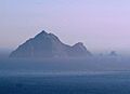
An Tiaracht seen from Inis Tuaisceart
|
|

Tearaght Island
Location in island of Ireland
|
|
| Geography | |
| Location | Atlantic Ocean |
| Coordinates | 52°4′32.4″N 10°39′4.6″W / 52.075667°N 10.651278°W |
| Archipelago | Blasket Islands |
| Highest elevation | 200 m (700 ft) |
| Administration | |
|
Ireland
|
|
| Province | Munster |
| County | County Kerry |
| Demographics | |
| Population | 0 (0) |
| Pop. density | 0 /km2 (0 /sq mi) |
| an Tiaracht | |
|---|---|
| Highest point | |
| Elevation | 200 m (660 ft) |
| Prominence | 200 m (660 ft) |
| Listing | Marilyn |
| Geography | |
| OSI/OSNI grid | V178949 |
Tearaght Island or Inishtearaght (Irish: An Tiaracht, meaning 'the westerly') is a rocky island located west of the Dingle Peninsula in Ireland. It is not currently inhabited by people.
Contents
Where is Tearaght Island Located?
Tearaght Island is the westernmost island in the Blasket Islands group. This also makes it the westernmost island of Ireland. It is one of the most westerly points in Europe, along with places like Iceland and the Azores.
How Big is Tearaght Island?
The island stretches about one kilometre from east to west. It is about 500 metres from north to south. Tearaght Island has two main parts. The eastern part is higher, reaching 200 metres (656 feet) tall. The western part is a bit lower, rising to 116 metres (381 feet). A narrow strip of rock connects these two parts. This strip even has a natural tunnel running through it!
What Animals Live on Tearaght Island?
Tearaght Island is a very important home for many seabirds. Just like the other Blasket Islands, it has large numbers of birds.
Important Bird Populations
The island is especially important for two types of birds:
These bird populations are considered important around the world. Another type of bird, Leach's storm-petrels, has also been seen on the island. However, experts are not yet sure if they are breeding there. The number of auks, like puffins, has changed a lot over the years.
The Inishtearaght Lighthouse
A lighthouse was built on Tearaght Island in 1870. Its job is to help ships navigate safely. The lighthouse was updated in 1988 to work automatically. This means people no longer need to live on the island to operate it.
Lighthouse Details
The lighthouse is looked after by the Commissioners of Irish Lights. Here are some facts about it:
- The lighthouse tower is 17 metres (56 feet) tall.
- The light itself is 84 metres (276 feet) above the sea.
- Its light can be seen from up to 19 nautical miles (35 kilometres or 22 miles) away.
The island also has a very steep funicular rail track. This track is the steepest of its kind in Europe. It was used to move supplies up and down the steep slopes to the lighthouse.
Images for kids
-
An Tiaracht seen from Inis Tuaisceart
