
Inishtooskert facts for kids
|
Native name:
Inis Tuaisceart
|
|
|---|---|
_-_geograph.org.uk_-_220149.jpg)
Inishtooskert, seen from the mainland
|
|

Inishtooskert
Location in island of Ireland
|
|
| Geography | |
| Location | Atlantic Ocean |
| Coordinates | 52°07′50″N 10°34′42″W / 52.13045°N 10.57831°W |
| Archipelago | Blasket Islands |
| Highest point | 172 |
| Administration | |
| Province | Munster |
| County | Kerry |
| Demographics | |
| Population | 0 |
| Inishtooskert | |
|---|---|
| Highest point | |
| Elevation | 172 m (564 ft) |
| Prominence | 172 m (564 ft) |
| Listing | Marilyn |
| Geography | |
| Location | County Kerry, Ireland |
| OSI/OSNI grid | Q235007 |
Inishtooskert is a fascinating island located off the coast of County Kerry, Ireland. It's the most northern island in the beautiful Blasket Islands group. This island is special because of its unique shape, which looks like a sleeping giant or a dead man when you see it from the east! It's a wild and natural place, completely uninhabited by people, but it's home to lots of amazing seabirds.
Contents
What's in a Name?
The name Inishtooskert comes from the Irish language words Inis Tuaisceart, which simply means "northern island." So, its name tells you exactly where it is among the Blasket Islands!
But that's not the only name for this island. People also call it An Fear Marbh, which means "the dead man" in Irish, or "the sleeping giant." This nickname comes from how the island looks when you view it from the east, as if a giant is lying down asleep.
Nature and Wildlife
Inishtooskert is a very important place for nature, especially for birds. It's home to large groups of seabirds that come here to nest and raise their young.
Home to Storm-Petrels
One of the most special birds found here is the European storm-petrel. In 2000, a survey counted over 27,000 pairs of these tiny birds on Inishtooskert. This makes it the biggest colony of European storm-petrels in all of Ireland! These birds are small and mostly active at night, flying over the ocean to find food.
Ancient Stone Buildings
Besides its amazing wildlife, Inishtooskert also has old stone buildings. These ruins show that people once lived or visited this remote island a very long time ago. They are a cool reminder of the island's history.
Photo Gallery
-
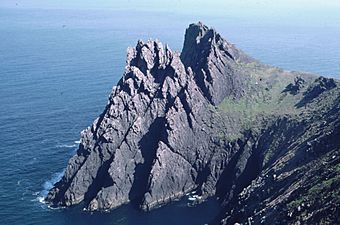
The northern cliffs of Inishtooskert
-
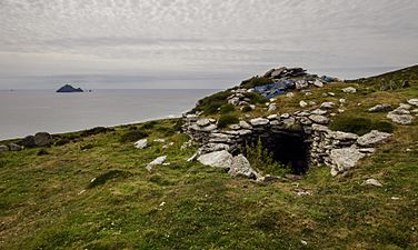
Early Medieval ecclesiastical site on the island


Images for kids
-
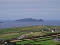
Inishtooskert seen from the mainland
