
Mount Brandon facts for kids
Quick facts for kids Mount Brandon(and the Brandon Group) |
|
|---|---|
| Cnoc Bréanainn | |

Mount Brandon photographed from Brandon Peak, with its distinctive east–west contrast.
|
|
| Highest point | |
| Elevation | 951.7 m (3,122 ft) |
| Prominence | 934 m (3,064 ft) |
| Listing | P600, Marilyn, Furth, Hewitt, Arderin, Simm, Vandeleur-Lynam |
| Naming | |
| English translation | Brendan's hill |
| Language of name | Irish |
| Geography | |

Mount Brandon
(and the Brandon Group) Location in island of Ireland
|
|
| Parent range | Brandon Group |
| OSI/OSNI grid | Q4604211605 |
| Topo map | OSI Discovery 70 |
| Geology | |
| Age of rock | Devonian |
| Mountain type | Purple sandstone & siltstone |
| Climbing | |
| Easiest route | Saint's Route (Cosán na Naomh) |
Mount Brandon (also called Brandon or Cnoc Bréanainn in Irish) is a very tall mountain in Ireland. It stands at 952 meters (3,122 feet) high. This makes it one of the ten highest mountains in the country. It is the 8th or 9th highest, depending on how mountains are measured.
Mount Brandon is the tallest mountain in Ireland outside of the MacGillycuddy's Reeks range. It also sticks out more than almost any other Irish peak, except for Carrauntoohil, which is Ireland's highest mountain.
Mount Brandon is part of a long, high group of mountains called the Brandon Group. This group is found on the Dingle Peninsula in County Kerry. The mountain and its range are named after Saint Brendan, a famous Irish saint. It is also the end point of an old Christian walking trail called Cosán na Naomh, which means "The Saint's Road". Many people enjoy hiking on Mount Brandon, using routes like the Faha Route or walking the whole mountain range.
Contents
What is Mount Brandon Made Of?
Mount Brandon is mostly made of a type of rock called Old Red Sandstone. This sandstone has a purple-red color. It formed from tiny bits of sand and rock. This rock usually does not have many fossils. Its color even gave the name to a nearby mountain, Purple Mountain.
Geologists (scientists who study rocks) say these are some of the oldest rocks from the Devonian period in Ireland. The rock has different parts, like quartz stones, mudstones, and siltstones.
How Mount Brandon Looks
Mount Brandon is in the middle of a long, high ridge called the Brandon Group. This ridge stretches for about 10 kilometers (6 miles) across the Dingle Peninsula. Besides Mount Brandon, the group has seven other major peaks. These include Brandon Peak (840 meters), Benagh (822 meters), and Faha Ridge (809 meters).
One special thing about the Brandon Group is how different its two sides are. The western side has gentle, grassy slopes. But the eastern side has steep cliffs and deep, bowl-shaped valleys called corries. The long ridge perfectly separates these two very different landscapes.

Mount Brandon's rugged shape was created by glaciers during the ice age. These glaciers carved out the deep corries on the mountain's eastern side. The very top of Mount Brandon is rounded and smooth. This suggests it might have been a nunatuk, which is a mountain peak that stuck out above the ice sheet. This is different from Brandon Peak, which looks more like mountains in the Alps.
On the eastern side of Brandon, in its deep corries, there are several rocky areas with small lakes. These lakes are like a chain, getting bigger as they go down the mountain. They are called paternoster lakes. Some of these lakes include Locha Chom an Chnoic and Loch na Lice. This area is very beautiful and is often photographed by hikers.
Mount Brandon is considered a very important mountain for hikers. It is one of 34 mountains in Britain and Ireland called "Furths." These are mountains over 3,000 feet (914 meters) tall that meet certain rules, but are outside of Scotland.
Why is it Called Brandon?

The mountain is named after Saint Brendan the Navigator. He was born in County Kerry around 484 AD. Saint Brendan is famous for a legendary journey he took in a boat made of wood and leather. He was searching for a place called the "Isle of the Blessed."
The story of Saint Brendan says that he spent three days fasting on the mountain before his voyage. An angel visited him there, and he saw a vision of "a great land to the west." The story describes the mountain as being surrounded by the ocean. This matches how Mount Brandon looks, being so close to the sea.
Some people think the mountain was a special place for pilgrimages even before Saint Brendan and Christianity came to Ireland. It might have been important because it is so far west and so high. This means it is one of the last places in Ireland where you can see the sun set.
Hiking on Mount Brandon

There are several ways to hike to the top of Mount Brandon.
The Saint's Route
The easiest way to reach the summit is from the west. This path is part of an old pilgrim trail called The Saint's Route (Cosán na Naomh). This route starts about 18 kilometers (11 miles) away in Ventry. The hiking part begins from a car park in Ballybrack. You follow a clear grassy path marked by large crosses all the way to the top of Mount Brandon. Then, you walk back the same way. This 8-kilometer (5-mile) hike usually takes 3 to 4 hours.
The Faha Route

Another beautiful way to hike is the Faha Route, also known as the Pilgrim's Path. This 9-kilometer (5.6-mile) hike takes 4 to 5 hours. It starts from the east, near the Faha Grotto outside Cloghane. This route gives you amazing views of the deep corries and lakes on Brandon's eastern side. You follow a trail below the Faha Ridge to the summit and then return to the grotto.

The Full Ridge Walk
For experienced hikers, there is a longer walk that covers the entire Mount Brandon range. This is called the "full ridge walk" and is considered one of the best ridge walks in Ireland. It crosses the whole 15-kilometer (9-mile) ridge of the Brandon Group. This hike takes about 6 to 7 hours to complete.
Peaks of the Brandon Group
The Brandon Group has many peaks. Here are some of the main ones:
| Name | Irish Name | Height (m) | Height (ft) |
|---|---|---|---|
| Brandon | Cnoc Bréanainn | 952 | 3,122 |
| Brandon North Top | — | 895 | 2,938 |
| Brandon Far North Top | — | 840 | 2,756 |
| Brandon Peak | Barr an Ghéaráin | 840 | 2,756 |
| Benagh | Binn Faiche | 822 | 2,697 |
| Faha Ridge | Na Poirt | 809 | 2,654 |
| Gearhane | An Géarán | 803 | 2,635 |
| Masatiompan | Más an Tiompáin | 762 | 2,500 |
| Piaras Mór | — | 746 | 2,447 |
The Pilgrim's Journey
_-_geograph.org.uk_-_219293.jpg)
Because of its connection to Saint Brendan, Mount Brandon is a popular place for Irish Catholic pilgrims. The mountain's height and its location at the very west of Ireland were very important to Saint Brendan.
The pilgrimage route, Cosán na Naomh ("The Saints Road"), starts on Ventry Strand. It ends at a small stone building on Brandon's summit called Séipéilín Bréanainn ("Brendan's Oratory"). People believe Saint Brendan used this building. The path to the top is marked by small white crosses, and a large metal cross stands on the peak. Some think this pilgrimage started even before Christianity came to Ireland.
In 1997, the Irish Heritage Council started a project to fix up old Irish pilgrimage paths. Cosán na Naomh was one of the paths chosen. An 18-kilometer (11-mile) marked trail was built from Ventry Strand to the grotto at the bottom of Mount Brandon. For safety, the trail is not marked all the way to the very top of Brandon. The starting point at Ventry is where pilgrims would have arrived by boat. The trail also passes important old church sites like Gallarus Oratory.
Images for kids
-
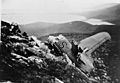
Wreckage of Sunderland Aircraft, Faha Ridge 1943.

See also
 In Spanish: Monte Brandon para niños
