
Caherconree facts for kids
Quick facts for kids Caherconree |
|
|---|---|
| Cathair Conraoi | |

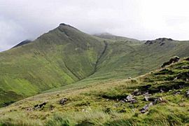
Summit of Caherconree (in cloud), and pyramidal summit of the promontory fort (near), from south
|
|
| Highest point | |
| Elevation | 835 m (2,740 ft) |
| Prominence | 129 m (423 ft) |
| Listing | 100 Highest Irish Mountains, Hewitt, Arderin, Simm, Vandeleur-Lynam |
| Naming | |
| English translation | stone fort of Cú Roí |
| Language of name | Irish |
| Geography | |

Caherconree
Location in island of Ireland
|
|
| Location | Dingle Peninsula, County Kerry, Ireland |
| Parent range | Slieve Mish Mountains |
| OSI/OSNI grid | Q7331707260 |
| Topo map | OSi Discovery 71 |
| Geology | |
| Mountain type | Aeolian sandstone |
| Climbing | |
| Easiest route | Caherconree Fort Trail |
| Official name | Caherconree Promontory Fort |
| Reference no. | 184 |
Caherconree is a tall mountain in County Kerry, Ireland. It stands at 835 metres (2,740 ft) high. This makes it one of the highest mountains in Ireland. It's also the second-highest mountain in the Slieve Mish Mountains, which are part of the beautiful Dingle Peninsula. Caherconree is special because it has an ancient stone fort on one of its slopes. This fort is very old and is now a protected National Monument. The name Caherconree means 'Cú Roí’s stone fort' in Irish.
Contents
What's in a Name?
The name Caherconree comes from an old Irish legend. It is named after Cú Roí mac Daire. He was a legendary king from the area called Munster. Cú Roí appears in many old Irish stories. These tales often involve other famous characters like Cú Chulainn.
Where is Caherconree?
Caherconree is the second-highest mountain in the Slieve Mish Mountains. These mountains are found at the eastern end of the Dingle Peninsula in County Kerry. Caherconree is part of a group of big mountains. They form a "horseshoe" shape around a deep valley called Derrymore Glen.
Nearby Peaks
Other mountains in this group include Gerahane, which is 792 metres (2,598 ft) tall. Its Irish name, An Géarán, means "the fang." The highest mountain in the Slieve Mish range is Baurtregaum, standing at 851 metres (2,792 ft).
Climbing Caherconree
Many people enjoy climbing Caherconree. There are different paths you can take.
Easy Trail to the Fort
The easiest way to reach Caherconree is a 4-kilometer walk. It takes about two hours to go there and back. You start from a road called Bóthar na gCloch, which means "road of the stones." From a car park there, you follow the Caherconree Fort Trail. This path leads you right to the ancient stone fort. From the fort, it's easy to reach the top of Caherconree.
The Derrymore Glen Horseshoe
For a longer adventure, you can try the Derrymore Glen Horseshoe. This is an 11-kilometer loop that takes about five hours. It starts at the bottom of the Derrymore Glen valley. You first climb to the top of Gearhane. Then you walk around the "horseshoe" shape to Caherconree. Finally, you reach the summit of Baurtregaum. This route offers amazing views of the valley. It also lets you see most of the main peaks in the Slieve Mish range. Some guidebooks call it The Slieve Mish Circuit.
The Ancient Caherconree Fort
Caherconree is famous for its promontory fort. This fort is called Caherconree Promontory Fort. It sits about two-thirds of the way up the mountain's southwestern side. The fort is 683 metres (2,241 ft) high. It looks over the Bóthar na gCloch road.
A Fort from the Iron Age
This fort was built during the Iron Age. That was a long, long time ago! The fort is naturally protected on three sides by steep cliffs.
Legends of the Fort
In Irish mythology, this fort was home to Cú Roí mac Dáire. Stories say he could make the fort spin around at night. This made it impossible for attackers to find the entrance.
One famous story is about a king's daughter named Bláthnat. Cú Roí took her to the fort against her will. Her lover, Cú Chulainn, planned to rescue her. Bláthnat helped him by signaling when to attack. She poured milk into a nearby stream. This stream is now called the Finglas. Its name means "the white stream" in Irish. Bláthnat also tricked Cú Roí into making his fort bigger. She said it was too small for such a great leader. This made him take down the walls, creating a chance for Cú Chulainn to attack.
Fin MacCool's Chair
Between the tops of Caherconree and Gearhane, there's a cool rock formation. It's called Fin MacCool's Chair. It's named after the legendary giant Fionn mac Cumhaill.
Gallery
-
Peak of the hill fort
-
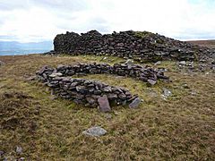
Hill fort ruins
-
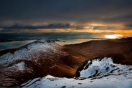
View south from summit
-
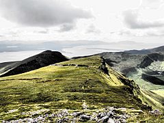
Hill fort from summit


