
Baurtregaum facts for kids
Quick facts for kids Baurtregaum |
|
|---|---|
| Barr Trí gCom | |

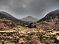
Baurtregaum and the lakes in Derrymore Glen
|
|
| Highest point | |
| Elevation | 851 m (2,792 ft) |
| Prominence | 643 m (2,110 ft) |
| Listing | P600, 100 Highest Irish Mountains, Marilyn, Hewitt, Arderin, Simm, Vandeleur-Lynam |
| Naming | |
| English translation | top of the three hollows |
| Language of name | Irish |
| Geography | |

Baurtregaum
Location in island of Ireland
|
|
| Location | Dingle Peninsula, County Kerry, Republic of Ireland |
| Parent range | Slieve Mish Mountains |
| OSI/OSNI grid | Q7498607665 |
| Topo map | OSi Discovery 71 |
| Geology | |
| Mountain type | Quartz-pebble conglomerate |
| Climbing | |
| Easiest route | Via the Derrymore Glen |
Baurtregaum is a tall mountain in Ireland. It stands at 851 metres (2,792 ft) high. This makes it one of the highest peaks in the country.
The mountain's name, Barr Trí gCom, comes from the Irish language. It means "top of the three hollows." Baurtregaum is located in County Kerry, on the Dingle Peninsula. It's the tallest mountain in the Slieve Mish Mountains range.
Contents
What's in a Name?
The name Baurtregaum means "top of the three hollows." These "hollows" are actually valleys. They are called Derrymore, Derryquay, and Curraheen. These valleys cut into the sides of the mountain.
Exploring Baurtregaum's Geography
Baurtregaum is the highest mountain in the Slieve Mish Mountains. This mountain range is found at the eastern end of the Dingle Peninsula. It's connected to another high peak, Caherconree, by a ridge. Caherconree is 835 metres (2,740 ft) tall.
Other Peaks Nearby
Baurtregaum has several smaller peaks around it. These are like its helper mountains:
- Baurtregaum NW Top is 723 metres (2,372 ft) high.
- Baurtregaum NE Top is 819 metres (2,687 ft) high. It has a northern part called Scragg.
- Baurtregaum Far NE Top is 603 metres (1,978 ft) high.
The Beautiful Glens
The most famous "hollow" is the Derrymore Glen. A river called the Derrymore River flows through it. This glen has three beautiful lakes. They are surrounded by the steep sides of Baurtregaum and Caherconree. Another important valley is the Curraheen Glen. The Curraheen River runs through this eastern glen.
Hiking Adventures
A very popular way to explore Baurtregaum is by doing the Derrymore Glen Horseshoe hike. This hike is about 11 kilometers long. It usually takes around 5 hours to complete.
The Horseshoe Route
The hike starts at the bottom of the Derrymore Glen. Hikers first climb to the peak of Gearhane, which is 792 metres (2,598 ft) high. Then, the path goes around in a "horseshoe" shape. It leads to Caherconree and finally to the top of Baurtregaum.
Choosing Your Way Down
When it's time to come down, hikers can choose different paths. You can go down the Baurtregaum NW Top path. Or you can take the Baurtregaum NE Top path, which includes the Scragg. Both paths lead back to the start of the Glen. This route is loved for its amazing views of the Glen. It also lets you see most of the main peaks in the Slieve Mish range. Some guidebooks even call it The Slieve Mish Circuit.
Images for kids
-
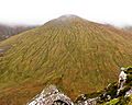
Baurtregaum NW Top
-
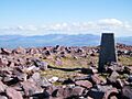
Baurtregaum summit
-
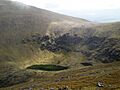
Lakes of Derrymore Glen
-
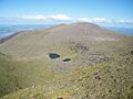
Baurtregaum from Caherconree
-
Baurtregaum NW Top


