
Skellig Michael facts for kids
|
Native name:
Sceilg Mhichíl
|
|
|---|---|
.jpg)
Skellig Michael
|
|
| Lua error in Module:Location_map at line 420: attempt to index field 'wikibase' (a nil value). | |
| Geography | |
| Location | Atlantic Ocean |
| Area | 21.9 ha (54 acres) |
| Highest elevation | 218 m (715 ft) |
| Administration | |
|
Republic of Ireland
|
|
| County | Kerry |
| Demographics | |
| Population | 0 |
| UNESCO World Heritage Site | |
| Official name | Sceilg Mhichíl |
| Criteria | Cultural: iii, iv |
| Inscription | 1996 (20th Session) |
Skellig Michael (Irish: Sceilg Mhichíl), also known as Great Skellig, is a tall, rocky island. It is located about 11.6 kilometers west of the Iveragh Peninsula in County Kerry, Ireland. The island gets its name from the archangel Michael. The word "Skellig" comes from the Irish language word sceilig, which means "a splinter of stone".
Skellig Michael has a smaller twin island nearby called Little Skellig (Sceilig Bheag). Little Skellig is smaller and people are not allowed to land there. Both islands formed about 374 to 360 million years ago. This happened during a time when mountains were forming, like the MacGillycuddy's Reeks mountain range. Later, rising sea levels separated them from the mainland.
Skellig Michael is about 21.9 hectares (54 acres) of rock. Its highest point, called the Spit, is 218 meters (714 feet) above sea level. The island has two main peaks with a valley in between, known as Christ's Saddle. This makes the island very steep and rugged.
The island is famous for its ancient Gaelic monastery. This monastery was built between the 6th and 8th centuries. It is also home to many different animals. These include gannets, puffins, razorbills, and about fifty grey seals. The island is very important to archaeologists. This is because the old Christian monastery is still in amazing condition.
The island also has the remains of an old tower, a large stone row, and a cross-shaped stone called the Wailing Woman. The monastery sits high up, about 168 to 183 meters (550 to 600 feet) above the sea. Christ's Saddle is at 129 meters (422 feet), and the flagstaff area is at 37 meters (120 feet) above sea level.
You can reach the monastery by climbing narrow, steep stone steps. These steps start from three different landing spots. The hermitage on the south peak is very hard and dangerous to reach. It is mostly closed to the public. Because it's often hard to get to the island from the mainland, Skellig Michael is only open during the summer months. In 1996, Skellig Michael was named a UNESCO World Heritage Site.
Contents
What's in a Name?

The word "Skellig" comes from the old Irish word sceillec. This means "small or steep area of rock". This word is not common in Irish place names. It appears in only a few other places, like Bunskellig in County Cork. It is also seen at the Temple-na-Skellig church in Glendalough, County Wicklow.
Some people think the word might come from the Old Norse word skellingar. This word means "the resounding ones". An older, less used Irish name for the island is Glascarraig. This means "the green rock".
The first known mention of the Skelligs is in old Irish stories called the Irish annals. These stories tell of a shipwreck around 1400 BC. It was said to be caused by the Tuatha Dé Danann, a magical race from Irish mythology. Legend says that Irr, son of Míl Espáine, drowned and was buried on the island.
Another story says that Duagh, King of West Munster, ran to "Scellecc" in the 5th century. This was after a fight with the Kings of Cashel. However, we don't know if this story is completely true. Other old writings also mention the island. These include the Lebor Gabála Érenn and Cath Finntrágha.
Island Features

Skellig Michael is a very steep, rocky island. It covers about 18 hectares (45 acres) on the Atlantic coast. It is off the Iveragh peninsula in County Kerry. The island is about 11.7 kilometers (7.25 miles) west-northwest of Bolus Head.
Its twin island, Little Skellig, is closer to the land. It is much harder to visit because of its very steep cliffs. The small Lemon Rock island is about 3.6 kilometers (2.25 miles) further inland. Nearby Puffin Island is another home for seabirds. The Skelligs, along with some of the Blasket Islands, are the most western part of both Ireland and Europe.
The island has two main peaks. The north-east peak is where the monastery is built. It is 185 meters (607 feet) above sea level. The south-west peak has the hermitage. It is 218 meters (715 feet) above sea level. These two high points are on either side of a dip called Christ's Saddle.
How the Island Formed
The islands are made of Old Red Sandstone and squashed slate. They formed between 360 and 374 million years ago. This happened when the MacGillycuddy's Reeks and Caha Mountains mountain ranges were rising. This was during the Devonian period. At that time, Ireland was part of a larger landmass and was south of the equator.
The island's peaks and valleys have steep ridges. These formed about 300 million years ago when the land folded and mountains were created. When the Atlantic Ocean rose, it made deep sea inlets. This left the Skelligs separated from the mainland. The rock is very hard and has many cracks.
A large part of the rock broke away along a major crack. This created Christ's Saddle, the dip between the peaks. The island's rock is also deeply worn away by wind and water.
.jpg)
The Wailing Woman rock is in the middle of the island. It is on the way up before Christ's Saddle. It is about 122 meters (400 feet) above sea level. This area has about 1.2 hectares (3 acres) of grassland. It is the only flat and fertile part of the island. Because of this, we can find signs of medieval farming there.
The path from Christ's Saddle to the top is called the Way of the Christ. This name shows how dangerous the climb is for people. Along this path, you can see the Needle's Eye peak. This is a stone chimney 150 meters (492 feet) above sea level. There are also 14 stone crosses with names like the "Rock of the Women's piercing caoine". These names also show how hard the climb is. Further up is the Stone of Pain area. This includes a spot called the Spit. It is a long, narrow piece of rock with steps only 60 centimeters (2 feet) wide.
Island Bays
The island has three main bays. These are Blind Man's Cove to the east, Cross Cove to the south, and Blue Cove to the north. All three can be used to get to the island from the sea. Each bay has steps carved into the rock.
The main landing cove is on the eastern side. It is called Blind Man's Cove. This cove is open to strong sea swells and high waves. This makes it hard to approach outside of summer. The bay's pier is under a very steep cliff. Many birds live on this cliff. The pier was built in 1826. It leads to a small stairway that goes to the old lighthouse. The steps then split into two staircases. The oldest path, which is mostly not used now, goes straight to the monastery.
Blue Cove is the hardest place to land. It can only be reached about 20 days a year. Writer Des Lavelle noted how hard it is to reach the island. He said, "the fact that the monks of old undertook the giant task of constructing a stairway to this bleak cove is a good argument that the weather conditions then were far better than now."
Wildlife on Skellig Michael

Skellig Michael has steep sea cliffs and three bays. Most of its inland area has thin soil on steep ground. There are patches of plants, but they are exposed to sea spray. Even so, the island has much more diverse wildlife than the mainland. As an island, it offers a safe home to many different plants and animals. Many of these are unusual for Ireland.
It has a large number of seabirds. These birds are now protected because the island is a state-owned nature reserve. The Skellig Islands were made a Special Protection Area in 1986. This was because they have an unusually large variety and number of birds.

The island is home to eyries for peregrine falcons. Other interesting birds include fulmars, Manx shearwaters, storm petrels, gannets, kittiwakes, guillemots, and Atlantic puffins. A group of goats used to live on the island. The island also has rabbits and house mice. These animals were brought to the island more recently, probably in the 1800s by lighthouse keepers. Grey seals also rest on the island's ledges.
History of the Island
The Monastery
Skellig Michael was mostly empty until the Augustinian monastery was built. Many islands off the west coast of Ireland have early Christian monasteries. Monks liked these places because they were isolated. They also had plenty of rock for building. There are many monasteries off the coast of County Kerry. Nine of them are on islands off the Iveragh and Dingle peninsulas.
Old records, called the Annals of Inisfallen, mention a Viking attack in 823. The site was named after Saint Michael by at least 1044. This is when the death of "Aedh of Scelic-Mhichí" was recorded. However, it might have been named after Saint Michael as early as 950. Around that time, a new church was added to the monastery. It was called Saint Michael's Church. By the early 1500s, the island was a regular place for pilgrims to visit.
Stairs and Paths


Each of the three landing areas leads to long flights of steps. These are known as the east, south, and north steps. The first monks who lived on the island built them. They might have been part of a larger network of paths. Signs of other, possibly older, steps have been found elsewhere on the island.
Archaeological findings show that the bottom parts of each set of steps were cut into the rock. Higher up, they used more stable dry stone masonry. This was done once they reached a height where sea waves would not damage them. Later, the bottom steps were replaced with dry-stone paths.
The north steps start from Blue Cove. They have two long, steep, continuous flights. These are called the upper and lower steps. The upper path was built from dry stone. In some places, it is in very poor condition. Because they are built on a steep cliff, they can be damaged by erosion and falling stones. The lower rock-cut part has been heavily worn by the sea. Some of the ground around them has collapsed. Where steps are missing, they have been replaced with ramps. A low wall was added at their lowest part in the 1820s. They were made wider when the lighthouse was built.
The south steps are used most often today. They join the north steps at Christ's Saddle. From there, they lead to the monastery. They pass by several old features, including a prayer station and walls. They are in good condition. The lighthouse builders probably repaired them. Their weakest point, right above Christ's Saddle, gets worn out from many visitors. It needs constant care. The landing steps might have been built by the lighthouse builders. There are 14 steps separate from the main landing that are almost impossible to reach. They don't lead to the sea or to the higher levels.
The bottom of the east steps above Blind Man's Cove was heavily blasted with dynamite in 1820. This happened during the building of the pier and Lighthouse Road. They are now impossible to reach from the landing point. The steps above this level are on a very steep climb along a sheer cliff. They have been preserved. Most recently, in 2002/2003, a lot of overgrown plants were removed. They are in good condition today.
The Monastery Buildings
The monastery is built on a flat, terraced area. It is about 183 meters (600 feet) above sea level. It has two small churches (oratories), a cemetery, crosses, stone slabs with crosses, and six domed clochán-type beehive cells. One of these cells has fallen down. It also has a medieval church. The cells and oratories are all built with dry stone. The church, built later, uses stone with mortar.

We don't know exactly when the monastery was founded. Like many early Christian sites in Kerry, some people say Saint Finnia founded it. But historians doubt this. The first clear mention of monks on the island is a record from the 8th century. It talks about the death of "Suibhini of Skelig". However, Fionán is said to have founded the monastery in the 6th century.
The Annals of the Four Masters tell about events at the Skelligs between the 9th and 11th centuries. These records suggest that Eitgall of Skellig, the monastery's abbot, was taken by Vikings in 823. He later died of starvation. The Vikings attacked again in 838. They raided churches in Kenmare town, Skellig, and Innisfallen Island. The Augustinian abbey in Ballinskelligs was founded in 950. This was the same year that Blathmhac of Sceilig died. Finally, the annals mention the death of Aedh of Sceilig Michael in 1040.

The largest hut, called cell A, is 14.5 meters (47.5 feet) long and 3.8 meters (12.5 feet) wide. It is 5 meters (16.4 feet) high. Like the other huts, its inside walls are straight. Then they narrow to form its dome roof. Stones sticking out on the inside, like pegs, are about 2.5 meters (8.2 feet) high. They supported the roof. Some might have held up upstairs living areas. Stones sticking out on the outside probably held down thatch roofing. Some cells have small spaces that might have been cupboards.
The main oratory is shaped like a boat. It is 3.6 meters (11.8 feet) long and 4.3 meters (14.1 feet) wide. It has an altar and a small window on its eastern wall. The small oratory is on its own terrace. It is a bit far from the main complex. It is 2.4 meters (7.9 feet) long, 1.8 meters (5.9 feet) wide, and 2.4 meters (7.9 feet) high. It has a low door (0.9 meters by 0.5 meters) and a rather large, one-meter-high window on its north-eastern wall.
St. Michael's Church dates back to the 10th or early 11th century. It was originally built mostly from lime mortar. It used sandstone brought from Valentia Island. Today, most of it has fallen down. Only its eastern window is still standing. In the center of the church is a modern gravestone from 1871. It was put there for the family of one of the lighthouse keepers.
The Monk's Graveyard has partly collapsed. It is smaller than it used to be. It has stone crosses with simple patterns on its west side. Two of these are very detailed. They are thought to be early features of the site. In total, over a hundred individual stone crosses have been found on the island. There are several large upright stones on its north and west sides. There are two dry stone leachta (stone altars or monuments) on the site. The larger one is between Saint Michael's Church and the main Oratory. It is thought to be older than both. It once had a large upright cross at its western end, which is now broken. The other is against the monastery wall to the south of the oratory. Human remains have been found under both.
-
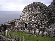
Graveyard and large oratory


It is believed that no more than twelve monks and an abbot lived at the monastery at any one time. The monastery was continuously used until the late 12th or early 13th century. It remained a place for pilgrimages even into modern times. The monks on the island ate differently from those on the mainland. They had less farmable land for growing grain. So, vegetable gardens were very important. They mostly ate fish, and the meat and eggs of birds nesting on the islands.
The monastery was abandoned for several reasons. The climate around Skellig Michael might have become colder and stormier. There were also Viking raids. Changes to the Irish Church structure also played a part. It was probably a mix of these things that made the monks leave the island. They moved to the abbey in Ballinskelligs. A historian named Giraldus Cambrensis wrote about this move in the late 12th century. He said the monks had moved to a new place on the mainland.
The Hermitage
The hermitage is on the opposite side of the island from the monastery. It is below the south peak. It is much harder and more dangerous to reach. Today, you can only visit the south peak if you arrange it beforehand. You reach it from Christ's Saddle by climbing very narrow and steep steps cut into the rock. These steps are open on all sides to strong winds, sometimes almost hurricane-force. The path goes through the Needle's Eye. This is a rock chimney formed by a narrow vertical crack in the peak.
We don't know as much about the hermitage's origin and history as we do about the monastery. But it is thought to have been built in the 9th century. It has several enclosed areas and flat platforms. These are on three main terraces cut into the rock. The terraces are called the Oratory, Garden, and Outer Terraces.
The oratory terrace is 200 meters (656 feet) above sea level. It is 15 meters (49 feet) below the summit. It is the largest terrace and is in good condition. The main oratory is still mostly whole. It has its original altar, a bench, a water tank, and what looks like the remains of a shrine. The stone work is typical of the Early Christian period in Ireland.
It seems likely that the hermitage was built after the monastery. It would have been very hard to build. Large stones would have had to be moved up almost vertical cliffs. The builders would have needed the monastery as a base. The freezing and thawing of water along the island's main crack provided the builders with many materials.
The inside of the main building is 2.3 meters (7.5 feet) long and 1.2 meters (3.9 feet) wide. The surrounding wall is made mostly of small stones. Although it is now worn down, it would have been 1 to 1.5 meters (3.3 to 4.9 feet) high. The inside is now full of fallen stone rubble. It also has pieces of a 2.1-meter (7-foot) tall stone cross. The stone altar outside it was probably used as a shrine or altar. It is too small to have been a burial site.
The outer terrace is on three stepped ledges. It is some distance from the main complex and hard to reach. Its only stone work is a 17-meter (56-foot) long wall. This wall is along its steep and exposed edge. Historian Walter Horn wondered why such a hard-to-reach place would be built. He wrote that "the goal of an ascetic was not comfort." He also remembered that an old text says: "This is our denial of ourselves, if we do not indulge our desires and if we abjure our sins. This is our taking-up of our cross upon us if we receive loss and martyrdom and suffering for Christ's sake."
After the Monks Left
Skellig Michael belonged to the Catholic Canons Regular until 1578. This was when Ballinskelligs Abbey was closed due to the Reformation by Elizabeth I. Ownership of the islands then went to the Butler family. They paid rent of "two hawks and a quantity of puffin feathers yearly."
The island stayed with the Butlers until the early 1820s. Then, a group called the Corporation for Preserving and Improving the Port of Dublin bought the island for £500. This group was the one before the Commissioners of Irish Lights. They built two lighthouses on the Atlantic side of the island. They also built living quarters for the lighthouse keepers. All of this was finished by 1826.

In 1871, Lord Dunraven wrote Notes on Irish Architecture. In it, he did the first full archaeological survey of the island. He described the monastery as "a scene so solemn and so sad that none should enter here but the pilgrim and the penitent." He felt that "the sense of solitude, the vast heaven above and the sublime monotonous motion of the sea beneath would oppress the spirit, were not that spirit brought into harmony."
He was not as kind about the lighthouse project. He said their changes were made by "the lighthouse workmen who...in 1838, built some objectionable modern walls." The Office of Public Works took care of the monastery remains in 1880. Later, they bought the island (except for the lighthouses and related buildings) from the Commissioners of Irish Lights.
Skellig Michael was made a World Heritage Site in 1996. The International Council on Monuments and Sites (an advisory group for the World Heritage Committee) called Skellig Michael "exceptionally valuable." They said it was a "unique example of an early religious settlement." They also noted how well the site was preserved because of its "remarkable environment." They said it shows "as no other site can, the extremes of a Christian monasticism characterising much of North Africa, the Near East and Europe."
Skellig Michael in Pop Culture
The island has been used as a filming location for several movies and documentaries. It was used in Star Wars: The Force Awakens (2015) and Star Wars: The Last Jedi (2017). Shots of the island from the air were also used in Star Wars: The Rise of Skywalker (2019). It was also a location for the final scene in Heart of Glass (1976) and in Byzantium (2012).
In the first episode of the 1969 BBC documentary Civilisation: A Personal View by Kenneth Clark, art historian Kenneth Clark described the island's buildings and paths. He called them "an extraordinary achievement of courage and tenacity." He noted that "looking back from the great civilizations of twelfth-century France or seventeenth-century Rome, it is hard to believe, that for quite a long time—almost a hundred years—western Christianity survived by clinging to places like Skellig Michael, a pinnacle of rock eighteen miles from the Irish coast, rising 213 meters (700 feet) out of the sea."
Visiting Skellig Michael

Skellig Michael has three landing points. Monks used these depending on the weather. Today, about 11,000 visitors come to the island each year. To protect the site, the Office of Public Works limits visitors to 180 per day. The weather and rough land make it hard to cross from the mainland to Skellig Michael. Once you land, the island's terrain is steep, unprotected, and dangerous. You climb the rock using 600 medieval stone steps. These steps lead towards the main island peak.
This remote and hard-to-reach nature has kept many visitors away for a long time. This is why the island is so well preserved. Tourism started in the late 1800s. Back then, you could rent a rowing boat for 25 shillings. It didn't become a popular tourist spot until the early 1970s. That's when small chartered passenger boats became more common. In 1973, five boats were available. A trip cost £3 per person. By 1990, so many people wanted to visit that the Office of Public Works started organizing ten boats. These boats left from four different harbors.

Each year, at least four boat licenses are given to tour operators. They run trips to Skellig Michael during the summer (May to October), if the weather allows. Even when it's calm on the mainland, the sea around the island can be rough. The area is a landing point for large sea swells. These come from faraway storms in the Atlantic. The island is hit by water from all sides. Wave crests can break up to 10 meters (33 feet) over the pier. They can reach 45 meters (148 feet) along the lighthouse. When such large waves pull back, they can show ragged seaweed, sponges, and anemones on the rock faces. This makes landing even harder.
A typical visit lasts about six hours. The Office of Public Works stresses that the journey has safety challenges. For safety reasons, climbs are not allowed during wet or windy weather. This is because the steps are steep, rocky, old, and unprotected. Dive sites right around the rock, mostly near Blue Cove, are allowed in summer.
Images for kids
-

View of the island
-
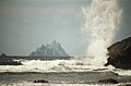
View of the island from the coast


See also
 In Spanish: Skellig Michael para niños
