
Valentia Island facts for kids
|
Native name:
Dairbhre
|
|
|---|---|

Knightstown Town clock
|
|

Valentia Island
Location in island of Ireland
Valentia Island
|
|
| Geography | |
| Location | Atlantic Ocean |
| Coordinates | 51°54′N 10°21′W / 51.9°N 10.35°W |
| Area | 25.7 km2 (9.9 sq mi) |
| Length | 11 km (6.8 mi) |
| Width | 3 km (1.9 mi) |
| Administration | |
| Province | Munster |
| County | Kerry |
| Largest settlement | Knightstown (pop. 156) |
| Demographics | |
| Population | 665 (2011) |
Valentia Island is a beautiful island off the coast of County Kerry in Ireland. Its Irish name is Dairbhre, which means "The Oak Wood". It is one of the most western points of Ireland.
The island is connected to the mainland by the Maurice O'Neill Memorial Bridge at Portmagee. You can also take a car ferry from Reenard Point to Knightstown. Knightstown is the island's main village. Another smaller village, Chapeltown, is about 3 kilometers (2 miles) from the bridge. About 665 people live on Valentia Island. The island is about 11 kilometers (7 miles) long and almost 3 kilometers (2 miles) wide.
Contents
What's in a Name?
The name Valentia Island sounds a bit like the Spanish city of Valencia. However, it actually comes from an old Irish name for a place on the island. This place was called An Bhaile Inse or Beal Inse. These names mean "mouth of the island" or "island in the mouth of the sound". It's thought that English and Spanish sailors might have changed the name to sound like the Spanish city. There's even a grave marker for Spanish sailors in the Catholic cemetery at Kylemore.
Island History

Valentia Island played a huge role in connecting Europe and North America. It was the starting point for the first successful transatlantic telegraph cable. This cable allowed messages to be sent across the Atlantic Ocean using electricity.
The first attempts to lay the cable in 1857 and 1858 didn't work. But after a lot of hard work, a successful cable was finally laid in 1866. It ran from Foilhommerum Bay on Valentia Island all the way to Heart's Content in Newfoundland, Canada. These transatlantic telegraph cables worked from Valentia Island for 100 years! They stopped operating in 1966.
The cable was also important for mapping. In 1866, scientists used the cable to accurately measure longitudes. Longitude helps us know how far east or west a place is. This was very important for safe navigation at sea.
In 1927, a famous pilot named Charles A. Lindbergh flew solo from New York to Paris. His first sighting of land in Europe was over Dingle Bay and Valentia Island. On his map, the island was even labeled Valencia!
In 1993, a student made an amazing discovery on the island. They found fossilized footprints of ancient creatures called tetrapods. These footprints were preserved in rocks that are about 385 million years old! This means they are some of the oldest signs of animal life on land. Imagine, a creature walked there when Ireland was near the equator!
More recently, in 2021, Valentia Island had another special visitor. It was the first time a walrus had ever been seen in Ireland!
Cool Places to Visit

Valentia Island is a great place for tourists because of its unique features and interesting history. It's easy to reach from the popular Ring of Kerry driving route.
- Geokaun Mountain and Fogher Cliffs: This is the highest mountain on Valentia Island. On its northern side, you can see amazing sea cliffs that are about 180 meters (600 feet) high.
- Glanleam House Gardens: On the northeast side of the island, you'll find Glanleam House with its amazing sub-tropical gardens. These gardens are special because they are protected from strong Atlantic winds and rarely get frost. This creates a very mild microclimate (a small area with different weather). Because of this, rare plants from places like South America, Australia, and New Zealand can grow here. You can even see the tallest tree ferns in Europe! The gardens are open to visitors.
- The Slate Quarry: This quarry reopened in 1998. It provided slates for famous buildings like the British Houses of Parliament.
- Heritage Centre: The island also has a heritage center. Here, you can learn all about the island's geology, its human history, and its industries. There are exhibits about the Cable Station and the Marine Radio Station.
- The Telegraph Field: This is the historic spot where the first permanent communication link between Europe and North America was made. It's where the transatlantic telegraph cables started their journey across the ocean.
Island Climate
Valentia Island has an oceanic climate. This means it has mild winters and cool summers. Even though it's on the same latitude as places like Newfoundland in Canada, it has much milder weather. This is because of the warm Gulf Stream current and winds from the west. Snow and frost are very rare here. This is why many sub-tropical plants can grow on the island.
Sports and Activities
Valentia Young Islanders GAA is the local club for Gaelic Athletic Association sports.
Valentia is also a popular spot for fishing. The waters around Valentia hold Irish records for catching certain types of fish. These include the conger eel, red sea bream, Ray's bream, and lesser spotted dogfish.
Gallery
-
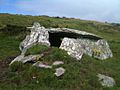
Dolmen Rock, western slope of Mt. Geokaun
-
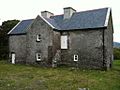
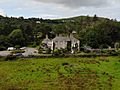
Balleyhearney House, Balleyhearney East. 'Famine Era' hospital adjacent to the Knights' Wood.
-
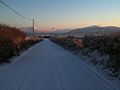
Rare snowy day, Main Road, Valentia Island looking toward Knightstown, Valentia Harbour and Cahersiveen
-
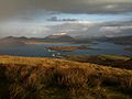
Portion of the view from the summit of Mt. Geokaun ("yo-kawn"). Valentia Harbour and Cahersiveen are in the background
-
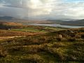
Portion of the view from the summit of Mt. Geokaun ("yo-kawn"). Valentia Harbour and Letter are in the background
-
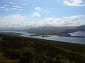
View from Culloo Rock. Dingle Peninsula, Dingle Bay and the north shore of Valentia Island (including Fogher Cliffs) are in the background.
-
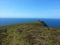
Bray Head view looking west with Skellig Islands in distance
-
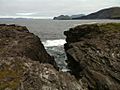
View of Portmagee Channel looking south-east from Bray Head
-
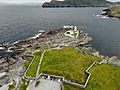
Valentia lighthouse and surrounding fortifications
-
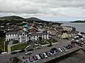
Knightstown
-
Glanleam House
-
Valentia Slate Quarry


See also
 In Spanish: Isla de Valentia para niños
