
Dingle Way facts for kids
Quick facts for kids Dingle Way |
|
|---|---|

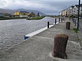
Section of the Dingle Way near Smerwick Harbour and Ballydavid Head
|
|
| Length | 162 km (101 mi) |
| Location | County Kerry, Ireland |
| Designation | National Waymarked Trail |
| Trailheads | Tralee |
| Use | Hiking |
| Elevation gain/loss | +2,590 m (8,497 ft) |
| Highest point | Shoulder of Mount Brandon (640 m (2,100 ft)) |
| Difficulty | Strenuous |
| Season | Any |
| Sights | Dingle Peninsula |
| Surface | Mountain, field and cliff paths; roads; beaches |
| Website | www.thedingleway.ie |
| Map overview | |
 |
|
The Dingle Way (which is called Slí Chorca Dhuibhne in Irish) is a super cool long-distance walking trail. It goes all the way around the amazing Dingle Peninsula in County Kerry, Ireland. This trail is like a big circle, about 162 kilometers (101 miles) long. Most people start and finish it in Tralee and take about eight days to walk the whole thing. It's known as a National Waymarked Trail. This means it's a special, well-marked path for hikers.
Contents
Discovering the Dingle Way
The Dingle Way is a fantastic adventure for anyone who loves walking and nature. It takes you through some of Ireland's most beautiful scenery. You'll see stunning coastlines, green mountains, and charming villages. It's a great way to explore the history and culture of the Dingle Peninsula.
Starting Your Dingle Way Journey
Your adventure on the Dingle Way begins in Tralee. The path first follows an old ship canal's towpath. A towpath is a path next to a canal where horses used to pull boats. This leads you to a village called Blennerville. After that, you'll walk on roads for a bit. Then, the trail starts to climb up. You'll find yourself on a mountain track. This track runs along the northern side of the Slieve Mish Mountains.
Walking Towards the Coast
From the mountains, the trail goes downhill. You'll head towards Tralee Bay and the village of Camp. The next parts of the walk are mostly on smaller roads. These are called boreens in Ireland, which are narrow country lanes. You'll pass through places like Annascaul (via Inch Strand) and Dingle (via Lispole).
Exploring Coastal Paths
As you get closer to Dunquin, the trail gets really exciting. It follows a path right along the cliffs around Slea Head. Imagine walking with the ocean crashing below! The section between Dunquin and Ballycurrane mixes things up. You'll walk on roads, beautiful beaches, and more cliff paths.
Reaching the Highest Point
One of the most challenging parts of the Dingle Way is next. The trail climbs up between Brandon and Masatiompan mountains. This is the highest point on any National Waymarked Trail in Ireland. You'll reach an elevation of about 640 meters (2,100 feet)! From this high point, the trail goes down. It leads you to Brandon village. Then, it continues to the village of Cloghane.
The Final Stretch of the Trail
From Cloghane, you'll walk along Fermoyle Strand. This is Ireland's longest beach, which is pretty cool! It takes you to a place called Fahamore. After that, you'll follow roads to the village of Castlegregory. The very last part of the Dingle Way follows the coastline back to Camp. From Camp, you'll retrace your steps back to Tralee. This completes your amazing circular journey!
Why Hike the Dingle Way?
The Dingle Way is a very popular trail. Lots of people enjoy walking parts of it for a day. Many also choose to do the whole multi-day adventure. Experts have even suggested making it an even better trail. They want it to meet international standards for amazing long-distance walks. They also think it would be great to add smaller loop walks. These would branch off the main trail, giving you more options to explore.
- Views along the Dingle Way
-
The old ship canal between Tralee and Blennerville
-
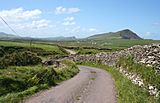
Tarmac road section, looking towards Ballydavid Head
-
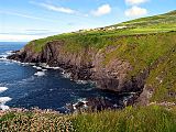
Cliffs near Slea Head
-
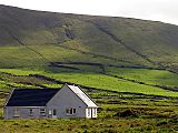
Hillside pasture and residence


