Kerry Way facts for kids
Quick facts for kids Kerry Way |
|
|---|---|
 |
|
| Length | 214 kilometres (133 miles) |
| Location | County Kerry, Ireland |
| Designation | National Waymarked Trail |
| Trailheads | Killarney |
| Use | Hiking |
| Elevation gain/loss | 5,310 m (17,421 ft) |
| Highest point | Windy Gap (385 m (1,263 ft)) |
| Difficulty | Strenuous |
| Season | Any |
| Sights | Iveragh Peninsula |
| Website | http://www.kerryway.com/ |
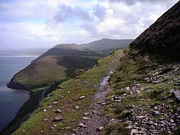
The Kerry Way (called Slí Uíbh Ráthaigh in Irish) is a super long walking path in County Kerry, Ireland. It's like a giant circle, about 214 kilometers (133 miles) long. This amazing trail starts and finishes in a town called Killarney. Most people take about 8 to 10 days to walk the whole thing.
The Kerry Way is known as a National Waymarked Trail. This means it's an official, well-marked path for walkers. It's looked after by different groups, including the Kerry County Council. The path goes all the way around the Iveragh Peninsula, which is a beautiful area of land sticking out into the ocean. Think of it as a walking version of the famous "Ring of Kerry" road trip! It's actually the longest official walking trail in all of Ireland.
Discovering the Kerry Way's Past
The idea for the Kerry Way first came up in 1982. Some people from a climbing club and a group called An Taisce helped create it. A man named Seán Ó Súilleabháin was in charge. He got the idea after hearing a talk about old roads and paths in southwest Ireland. He realized that many old paths could be joined together to make a big route around Kerry.
The first part of the trail, from Killarney to Glenbeigh, opened in 1985. A very important Irish politician named Dick Spring, who was the Tánaiste (like a deputy prime minister), officially opened it. The Kerry Way was only the second long-distance trail to open in Ireland! The full path was finished in 1989. Another politician, Frank Fahey, who was a Minister for Youth and Sport, opened the complete trail.
Building the trail cost about £60,000 (Irish Punt, the old money). Workers put in over 200 stiles (steps over fences) and six footbridges. They also added lots of signs to help people find their way.
In 2010, a study looked at all the National Waymarked Trails. It found that the Kerry Way was one of the most popular trails. The study suggested that it should be made even better to meet international standards for amazing long-distance trails.
The Irish name for the trail, Slí Uíbh Ráthaigh, means "Iveragh Way." This name comes from the Iveragh Peninsula that the trail circles.
Exploring the Kerry Way's Route
The Kerry Way used to start a little outside Killarney, but now it begins right in the center of the town.
The first part of the path takes you through the beautiful grounds of Muckross House. This is like the entrance to Killarney National Park. You'll walk past the shores of Lough Leane and Muckross Lake before reaching the stunning Torc Waterfall.
From Torc, the trail follows an old road called the Old Kenmare Road. It crosses a valley called Esknamucky Glen to reach the Black Valley. As you walk through the Black Valley, you'll see the huge MacGillycuddy's Reeks mountains, including Carrauntoohil, which is the tallest mountain in Ireland!
The path then goes through Cummeenduff Glen to Bridia Valley. After that, it follows the Lack Road over another mountain pass into Derrynafeana Glen. You'll reach Lough Acoose and then follow a road to the village of Glencar.
From Glencar, the trail follows the Caragh River valley. It then goes around Seefin Mountain to reach Glenbeigh. There are two ways to go around Seefin: a shorter path through Windy Gap or a longer one above Caragh Lake that looks over Dingle Bay.
The Way then climbs up and follows the hills overlooking Dingle Bay until it gets to Drung Hill. Here, it turns inland towards Foilmore. There's an 11-kilometer (7-mile) side path you can take from Foilmore to Cahersiveen.
From Foilmore, the route crosses two hills to reach the village of Waterville. From Waterville, you have two choices to get to Caherdaniel: a path along the coast around Farraniargh Mountain or an inland path that crosses the Capall River and goes over mountains through another Windy Gap.
An old coach road takes the Way to Sneem. Then, a trail connects Sneem and Kenmare, following the coast above Kenmare River.
The very last part of the trail crosses the mountains between Kenmare and Killarney, going through yet another Windy Gap! It then joins back up with the path you took at the beginning, going through Muckross again, until you reach the end in Killarney.
Connecting with Other Trails
A part of the Kerry Way, the section from Kenmare to Killarney, is actually part of a much bigger walking route called the European walking route E8. This super long route starts in Dursey Island in County Cork, Ireland, and goes all the way to Istanbul in Turkey!
The E8 also connects to other trails in Ireland, like the Beara Way from Kenmare and the Blackwater Way.
 | Delilah Pierce |
 | Gordon Parks |
 | Augusta Savage |
 | Charles Ethan Porter |

