
Dursey Island facts for kids
|
Native name:
Oileán Baoi
|
|
|---|---|

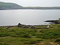
Dursey Island as seen from a hiking path on the mainland
|
|

Dursey Island
Location in island of Ireland
|
|
| Geography | |
| Location | Beara Peninsula |
| Coordinates | 51°36′N 10°12′W / 51.600°N 10.200°W |
| Area | 5.6 km2 (2.2 sq mi) |
| Length | 6.5 km (4.04 mi) |
| Width | 1.5 km (0.93 mi) |
| Highest elevation | 252 m (827 ft) |
| Administration | |
|
Ireland
|
|
| Province | Munster |
| County | Cork |
| Demographics | |
| Population | 4 (2016) |
| Additional information | |
| Official website | DurseyIsland.ie |
Dursey Island is a small island located at the very end of the Beara Peninsula in County Cork, Ireland. Its Irish name is Oileán Baoi. The island is about 6.5 kilometers (4 miles) long and 1.5 kilometers (1 mile) wide.
Dursey Island is separated from the mainland by a narrow stretch of water called Dursey Sound. This sound has very strong currents, like a fast-moving river. Only a few people live on the island permanently, usually around four to six residents. It is connected to the mainland by Ireland's only cable car, which is a unique way to travel! There are no shops, pubs, or restaurants on Dursey Island. It's a quiet place!
Contents
Exploring Dursey Island
Dursey Island has three main areas, or "townlands": Ballynacallagh, Kilmichael, and Tilickafinna. The highest point on the island is 252 meters (827 feet) high. Around Dursey Island, there are also some interesting rocks and smaller islands.
Bull Rock
Off the western tip of Dursey Island, you'll find three large rocks: Bull Rock, Cow Rock, and Calf Rock. The Bull Rock Lighthouse stands tall on Bull Rock. It was built in 1888 and became automatic in 1991. Before that, people actually lived on Bull Rock to operate the lighthouse!
Calf Rock
A lighthouse once stood on Calf Rock too, but it was destroyed in a big storm in 1881. You can still see what's left of it today.
Cow Rock and Wildlife
Cow Rock is a special place for many kinds of seabirds. They build their nests there. In the waters around Dursey Island, you might also spot amazing sea creatures like dolphins, whales, and even basking sharks!
A Look Back in Time
Dursey Island has a long and interesting history, with signs of people living there for thousands of years.
Ancient Sites
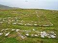
Archaeologists have found ancient sites on the island. These include special stones called bullaun stones and cup-marked stones in Ballynacallagh. There are also remains of old huts and stone circles.
Dursey Castle and the Massacre
More recent historical sites can be seen at Ballynacallagh. Here, you'll find the ruins of an old church and a graveyard. There was also a castle on a small island nearby called Oileán Beag. In 1602, this castle was used by the O'Sullivan Beare family.
During a war called the Nine Years' War, the English army attacked and destroyed the castle. Sadly, all 300 people on the island were killed in what is known as the Dursey Massacre. After this terrible event, Donal Cam O'Sullivan Beare led his remaining people on a long journey across Ireland to find safety. Very little of the castle remains today.
Napoleonic Signal Tower
On the highest point of Dursey Island, at Tilickafinna, you can see the ruins of a signal tower. This tower was built during the Napoleonic Wars (early 1800s). It was used to send signals and watch for enemy ships. It has been a ruin since the mid-1800s.
World War II History
During World War II, Ireland was neutral. To let pilots know they were flying over a neutral country, a large sign saying "Éire" (the Irish name for Ireland) was built and painted white near the signal tower. In July 1943, a German Junkers Ju 88 plane crashed nearby in thick fog, and all its crew members died.
Visiting Dursey Island

Dursey Island is a popular spot for day trips and walks, especially in the summer. A special walking path, part of the Beara Way, goes around the island. This walk is also the starting point for Europe's E8 European long distance path, which stretches all the way to Istanbul, Turkey!
The cable car that crosses Dursey Sound is Ireland's only cable car. It's also one of the very few cable cars in Europe that crosses the sea. It's a big attraction for visitors and helps the few island residents get to the mainland.
Dursey Sound is also a "signature discovery point" along the Wild Atlantic Way. This is a famous coastal route that runs along Ireland's Atlantic coastline. Even though there are no shops or restaurants, you can rent holiday homes on the island if you want to stay longer.
Images for kids
-
Ecclesiastical ruins and graveyard at Ballynacallagh
-
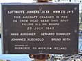
Ju 88 memorial sign on the mainland next to Dursey cable car
-
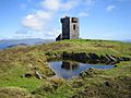
Napoleonic era signal tower
-
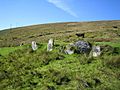
Standing stones
-
Remains of World War II "EIRE" neutrality sign
-
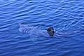
A basking shark feeds in the Dursey Sound.


,_Standing_stone_-_geograph.org.uk_-_284000.jpg)


