
Istanbul facts for kids
Quick facts for kids
Istanbul
İstanbul
|
|
|---|---|
|
Metropolitan municipality
|
|
| Istanbul Metropolitan Municipality | |

Clockwise from top: The Golden Horn between Galata and the Seraglio Point; Maslak financial district; İstiklal Avenue; Kuleli Military High School; and Sultan Ahmed Mosque
|
|
| Country | Turkey |
| Region | Marmara |
| Province | Istanbul |
| - Byzantium | c. 660 BC |
| - Constantinople | 330 AD |
| - Istanbul | 1930 (officially) |
| Districts | 39 |
| Area | |
| • Metro | 5,343 km2 (2,063 sq mi) |
| Population
(2012)
|
|
| • Metropolitan municipality | 13,854,740 |
| • Rank | 1st Turkey, 2nd World |
| • Density | 2,593/km2 (6,720/sq mi) |
| Demonym(s) | Istanbulite(s) (Turkish: İstanbullu(lar)) |
| Time zone | UTC+2 (EET) |
| • Summer (DST) | UTC+3 (EEST) |
| Postal code |
34000 to 34850
|
| Area code(s) | (+90) 212 (European side) (+90) 216 (Asian side) |
Istanbul is the biggest city in Turkey. It was known as Constantinople and Byzantium in the past. Istanbul is a very important place for business, culture, and history.
It's a special city because it's in both Europe and Asia. The Bosporus strait splits the city, connecting the Sea of Marmara and the Black Sea. The main business and historical areas are on the European side. About one-third of the people live on the Asian side.
Istanbul is one of the world's most populated cities. Around 15 million people live there. Many people see Istanbul as a bridge between the East and the West.
The city was first settled around 660 BCE. It was called Byzantion back then. Later, in 330 CE, it became Constantinople. It was an important capital city for almost 16 centuries. It served as the capital for the Roman/Byzantine, Latin, and Ottoman empires.
Istanbul was very important for Christianity during Roman and Byzantine times. Then, in 1453, the Ottomans conquered the city. It became a strong Islamic center and the home of the Ottoman Caliphate.
Istanbul's location is very strategic. It's on the historic Silk Road and has sea routes between the Black Sea and the Mediterranean. This has made it a city with people from many different backgrounds. After 1923, when the Turkish Republic was formed, Ankara became the new capital. But Istanbul has become very important again.
The city's population has grown a lot since the 1950s. Many people from across Anatolia have moved there. Istanbul now hosts many art, music, and film festivals. Its transportation system has also improved a lot.
In 2015, about 12.56 million tourists visited Istanbul. This made it the world's fifth most popular place for tourists. The historic center of Istanbul is a UNESCO World Heritage Site. The Beyoğlu district, across the Golden Horn, is a lively place for culture and fun. Istanbul is seen as a global city with a fast-growing economy. It is home to many Turkish companies and media groups.
Contents
History of Istanbul
Istanbul has a very long and rich history. It was first called Byzantion in Greek, or Byzantium in Latin.
Early Settlements
Archeologists have found signs of human life in Istanbul from as far back as 6,000 BCE. These early settlements were important for spreading farming from the Near East to Europe. The first known settlement on the Asian side was Fikirtepe. It dates from 5500 to 3500 BCE.
From Byzantium to Constantinople
Greek settlers from Megara founded Byzantium in 667 BC. They named it after their king, Byzas. In 196 AD, the Romans damaged the city. Then, Emperor Septimius Severus rebuilt it.
Constantine the Great liked the city's location. In 330 AD, he moved the capital of the Roman Empire from Rome to Byzantium. He renamed it New Rome or Constantinople, after himself.
Byzantine and Ottoman Empires
When the Roman Empire split, Constantinople became the capital of the East Roman Empire, known as the Byzantine Empire. The famous Hagia Sophia was built there. Constantinople was a major center for politics, culture, religion, and trade in Europe.
Even though Crusaders captured it for a while, it remained powerful. Finally, in 1453, the Ottoman Turks conquered the city. After the Ottoman Empire ended, the Republic of Turkey was formed. Its capital became Ankara.

Geography of Istanbul
Istanbul is in northwestern Turkey. It sits on the Bosporus Strait. This strait is the only way for ships to go from the Black Sea to the Mediterranean through the Sea of Marmara.
Strategic Location
Historically, Istanbul's location was perfect for trade and defense. The meeting point of the Sea of Marmara, the Bosporus, and the Golden Horn offered great protection. It also acted as a natural checkpoint for trade.
The city includes several beautiful islands. These are Büyükada, Heybeliada, Burgazada, Kınalıada, and five smaller ones. Istanbul's shoreline has grown over time. Some areas, like Caddebostan, are built on land created by filling in parts of the sea. The city covers about 5,343 square kilometers (2,063 sq mi).
Hills and Earthquakes
Many people believe Istanbul is built on seven hills, but it actually has more than 50 hills. The tallest hill in Istanbul is Aydos, which is 537 meters (1,762 ft) high.
Istanbul is near the North Anatolian Fault. This fault causes many earthquakes. While the fault doesn't go right through the city, there's a chance of a strong earthquake (magnitude 7 or higher) happening in the 21st century. Earthquakes in 1766 and 1894 were caused by this fault. Because of this risk, Istanbul has been improving its buildings. Since 2012, over 500,000 old buildings have been replaced. The city also updates its building codes often, making sure new buildings are very safe.

Architecture in Istanbul
Istanbul is famous for its amazing buildings from the Byzantine and Ottoman times. Even though it's a modern Turkish city, it still has many old Roman, Byzantine, Christian, Muslim, and Jewish structures.
Ancient and Roman Structures
The oldest known human settlement on the European side of Istanbul is in the Yenikapı area. It dates back to about 6500 BCE. On the Asian side, the Fikirtepe Mound is the oldest, from around 5500-3500 BCE.
One of the oldest monuments is the Obelisk of Thutmose III. This tall, red granite pillar is 31 meters (100 ft) high. It came from the Temple of Karnak in Luxor, Egypt. It was brought to Istanbul in 390 CE and placed in the Hippodrome.
Another old monument is the Serpent Column from 479 BCE. It was brought from Delphi, Greece, in 324 CE. It was originally part of a Greek monument celebrating a victory against the Persian Empire.
The Column of Constantine was built in 330 CE to mark the founding of the new Roman capital. It was topped with a statue of Constantine the Great.
Byzantine Buildings
You can find traces of the Byzantine era all over Istanbul. There are old churches like the Hagia Irene and the Chora Church. There are also palaces like the Great Palace of Constantinople. Other public places include the Hippodrome and the Basilica Cistern. The Aqueduct of Valens is another impressive Byzantine structure.
The Hagia Sophia is the most famous Byzantine building. It has a huge dome, 31 meters (100 ft) wide. It was the world's largest cathedral until it became a mosque in the 15th century. Its tall minarets were added then. In 1935, it became a museum. However, in July 2020, it was changed back into a mosque.

Ottoman Architecture
Over four centuries, the Ottomans changed Istanbul's look. They built many tall mosques and beautiful palaces. The Sultan Ahmed Mosque (also known as the Blue Mosque) is a famous landmark. It faces the Hagia Sophia. The Süleymaniye Mosque was designed by Mimar Sinan, a very famous Ottoman architect. He designed many of the city's well-known mosques and other buildings.
Some of the oldest Ottoman buildings are the Anadoluhisarı and Rumelihisarı fortresses. These helped the Ottomans during their siege of the city.


Topkapı Palace, built in 1465, was the first main home and government center for the Ottoman sultans. It grew over centuries with additions, blending different styles. In 1853, the sultans moved to the Dolmabahçe Palace. Topkapı Palace became a museum in 1924.
Other important Ottoman mosques include Fatih Mosque, Bayezid Mosque, and Yeni Mosque. Later, European styles influenced Ottoman architecture. For example, the Nuruosmaniye Mosque shows this change. Areas around İstiklal Avenue have grand European-style buildings.


Places to Visit in Istanbul
Istanbul has many amazing places to explore:
- Topkapı Palace
- Hagia Sophia
- The Grand Bazaar, Istanbul
- The Spice Bazaar, Istanbul
- Sultan Ahmed Mosque (Blue Mosque)
- Suleiman Mosque
- Istiklal Avenue
- Basilica Cistern
- Bulgarian St Stephen Church (Bulgarian Iron Church)
- Golden Horn
- Galata Tower
- Prince's Islands
- Dolmabahçe Palace
- Taksim Square
- Beyoglu
- Bebek fish restaurants
Public Transportation
Istanbul has a large public transportation system. It includes trains, trams, funiculars, metro lines, buses, and ferries. You can pay for all these with a special card called the Istanbulkart.


Trams and Funiculars
Trams in Istanbul started in 1872, pulled by horses. Electric trams were used later but stopped in the 1960s. In the 1990s, trams came back. Now, there's a nostalgic tram route and a faster modern tram line. The modern tram carries about 265,000 passengers every day.
The Tünel opened in 1875. It's the world's second-oldest underground rail line. It still takes passengers between Karaköy and İstiklal Avenue. A newer funicular line opened in 2006, connecting Taksim Square and Kabataş.
Metro and Commuter Rail
The Istanbul Metro has ten lines. Some are on the European side, and some are on the Asian side. More lines are being built. The two sides of the metro are connected under the Bosporus by the Marmaray Tunnel. This tunnel opened in 2013. It was the first rail connection between Europe and Asia in Istanbul.


The Marmaray tunnel and suburban railways form a long commuter rail line called B1. It goes from Halkalı on the European side to Gebze on the Asian side. This line is 76.6 kilometers (47.6 mi) long and fully opened in 2019.
Buses are also a very common way to get around. They carry about 2.2 million passengers daily. The Metrobus is a special bus system with its own lanes. It even crosses the Bosporus Bridge.
Images for kids
-
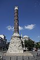
Column of Constantine
-
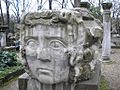
This large keystone might have belonged to a triumphal arch at the Forum of Constantine.
-
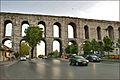
The Aqueduct of Valens was started by Emperor Constantius II and finished in 373 by Emperor Valens.
-
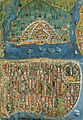
Map of Istanbul in the 16th century by Matrakçı Nasuh
-
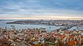
View of the Golden Horn and the Seraglio Point from Galata Tower
-
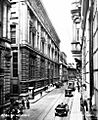
A view of Bankalar Caddesi (Banks Street) in the late 1920s.
-

Microclimates of Istanbul based on the Köppen–Geiger system.
-
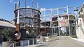
'Müze Gazhane' in Kadıköy is Turkey's first climate change museum.
-
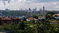
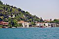
A view of Levent from Kanlıca across the Bosporus.
-
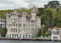
Yalı residences along the Bosporus are now homes in some of Istanbul's fancy neighborhoods.
-
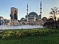
A view of Taksim Square with the Republic Monument (1928) and Taksim Mosque.
-
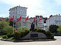
Statue of Mustafa Kemal Atatürk in Büyükada, the largest of the Prince Islands.
-
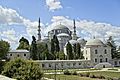
The Süleymaniye Mosque (1550–1557) was designed by Mimar Sinan.
-
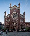
The Church of St. Anthony of Padua, Istanbul on İstiklal Avenue.
-
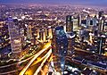
A view of Levent financial district from Istanbul Sapphire.
-
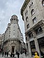
Deutsche Orientbank AG (1906) in Sirkeci.
-
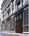
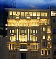
Ottoman Central Bank Head Office (1892) on Bankalar Caddesi.
-
Yalı houses on the Bosporus are often seen in Turkish TV shows.
-
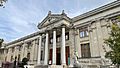
The Istanbul Archaeology Museums, founded in 1891, are Turkey's oldest modern museum.
-
Pera Museum in Beyoğlu.
-
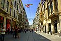
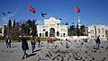
Around three million people visit İstiklal Avenue on weekends.
-
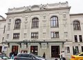
Süreyya Opera House.
-
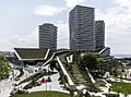
Zorlu Center, designed by EAA and Tabanlıoğlu Architects.
-
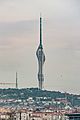
Küçük Çamlıca TV Radio Tower (369 m or 1,211 ft) is the tallest building in the city.
-
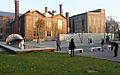
Main entrance gate of Istanbul University, the city's oldest Turkish school.
-
The Silahtarağa Power Station, now the art museum SantralIstanbul.
-
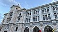
The Istanbul Main Post Office in Sirkeci, designed by Vedat Tek.
-
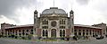
The İstanbul Sirkeci Terminal building, built between 1888 and 1890, was the eastern end of the Orient Express.
-
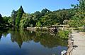
Atatürk Arboretum is a forest and plant collection in Bahçeköy, Sarıyer.
-
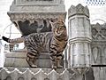
Street cats in the city.


.jpg)


.jpg)


.jpg)


.jpg)

See also
 In Spanish: Estambul para niños
