
Bosporus facts for kids
The Bosporus or Bosphorus is a narrow waterway that separates the continent of Europe from Asia. It is located in Turkey and connects the Black Sea with the Sea of Marmara. Think of it like a natural river that links two bigger bodies of water!
This strait is about 30 km long. At its widest point, near the northern entrance, it's about 3,700 metres across. At its narrowest, between Kandilli and Aşiyan, it's only about 700 metres wide. The water depth in the middle of the strait can be anywhere from 36 to 124 metres deep.
The shores of the Bosporus are very busy because the big city of Istanbul is right next to it. Many people live and work here. To help people cross between Europe and Asia, several bridges and tunnels have been built over and under the strait.


Contents
Why the Bosporus is Important
The Bosporus is a very important waterway for many reasons. It is a natural boundary between two continents, Europe and Asia. This makes it a special place where different cultures meet.
A Busy Waterway
For thousands of years, the Bosporus has been a vital route for ships. It allows vessels to travel between the Black Sea and the Mediterranean Sea. This means it's important for trade and travel. Many ships, from cargo vessels to passenger ferries, use this strait every day.
Connecting Continents
Because the Bosporus separates Europe and Asia, it has always been a key location. The city of Istanbul sits on both sides of the strait. This makes Istanbul the only major city in the world that is on two continents!
Crossing the Bosporus
To make it easier for people and goods to move between the European and Asian sides of Istanbul, several amazing structures have been built across the Bosporus.
Famous Bridges
There are three main suspension bridges that span the strait. These bridges are huge and impressive:
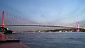
- The Bosphorus Bridge (also known as the 15 July Martyrs Bridge) was the first to be built. It opened in 1973.
- The Fatih Sultan Mehmet Bridge was the second bridge, completed in 1988. It is named after an Ottoman Sultan.
- The Yavuz Sultan Selim Bridge is the newest and third bridge. It opened in 2016 and is one of the widest suspension bridges in the world.
Underground Tunnels
Besides bridges, there are also tunnels that go under the Bosporus. These tunnels help trains and cars cross the strait quickly. They are engineering marvels that allow for even more connections between the two continents.
History of the Bosporus
The Bosporus has played a big role in history. Many ancient civilizations and empires have lived along its shores. Its strategic location made it important for defense and trade.
Ancient Times
In ancient times, the Bosporus was a natural barrier and a gateway. It was important for controlling trade routes. Many castles and forts were built along its banks to protect the strait. You can still see some of these historic structures today, like the Rumelihisarı and Anadoluhisarı castles.
Modern Importance
Today, the Bosporus continues to be a vital part of global shipping. It is also a beautiful place for tourism. Many people enjoy boat tours along the strait to see Istanbul's famous landmarks and historic waterfront houses.
Images for kids
-

Aerial view of the Bosporus taken from its northern end near the Black Sea (bottom), looking south (top) toward the Marmara Sea, with the city center of Istanbul visible along the strait's hilly banks.
-
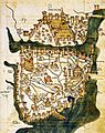
Map of Constantinople (modern-day Istanbul), designed in 1422 by Florentine cartographer Cristoforo Buondelmonti. This is the oldest surviving map of the city, and the only surviving map that predates the Turkish conquest of 1453. The Bosporus is visible along the right-hand side of the map, wrapping vertically around the historic city.
-
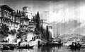
The Bosphorus, with the Castles of Europe & Asia. 19th-century engraving by Thomas Allom. The castles are Rumelihisarı and Anadoluhisarı, respectively. The original is a watercolor available in the online collection of the Victoria and Albert Museum.
-

Modern (2012) view of the European side of Istanbul from the southern entrance to the Bosphorus
-
Bosphorus Bridge, the first to be built across the Bosphorus, completed in 1973
-
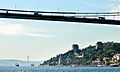
Fatih Sultan Mehmet Bridge, the second crossing built in 1988, looking from the Asian side towards the Rumelian Castle on the Bosphorus
-

Yavuz Sultan Selim Bridge, the third and most recent crossing, in September 2016. The bridge was opened on 26 August 2016.
-
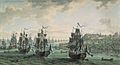
Russian fleet under the command of Admiral Fyodor Ushakov, sailing through the Bosporus
-
The Rumelian Castle on the Bosphorus, with both suspension bridges which span the strait
-
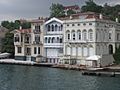
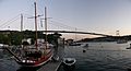
Ottoman era waterfront houses on the Bosphorus
-
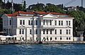
The yalı of Ahmet Rasim Pasha

_by_Florentine_cartographer_Cristoforo_Buondelmonte.jpg)


.jpg)


_on_the_Bosphorus,_Turkey_001.jpg)
See also
 In Spanish: Bósforo para niños
