River Laune facts for kids
Quick facts for kids River Laune |
|
|---|---|

River Laune at Killorglin
|
|
| Native name | An Leamhain |
| Country | Ireland |
| Physical characteristics | |
| River mouth | Atlantic Ocean via Castlemaine Harbour |
| Length | 23 kilometres (14 mi) |
| Basin features | |
| Basin size | 829 square kilometres (320 sq mi) |
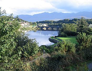
The River Laune (in Irish: An Leamhain) is a river in County Kerry, Ireland. It starts from Lough Leane, one of the beautiful Lakes of Killarney. The river flows through places like Beaufort and past Ballymalis Castle. It then goes through the town of Killorglin. Finally, it flows into the sea at Castlemaine Harbour and then out into Dingle Bay. The River Laune is a very popular spot for salmon and trout fishing.
The River Laune is about 23 kilometers (14 miles) long. If you add the length of the River Flesk, which flows into Lough Leane, the total length is about 68 kilometers (42 miles). The river carries a lot of water, with an average flow rate of 43 cubic meters per second.
The River Laune helps drain Lough Leane into the sea at Castlemaine Harbour. It carries most of the rainwater from the MacGillycuddy's Reeks, which is Ireland's highest mountain range. Many small streams from the south side of these mountains flow into Killarney’s Upper Lake. This water then moves down to Lough Leane. As the River Laune leaves Lough Leane, it gets more water from two other rivers. These are the River Loe from the Gap of Dunloe and the Gaddagh River from the heart of the Reeks. Another river, the Cottoners River, also adds rainwater from the west of the mountains.
Contents
Protecting the Land from the Sea
For a long time, people have built special walls along the River Laune. These walls are called embankments. They stop the sea from flooding the low-lying land around Castlemaine Harbour. There are over 40 kilometers (25 miles) of these embankments in the area.
Why Embankments Were Built
These embankments were built around 1808. At that time, the British government needed new ways to get hemp. Hemp was used to make sailcloth for their navy. They thought they could grow hemp in Ireland if they drained the wet boglands. This would help them avoid relying on other countries for supplies.
In 1811 and 1812, a person named Alexander Nimmo mapped out a large area of land. He found over 30,700 hectares (76,000 acres) that could be used. About 7,000 hectares (17,000 acres) of this land was near the sea. This included the area around the Laune River and Castlemaine Harbour.
How the Embankments Work
The embankments are made of stone and earth. They are between 1 meter (3 feet) and over 5 meters (16 feet) high. They stop high tides from flooding the land. There are also special gates called sluice gates. These gates let water drain out when the tide is low. They also stop the rising tide from coming in and flooding the land.
The embankments run from Tullig, near Cromane, to Killorglin. They also go along both sides of the Maine River and the north side of Castlemaine Harbour. Many parts of these old banks are still strong today. Some areas have been repaired with large rocks and concrete.
You can walk along parts of these old embankments today. The Killorglin river bank walk and the Astellas river bank walk are good examples. They are located downstream of the Metal Bridge.
Killorglin County Bridge
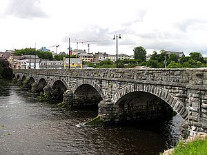
The Killorglin County Bridge was built in 1885. It replaced an older bridge that was made of wood. The old wooden bridge would sometimes get covered by water during very high tides.
The current bridge is made from local limestone. This stone was brought by horse and cart from Steelroe Quarries, which is about 1 kilometer (0.6 miles) away. Skilled stonecutters shaped each stone by hand. They used these stones to build the bridge's supports, its eight stone arches, and its side walls. Each arch is about 15 meters (50 feet) long. This makes the total length of the bridge about 123 meters (400 feet).
Art and History on the Laune
The area around the River Laune in Killorglin also celebrates local history and art.
Puck Fair Statue
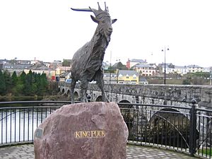
In 2001, the Killorglin Millennium Committee built a special area called "Faiche Ri Na Phoic." This means "The lawn of King of Puck." They also put up the Puck Statue at the northern end of the bridge. This statue of a goat is a symbol of the famous Puck Fair. This fair has been held in Killorglin every year since the early 1600s. It takes place on August 10th, 11th, and 12th.
Puck Poets' Corner
In 2010, the "Puck Poets' Corner" was added. This area displays poems and verses about Killorglin. These poems were written by different people, with some dating back to 1876. Famous poets featured here include Edso Crowley, Sigerson Clifford, Johnny Patterson, and Peter Joy.
See also
 In Spanish: Río Laune para niños
 | Jessica Watkins |
 | Robert Henry Lawrence Jr. |
 | Mae Jemison |
 | Sian Proctor |
 | Guion Bluford |


