Conor Pass facts for kids
Quick facts for kids Conor Pass |
|
|---|---|
| An Chonair | |

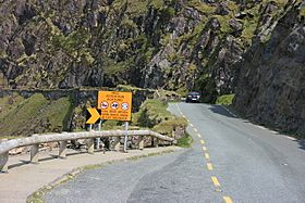
Road warnings on the Conor Pass
|
|
| Elevation | 456 m (1,496 ft) |
| Traversed by | Road |
| Location | County Kerry, Ireland |
| Range | Mountains of the Central Dingle Peninsula |
| Coordinates | 52°10′55″N 10°12′26″W / 52.18194°N 10.20722°W |
The Conor Pass (also spelled Connor Pass) is a famous mountain pass in Ireland. Its Irish name is An Chonair. It is one of the highest points in Ireland that you can reach by car.
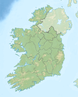
You can find the Conor Pass on the R560 road. This road is in County Kerry, which is in the south-west of Ireland.
What is the Conor Pass?
A mountain pass is like a natural path or road through a mountain range. The Conor Pass is 456 meters (about 1,496 feet) high. It connects two important places on the Dingle Peninsula.
It links the town of Dingle in the south-west to Brandon Bay and Castlegregory in the north-east. The Dingle Peninsula is a beautiful area known for its stunning views.
Driving the Conor Pass
The road over the Conor Pass is very winding and narrow. It is mostly a single lane, so drivers need to be careful. Because of its twists and turns, it is not a good road to drive on in bad weather.
Even with its challenges, many people think this drive is one of the most beautiful in Ireland. The road winds around steep cliffs. It also passes by high lakes called corrie lakes, which were formed by glaciers.
To keep everyone safe, very large vehicles are not allowed on the pass. Vehicles weighing more than two tonnes (about 4,400 pounds) cannot use this road. This rule helps prevent problems when cars try to pass each other.
Cycling the Conor Pass
The Conor Pass is also very popular with cyclists. Riding a bike up to the pass is known as one of the most famous and difficult climbs in Ireland. It is a big challenge for many cyclists.
 | Audre Lorde |
 | John Berry Meachum |
 | Ferdinand Lee Barnett |


