
List of Irish counties by area facts for kids
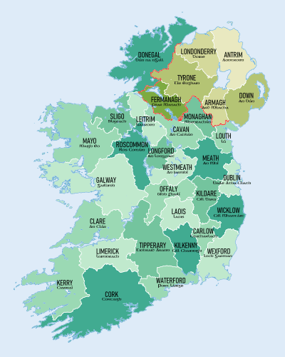
Ireland is an island with a rich history, and it's divided into smaller areas called counties. Think of them like different regions or districts within a country. This page lists all the counties of Ireland, from the biggest to the smallest, based on their total land area. You'll see that counties in the Republic of Ireland are written normally, while those in Northern Ireland are shown in italic writing. This helps you tell them apart!
Contents
Discovering Ireland's Counties
Ireland has 32 traditional counties. These counties are important for local government, sports, and even just for knowing where you're from! Some counties are very large, while others are quite small.
What is a County?
A county is a type of administrative division. This means it's a way of splitting up a country into smaller parts to help manage it. Each county has its own local council that helps run things like roads, libraries, and local services.
How We Measure Counties
When we talk about the size of a county, we usually mean its area. This is how much land it covers, measured in square kilometers (km2). The table below shows each county's area.
Another interesting number is density. This tells us how many people live in each square kilometer. A high density means lots of people live close together, like in a city. A low density means there are fewer people spread out over a larger area.
Provinces of Ireland
Ireland is also traditionally divided into four larger regions called Provinces:
The counties are grouped within these provinces. You'll see which province each county belongs to in the table.
All Counties by Size
This table shows all the counties of Ireland, ranked from the largest to the smallest by their area.
| Rank | County | Area (km2) | Density (/ km2) | Traditional Province |
|---|---|---|---|---|
| 1 | Cork | 7,508 | 77.8 | Munster |
| 2 | Galway | 6,151 | 45.1 | Connacht |
| 3 | Mayo | 5,588 | 24.7 | Connacht |
| 4 | Donegal | 4,860 | 34.4 | Ulster |
| 5 | Kerry | 4,807 | 32.5 | Munster |
| 6 | Tipperary | 4,305 | 39.0 | Munster |
| 7 | Clare | 3,450 | 37.1 | Munster |
| 8 | Tyrone | 3,266 | 57.6 | Ulster |
| 9 | Antrim | 3,086 | 211.1 | Ulster |
| 10 | Limerick | 2,756 | 76.0 | Munster |
| 11 | Roscommon | 2,548 | 27.6 | Connacht |
| 12 | Down | 2,489 | 222.3 | Ulster |
| 13 | Wexford | 2,367 | 69.3 | Leinster |
| 14 | Meath | 2,342 | 94.3 | Leinster |
| 15 | Londonderry | 2,118 | 119.1 | Ulster |
| 16 | Kilkenny | 2,073 | 50.2 | Leinster |
| 17 | Wicklow | 2,027 | 76.9 | Leinster |
| 18 | Offaly | 2,001 | 41.6 | Leinster |
| 19 | Cavan | 1,932 | 42.3 | Ulster |
| 20 | Waterford | 1,858 | 68.6 | Munster |
| 21 | Westmeath | 1,840 | 52.3 | Leinster |
| 22 | Sligo | 1,838 | 38.2 | Connacht |
| 23 | Laois | 1,720 | 53.4 | Leinster |
| 24 | Kildare | 1,695 | 146.2 | Leinster |
| 25 | Fermanagh | 1,691 | 37.6 | Ulster |
| 26 | Leitrim | 1,589 | 22.2 | Connacht |
| 27 | Armagh | 1,327 | 146.5 | Ulster |
| 28 | Monaghan | 1,295 | 50.4 | Ulster |
| 29 | Longford | 1,091 | 42.9 | Leinster |
| 30 | Dublin | 922 | 1,581.5 | Leinster |
| 31 | Carlow | 897 | 69.1 | Leinster |
| 32 | Louth | 826 | 169.1 | Leinster |
| Average | 2,633 | |||
| Total | Ireland | 84,421 | 83.5 |
See also
- List of Irish counties by population
- List of Irish counties by highest point
- List of Irish counties by coastline
