
County Armagh facts for kids
Quick facts for kids
County Armagh
|
|
|---|---|
| Nickname(s):
The Orchard County
|
|
 |
|
| Country | United Kingdom |
| Region | Northern Ireland |
| Province | Ulster |
| Established | 1584/5 |
| County town | Armagh |
| Area | |
| • Total | 512 sq mi (1,327 km2) |
| Area rank | 27th |
| Highest elevation | 1,880 ft (573 m) |
| Population
(2021)
|
194,394 |
| • Rank | 10th |
| • Density | 380/sq mi (146/km2) |
| Time zone | UTC±0 (GMT) |
| • Summer (DST) | UTC+1 (BST) |
| Postcode area | |
| Contae Ard Mhacha is the Irish name; Coontie Armagh and Coontie Airmagh are Ulster Scots spellings. | |
County Armagh (Irish: Contae Ard Mhacha) is a beautiful county in Northern Ireland. It is one of the six counties that make up Northern Ireland. It is also one of the 32 traditional counties of Ireland.
This county is part of the Ulster province. It sits next to the southern shore of Lough Neagh. County Armagh shares borders with County Tyrone to the west and County Down to the east. To the south, it borders County Louth and County Monaghan in the Republic of Ireland.
The county gets its name from its main town, Armagh. The name Armagh comes from the Irish words Ard Mhacha. This means "Macha's height." Macha was a special goddess in Irish mythology. People believe she was buried on a wooded hill where Armagh town grew. County Armagh is often called the "Orchard County." This is because it has many apple orchards.
County Armagh covers about 1,327 square kilometers (512 square miles). This makes it the smallest of Northern Ireland's six counties. It is also the sixth-smallest county on the island of Ireland. In 2021, about 194,394 people lived here. This makes it the fourth-most populated county in Northern Ireland. Besides Armagh city, important towns include Lurgan, Portadown, and Craigavon.
Contents
- What Does "Armagh" Mean?
- Exploring Armagh's Geography
- A Look at Armagh's History
- How County Armagh is Governed
- Who Lives in County Armagh?
- Towns and Villages
- County Divisions
- Getting Around County Armagh
- Sports in County Armagh
- Famous People from County Armagh
- Cool Places to Visit
- Images for kids
- See also
What Does "Armagh" Mean?
The name Armagh comes from the Irish phrase Ard Macha. This means "Macha's height" or "Macha's high place." Macha is a legendary figure from old Irish stories. She is mentioned in The Book of the Taking of Ireland.
Macha is also said to have built a special hill site called Emain Macha. This place is now known as Navan Fort, near Armagh City. It was once the capital for the ancient Ulaid kings. These kings gave their name to the province of Ulster. Many believe this high place is where the county got its name.
Exploring Armagh's Geography
County Armagh has varied landscapes. Its highest point is Slieve Gullion in the south. From there, the land slopes down. The south has rugged mountains like Carrigatuke and Camlough. The middle and west of the county have rolling hills called drumlins. In the north, the land becomes flat. These flatlands reach sea level at Lough Neagh.
.JPG)
The border with County Louth is marked by the rugged Ring of Gullion. This area rises in the south of the county. Much of the border with County Monaghan and County Down is less noticeable. It has a smooth flow of hills and small lakes. The River Blackwater forms the border with County Tyrone. Lough Neagh forms the county's northern boundary.
There are also some small islands in Lough Neagh that belong to County Armagh. These include Coney Island Flat and Padian.
Armagh's Weather
County Armagh has an oceanic climate. This means it has mild, damp winters and temperate, wet summers. The Gulf Stream ocean current strongly influences its weather. Temperatures rarely drop below freezing during the day. However, frost is common from November to February. Snow usually melts within a few hours. Summers are mild and wet. Sunshine often mixes with showers. In mid-summer, daylight lasts for almost 18 hours.
On July 22, 2021, Armagh City set a record. The highest outdoor temperature ever in Northern Ireland was recorded. It reached 31.4°C (88.5°F) at Armagh Observatory's weather station.
A Look at Armagh's History
Ancient Armagh was once the land of the Ulaid people. They were also known as Ulstermen. Their capital was Emain Macha, or Navan Fort. This site was near Armagh. The city and the fort were named after the goddess Macha. The Ulaid were important in old Irish stories. They were featured in the Ulster Cycle and the Cattle Raid of Cooley.
Later, in the 4th century, the Three Collas took over the area. They ruled for about 800 years. This region was known as Airghialla or Oriel. The main Irish clans in the county were descendants of the Collas. These included the O'Hanlons and Mac Cana. Another important clan was the Uí Néill, the O'Neills of Fews.
St. Patrick is believed to be the first bishop of Armagh. Today, County Armagh is one of four counties in Northern Ireland. Most of its population identifies with a Catholic background. This was shown in the 2011 census.
During the 17th and 18th centuries, County Armagh saw some local conflicts. There were groups like the Rapparees. Famous figures included Count Redmond O'Hanlon.
Recent History
The southern part of County Armagh has a history of strong support for Irish nationalism. This area is mostly nationalist. Many people there do not want a British military presence. The Provisional IRA South Armagh Brigade was a key group opposing British rule.
In 2009, a police officer was sadly killed in Craigavon. This was the first police death in Northern Ireland since 1998. The CIRA claimed responsibility.
How County Armagh is Governed
Armagh County Council managed the county from 1899. This council was ended in 1973.
County Armagh is still used for official purposes. For example, it has a Lieutenancy area. A lord lieutenant represents the British Monarch in the county.
Today, four district councils manage local government. These are Armagh City and District Council and most of Craigavon Borough Council. Also, about a third of Newry and Mourne District Council and part of Dungannon and South Tyrone Borough Council.
Armagh stopped being an electoral constituency in 1983. However, it is still the main part of the Newry and Armagh constituency. This constituency has representatives in Westminster. It also has representatives in the Northern Ireland Assembly. County Armagh is still used for legal and property matters.
Vehicle registration plates from County Armagh use the -XZ suffix. Other past suffixes include -IB and -LZ.
Who Lives in County Armagh?
| Religious Background in Armagh (2021) | ||||
|---|---|---|---|---|
| Religion | Per cent | |||
| Catholic | 58.2% | |||
| Protestant and Other Christian | 34.0% | |||
| None | 6.7% | |||
| Other faiths | 1.2% | |||
In 2021, County Armagh had a population of 194,394 people. It is one of four counties in Northern Ireland where most people are from a Catholic background. About 58% of the population identifies as Catholic. Around 10% of the people were born outside the United Kingdom and Ireland. Many of these are immigrants from the European Union. They mostly live in the Craigavon area, which includes Lurgan, Portadown, and Craigavon.
Languages Spoken
Most people in County Armagh speak English. In 2021, about 92% of residents aged 3 and over spoke English as their main language. Other languages spoken include Polish, Lithuanian, and Portuguese.
Knowledge of Irish and Ulster Scots
About 17% of people aged 3 and over in County Armagh have some knowledge of the Irish language. This includes speaking, reading, writing, or understanding it.
Around 7.7% of residents aged 3 and over have some knowledge of Ulster Scots. This also includes speaking, reading, writing, or understanding it.
National Identity
When asked about their national identity in 2021:
- About 39% identified as Irish only.
- Around 24.7% identified as British only.
- About 16.8% identified as Northern Irish only.
Many people also chose a combination of these identities.
Towns and Villages
County Armagh has several towns and villages. Here are some of them:
Large Towns
- Newry (partly in County Down)
- Craigavon, which includes:
Medium Towns
- Armagh (which is also a city)
Intermediate Settlements
Villages
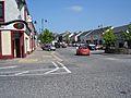
- Crossmaglen
- Markethill
- Mullavilly/Laurelvale
- Poyntzpass (partly in County Down)
Small Villages or Hamlets
Many smaller places exist, such as Camlough, Cullyhanna, and Newtownhamilton.
County Divisions

County Armagh is divided into areas called Baronies. These are old divisions that are no longer used for administration. Some of them are:
- Armagh
- Fews Lower
- Fews Upper
- Oneilland East
- Oneilland West
- Orior Lower
- Orior Upper
- Tiranny
The county also has many Parishes and Townlands.
Getting Around County Armagh
_-_geograph.org.uk_-_195736.jpg)

Two main highways cross County Armagh. The M1 motorway connects Belfast to Dungannon in the north. The A1/N1 road runs from Belfast to Dublin in the southeast. Other important roads include the A3 and A29.
County Armagh once had a large railway system. It connected to places like Armagh City and Markethill. Today, only a few stations are still served by trains. These include Newry (Bessbrook), Portadown, and Lurgan.
There are plans to reopen the railway line from Portadown railway station to Armagh railway station. This would help people travel more easily.
Ulsterbus provides most of the public transport in the county. They offer frequent bus services from many towns to Belfast. The Northern Ireland Railways / Iarnród Éireann's Enterprise train service connects to Dublin and Belfast daily.
Waterways
The Ulster Canal and the Newry Canal run through County Armagh. These canals are not fully open for boats right now.
Sports in County Armagh
In football, Glenavon is a team from the county that plays in the top division, the NIFL Premiership. Other teams like Portadown and Loughgall play in lower divisions.
The Armagh County Board organizes Gaelic games in the county. These games include Gaelic football and hurling.
Famous People from County Armagh
Many notable people have connections to County Armagh:
- Frank Aiken (1898–1983) – An Irish Republican and important Irish government minister.
- Saint Benignus of Armagh (died 467) – The first leader of the Cathedral School of Armagh.
- Brian Boru (941–1014) – A famous High King of Ireland, buried in Armagh City.
- Sir Robert Hart (1835–1911) – A key figure in China's customs service.
- Tommy Makem (1932–2007) – A well-known singer and musician, called "The Bard of Armagh."
- Seamus Mallon (1936–2020) – The first deputy First Minister of Northern Ireland.
- Colin Morgan (1986– ) – A famous actor.
- Paul Muldoon (1951– ) – A celebrated poet who won the Pulitzer Prize for Poetry.
- Tomás Ó Fiaich (1923–1990) – A Catholic Archbishop of Armagh.
- Sir William Olpherts (1822–1902) – A soldier who received the Victoria Cross.
- Ian Paisley (1926–2014) – A clergyman and politician, who became the second First Minister of Northern Ireland.
- Saint Patrick (fifth century) – The first Bishop of Armagh.
- George William Russell 'Æ' (1867–1919) – An author, critic, and painter.
- Colin Turkington (1982) – A professional racing driver.
- James Ussher (1581–1656) – A Church of Ireland Archbishop of Armagh.
- Richard Wellesley, 1st Marquess Wellesley (1760–1842) – A former Lord Lieutenant of Ireland.
- Andrew Nesbitt (1960) – A professional rally driver.
Cool Places to Visit
County Armagh has many interesting places to explore:
- Armagh Observatory and Armagh Planetarium – A place for studying stars and space.
- Armagh Public Library – Has old books from the 17th and 18th centuries.
- Navan Fort – An ancient site that was once home to Ulster's rulers. It has a modern visitor center.
- Saint Patrick's Church of Ireland Cathedral – Founded in 445, it holds the grave of Brian Boru.
- Saint Patrick's Roman Catholic Cathedral – Started in 1838, it stands on a hill and is a major landmark.
- Gosford Castle – A 19th-century castle that looks like a medieval one, with large grounds.
- Slieve Gullion – An extinct volcano with a lake in its crater. It offers views of nine counties.
Images for kids
-
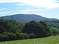
View of Slieve Gullion
-
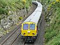
The Enterprise near Newry
-
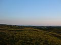
South Armagh Countryside
-
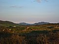
Forkhill Mountain
-
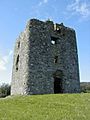
Moyry Castle
-
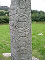
Killnasaggart Stone, 700 A.D.
-
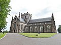
St. Patrick's Anglican Cathedral, est. 445
-
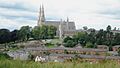
Armagh City
-
The small town of Markethill
-
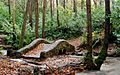
Clare Glen Forest, Tandragee
-
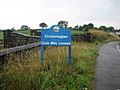
Approach to Crossmaglen
-
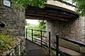
The Knock Bridge near Portadown on the Newry Canal
-
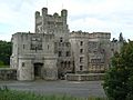
Gosford Castle, outside of Markethill


_-_geograph.org.uk_-_1590572.jpg)


See also
 In Spanish: Condado de Armagh para niños
