
Ulster Canal facts for kids
Quick facts for kids Ulster Canal |
|
|---|---|

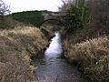
The remains of the Ulster Canal at Tyholland
|
|
| Specifications | |
| Length | 74 km (46 miles) |
| Locks | 26 |
| Status | abandoned |
| History | |
| Date completed | 1842 |
| Date closed | 1931 |
| Geography | |
| Start point | Charlemont, Lough Neagh |
| End point | Wattle Bridge, Lough Erne |
The Ulster Canal is an old waterway that runs through parts of Northern Ireland and the Republic of Ireland. It goes through County Armagh, County Tyrone, County Fermanagh, and County Monaghan.
In the early 1800s, people wanted to connect the areas around Lough Neagh with Lough Erne and the River Shannon. This idea was popular with landowners and business people. The Ulster Canal was built between 1825 and 1842. It was 74 km (46 mi) long and had 26 locks.
The canal started at Charlemont on the River Blackwater. It ended at Wattle Bridge on the River Finn, near Upper Lough Erne. However, the canal had problems. Its locks were too narrow for most boats used on other Irish waterways. It also didn't have enough water. Because of these issues, it was not successful for trade. The canal officially closed in 1931.
Today, Waterways Ireland is working to rebuild parts of the canal. Work started at the southern end in 2015.
Contents
Building the Ulster Canal: A Look Back
People first thought about building a canal in this area in 1778. The idea was to connect Ballyshannon to Lower Lough Erne. This was part of a bigger plan to create a waterway across Ireland, from Belfast to Limerick. This new canal would compete with other canals like the Grand Canal.
In 1783, the government gave money for the project. A part of the canal was built between Ballyshannon and Belleek. But in 1794, the money ran out, and the project stopped.
Early Plans and Problems
In 1814, there was a lot of unemployment in the area. Building a canal was seen as a way to create jobs. John Killaly, an engineer, surveyed a route in 1815. He estimated it would cost £233,000. His plan included 22 locks and a branch to Armagh.
However, Killaly made a big mistake. He planned the locks to be 76 by 14 feet (23.2 by 4.3 m). Boats on Lough Neagh and other nearby canals were wider, about 14.8 feet (4.5 m). This meant those boats could not use the new canal.
Even with strong local support, nothing happened for a while. The owners of the Lagan Canal wanted the new canal to increase their own trade. Finally, in 1825, a private company got permission to build the canal. A new survey suggested it would only need eighteen locks and cost £160,050.
Building Challenges and Costs
The company needed to borrow money. They got a loan of £120,000 after some delays. Construction began in 1832 with new contractors. But then, Thomas Telford, another engineer, found serious problems with the design. He decided more locks were needed, bringing the total to 26.
The contractors couldn't agree on new costs and left the project. John Killaly died in 1832. The locks were built only 12 feet (3.7 m) wide. This made them too narrow for most boats, meaning goods had to be moved to smaller boats at each end.
William Cubitt took over after Telford died in 1834. The canal was finally finished in 1841. It had 19 locks going down to Lough Neagh and seven going down to Lough Erne. Water came from Quig Lough reservoir. The very last lock at Wattle Bridge was the narrowest in Ireland, at just 11.7 feet (3.6 m) wide. The whole project cost over £230,000.
Why the Canal Failed
The Ulster Canal never had much trade. There wasn't enough water, and boats had to be unloaded and reloaded into smaller boats at each end. Also, it didn't connect to the River Shannon, which limited its use.
The company couldn't repay its loan. In 1851, the Board of Public Works took control. They leased it to William Dargan, who had built most of it. But by 1861, the canal was falling apart. Sir John Macneill, a railway engineer, even joked that it would be better to drain it and let cows graze there.
Attempts to Save the Canal
In 1865, the government took control again. They closed the canal and spent £22,000 on repairs over eight years. They tried to fix the water supply, but it still wasn't enough when the canal reopened in 1873. Maintenance cost much more than the money it made.
Most of the traffic was only at the Lough Erne end. The middle part was often too dry to use. In 1880, a new company tried to use smaller boats, and trade improved a little. The government vaguely promised help if a company took over the canal.
After many talks, the Lagan Navigation Company agreed to take over the Ulster Canal in 1888.
The Canal's Final Years
The Lagan Canal company was stuck with the Ulster Canal forever. They spent huge amounts of money trying to keep it open, much more than it earned. The profits from their other canals were used up trying to maintain the Ulster Canal. The company never fully recovered.
The last boat used the canal in 1929. The part of the canal in Northern Ireland was officially abandoned in 1931. This meant the Lagan Navigation Company was no longer responsible for its upkeep there.
However, the part of the canal in the Republic of Ireland was not abandoned. In the 1940s, Monaghan County Council tried to get money for unpaid taxes on the canal. The Lagan Navigation Company offered to give the canal to the Council, but the Council refused. They knew they couldn't afford to maintain the bridges and other parts.
The Lagan Navigation Co. was dissolved in 1954. This left the canal in Monaghan without an owner. It then became the property of the Minister for Finance. Later, some sections were taken over by local councils.
The Canal's Path

The canal generally runs in a straight line from south-west to north-east. It starts at Wattle Bridge on the River Finn and ends at Charlemont, where it joins the River Blackwater.
There were two locks near the River Finn and two more past Clones. Three locks were near Smithborough, where the highest point of the canal was reached. This highest section was less than 6 miles (10 km) long. It got its water from Quig Lough reservoir.
Two locks lowered the canal's level before Monaghan. There was a group of seven locks shortly after Monaghan. The border with Northern Ireland crosses the canal below these locks. There were also two separate locks near Middletown.
Fitting the canal through a gorge west of Benburb was very difficult. Six more locks were needed in this tricky area. There was another lock above Blackwatertown and the final lock below Charlemont, before the canal met the River Blackwater.
The highest point of the canal was 213 feet (65 m) above sea level. The original locks were built for boats that were 62 by 11 feet (18.9 by 3.4 m). In 2002, 56 bridges still crossed the canal.
Bringing the Canal Back to Life
In 1998, a study looked into reopening the canal. It found no major engineering problems. However, issues like lock size and water supply would need to be fixed. All old locks would need to be made much wider, at least 5 metres (16 ft), for modern boats.
The report said a restored canal would bring many financial benefits to the local area. But it also warned that if the original problems weren't solved, there would be little point in reopening it.

In 2004, Waterways Ireland announced that a reopened canal would greatly help the areas it passed through. It would connect to the already restored Shannon–Erne Waterway. Instead of just fixing the old canal, the plan was to build a modern waterway along the historic route.
In 2007, the governments announced plans to restore the part of the canal linking Clones to Upper Lough Erne. This project was estimated to cost €35 million.
Current Restoration Efforts
In February 2015, the Irish government approved the restoration of the canal between Castle Saunderson and the Erne basin. This funding came from Waterways Ireland. The project officially started in April 2015.
The first part of the work involved extending the Erne Navigation to Castle Saunderson. About 3 kilometres (1.9 mi) of this 5 kilometres (3.1 mi) section would be a new path, different from the original canal. A new Derrykerrib Bridge was also planned to allow bigger boats to pass.
There were some delays due to poor ground, flooding, and the need to keep roads open for local people. The new bridge and channel were expected to be finished by April 2018. By September 2019, the first phase of the Ulster Canal restoration was almost complete.
Images for kids
-
The remains of the Ulster Canal at Tyholland
-
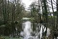
The canal at Clones Road, Monaghan
-
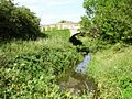
Ulster Canal at Tyholland.
See also
 In Spanish: Canal del Ulster para niños
