
River Erne facts for kids
Quick facts for kids River Erne |
|
|---|---|

The River Erne in Ballyshannon
|
|
| Native name | An Éirne |
| Country | Republic of Ireland, Northern Ireland |
| Physical characteristics | |
| Main source | Slieve Glah, County Cavan, Ireland ~255 m (837 ft) |
| River mouth | Atlantic Ocean at Ballyshannon, County Donegal |
| Length | ~129 km (80 mi) |
| Basin features | |
| Basin size | 4,372 km2 (1,688 sq mi) |
| Tributaries |
|
The River Erne is a very important river in the northwest of Ireland. It's the second-longest river in a region called Ulster. The Erne flows through both Northern Ireland and the Republic of Ireland. It even forms part of the border between them!
Contents
The Journey of the River Erne
The River Erne starts its journey on the eastern side of Slieve Glah mountain. This is in County Cavan, in the Republic of Ireland. From there, it flows for about 129 kilometers (80 miles).
Lakes Along the Way
The river passes through several large lakes. These include Lough Gowna, Lough Oughter, and both Upper and Lower Lough Erne. These lakes are mostly in County Fermanagh, Northern Ireland. It can be tricky to see where the river ends and the lakes begin. This is because the Erne winds through many connected lakes among the drumlin hills.
Where the Erne Ends
Finally, the River Erne reaches the sea at Ballyshannon. This town is in County Donegal, back in the Republic of Ireland. The town of Enniskillen is special because it sits on an island right in the middle of the river. It's located between Upper and Lower Lough Erne. The Erne is also connected to the River Shannon by the Shannon–Erne Waterway.
River Size and Flow
The total area that collects water for the River Erne is about 4,372 square kilometers. On average, the river flows at a speed of 101.7 cubic meters per second. That's a lot of water moving every second!
What's in a Name?
The River Erne gets its name from an old mythical princess. Her name was Éirne.
Fishing in the Erne
The River Erne is a popular spot for fly fishing. People come here to catch trout and salmon. There are many places along the river and its smaller streams where you can fish.
Changes Over Time
Years ago, power stations were built on the river at Cliff and Ballyshannon. This changed the river and affected the salmon. Now, fewer salmon swim up the river. In the 1960s, a fish called roach appeared, which might have caused the number of trout to go down. There were also problems with Water pollution in the 1970s.
A Comeback for Trout
Luckily, since 1987, pollution has been controlled. The roach population has also decreased. This means the trout have returned, and fishing for them is good again! You can find great trout fishing on the Erne and its smaller rivers.
_Company%27s_illustrated_guide_to_the_sporting_and_touring_grounds_of_the_north_of_Ireland_(1908)_(14777237441).jpg)
Fun on the Water
The Erne waterway is perfect for pleasure boating. You can rent boats in many places like Belturbet, Enniskillen, and Killadeas. People enjoy holidays on houseboats here.
Water Sports and Safety
Besides boating, sections of the river are used for water skiing, jet skiing, and even scuba diving. You can also go fishing from the river banks or by trolling from a boat. The Northern Ireland Tourist Board warns boaters that Upper Lough Erne has many small islands, so you need to be careful when navigating. Also, waves on Lower Lough Erne can get very big, almost like the open sea!
Ancient Places to Explore
The Erne waterway is home to many old ruins. These include both Christian and Pagan sites. You can find them in places like Crom Estate, Gad Island, Devenish Island, and White Island. Many of these historical spots can only be reached by boat.
Visiting Historical Sites
Devenish Island has a special center that tells you about its history. Visitors often rent boats and use maps to find these ancient places. It's like a treasure hunt for history!
The Erne in Music
The River Erne is so famous that it's mentioned in songs!
Popular Ballads
Buachaill Ón Éirne is an Irish song about a young boy from the Erne area. Famous groups like Clannad and The Corrs have recorded it. Another traditional song, An Mhaighdeán Mhara, also mentions the Erne. Singers like Mairéad Ní Mhaonaigh and Moya Brennan have performed it.
Old Railway Lines
In the past, you could travel by train to many places along the River Erne. The Great Northern Railway (Ireland) and the Sligo, Leitrim and Northern Counties Railway used to serve this area.

Images for kids
-
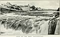
This picture from 1908 shows Ballyshannon before the River Erne was changed by the power stations.
-

This old bridge near Belturbet railway station is a reminder of the Great Northern Railway (Ireland) that once crossed the river.
See also
 In Spanish: Río Erne para niños
