
Lough Erne facts for kids
Quick facts for kids Lough Erne |
|
|---|---|
 |
|

Lough Erne
Location in Northern Ireland
|
|
 |
|
| Location | County Fermanagh, Northern Ireland |
| Coordinates | 54°28′N 7°49′W / 54.467°N 7.817°W |
| Native name | Loch Éirne Error {{native name checker}}: parameter value is malformed (help) |
| Primary inflows | River Erne |
| Primary outflows | River Erne |
| Catchment area | 1,680 sq mi (4,350 km2) |
| Basin countries | Northern Ireland and Republic of Ireland |
| Max. length | Lower: ~26 mi (42 km) Upper: ~12 mi (19 km) |
| Surface area | Lower: ~42.3 sq mi (110 km2) Upper: ~13.3 sq mi (34 km2) |
| Average depth | Lower: ~39 ft (12 m) Upper: ~7.5 ft (2.3 m) |
| Max. depth | 213.25 ft (65.00 m) |
| Islands | 150+ |
| Settlements | Enniskillen, Belturbet, Belleek, Pettigo, Kesh, Trory, Ballycassidy, Killadeas, Derrylin |
| Official name: Upper Lough Erne | |
| Designated: | 4 March 1997 |
| Reference #: | 896 |
Lough Erne (pronounced LOKH AIRN) is the name for two connected lakes in County Fermanagh, Northern Ireland. It's the second largest lake system in Northern Ireland and the fourth largest in all of Ireland. These lakes are actually wider parts of the River Erne, which flows towards the Atlantic Ocean.
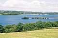
The smaller lake to the south is called the Upper Lough. It is higher up the river. The larger lake to the north is called the Lower Lough or Broad Lough. The town of Enniskillen sits on the short river section between the two lakes. Lough Erne has over 150 islands, plus many hidden coves and inlets.
The Lower Lough is about 26 miles (42 km) long. When it's windy, sailing here can be tricky because the waves can get very big. The Upper Lough is shallower and spreads out for about 12 miles (19 km) southeast of Enniskillen. It's like a maze of islands. The River Erne itself is 80 miles (129 km) long. It drains an area of about 1,680 square miles (4,350 km2).
Contents
What's in a Name? Myths and Legends
Lough Erne (Loch Éirne in Irish) might be named after an ancient group of people called the Érainn. Or it could be named after a goddess from whom the Érainn got their name. Some experts think the Érainn were named after a goddess called Érann. This would mean Loch Éirne probably means "lake of (the goddess) Érann."
Scholars have linked these names to Ériu, the goddess after whom Ireland is named. Some believe Érann and Ériu mean "she who travels regularly." This could refer to the sun goddess, as the sun is a great traveler in the sky. Another idea is that Ériu was a mother goddess whose name means "fat, rich, fertile," suggesting she brought good harvests.
Tales of How the Lake Was Formed
In Irish mythology and folklore, there are three main stories about how Lough Erne came to be.
- One story says the lake is named after a mythical woman named Erne. She was a lady-in-waiting to Queen Medb at Rathcroghan. Erne and her friends ran away from Rathcroghan when a scary giant appeared. They fled north and drowned in a river or lake. Their bodies then dissolved to form Lough Erne. This idea of a goddess drowning often means her power goes into the water, which then gives life to the land.
- Another tale says the lake formed when a magical spring well overflowed. This is similar to the story of Lough Neagh.
- The third story says that during a battle, the lake burst from the ground and drowned a group of people called the Érainn.
Lough Erne is also mentioned in an old Irish tale called Cath Maige Tuired ("the Battle of Moytura"). It is listed as one of the twelve most important lakes in Ireland. In the past, the lake was also called Loch Saimer. Folklore says that Partholón killed his wife's favorite dog, Saimer, there. The lake was then named after the dog.
The Golden Apples of Lough Erne
Lough Erne is the setting for a folk tale called "The Story of Conn-eda" or "The Golden Apples of Lough Erne." This story is found in Fairy and Folk Tales of the Irish Peasantry (1888). In the tale, Conn-eda goes on a journey to find three golden apples, a black horse, and a magical dog. These items are hidden in a city beneath Lough Erne. The city is ruled by a king of the Fir Bolg.
A Look Back in Time: History of Lough Erne
The Menapii were an ancient Celtic tribe. They are the only Celtic tribe specifically named on a map of Ireland from AD 150. They first settled on the Leinster coast around 216 BC. Later, they moved to the area around Lough Erne. They became known as the Fir Manach, which gave their name to Fermanagh and Monaghan counties.
The Annals of Ulster are important historical records. They were written in the late 15th century on Belle Isle, an island in Upper Lough Erne.
Lough Erne During World War II
During the Second World War, RAF Castle Archdale was based on Lough Erne. This airbase was very important for the Battle of the Atlantic. It helped in the fight against German U-boats (submarines). There was a secret agreement with the Irish Government. This allowed flying boats from the base to fly directly over neutral Ireland to the Atlantic. This saved two hours of travel time compared to flying around Ireland. This shows one of the ways Ireland helped the Allies while staying neutral.
In November 2012, the Lough Erne Resort hosted the 39th G8 summit. This was a meeting of leaders from the world's major industrial countries.
Exploring the Geography of Lough Erne
Islands of the Lough
Lough Erne has many small islands and peninsulas. Many of these areas are called "islands" because the shoreline is very twisty. Also, many were true islands before two big drainage projects in the 1880s and 1950s. These projects lowered the water level by about 5 feet (1.5 meters).
In 1846, a report said that people believed there were as many islands as days in the year. However, a more careful count estimated about 90 islands in the Upper Lake and 109 in the Lower Lake.
The largest islands are Inishmore in Upper Lough Erne and Galloon Island in Lower Lough Erne. The next largest is Boa Island in Lower Lough Erne. Many of the other large islands are made up of a single "townland," which is a small land division.
Some islands in the lower lake include Boa Island, Devenish Island, Ely Island, Goat Island, Horse Island, Inish More or Davy's Island, Inis Rath, and White Island.
Islands in the upper lake include Bleanish Island, Crehan Island, Dernish Island, Inishcorkish, Inishcrevan, Inishfendra, Inishleague, Inishlught, Inishrath, Inishturk, and Trannish. Some of these islands are privately owned and sometimes go up for sale.
The lake islands are a key place in Ireland for the rare garden warbler bird.
How Lough Erne is Managed
Waterways Ireland is an organization that works across the border between Northern Ireland and the Republic of Ireland. It was set up under the Belfast Agreement in 1999. This group is in charge of helping boats navigate the Erne System and other waterways in Ireland.
The Department for Infrastructure Rivers owns the lakebed and shoreline. It also manages the water levels. These levels are set by the Erne Drainage and Development Act (1950). Water levels are controlled together with the Electricity Supply Board (ESB) in the Republic of Ireland. This is because the River Erne is used to create hydroelectric power.
The agreement from 1950 says that water levels in the Upper Lough should be kept between 150 feet and 154 feet (April to September) or 155 feet (October to March). In the Lower Lough, levels should be between 147 feet and 152 feet. These levels are measured from a specific point called the Irish grid datum at Poolbeg Lighthouse.
Water levels in both Lough Erne lakes are controlled by structures at Portora in Enniskillen. They are also controlled by the hydroelectric power station at Cliff, between Belleek and Ballyshannon. During the summer, the goal is to keep the water level at Portora at or above 150 feet. This helps boats use the navigation lock without problems during the busy tourist season.
It's hard to quickly lower water levels in the Upper Lough because the channel between the lakes is narrow. This means that the Rivers Agency must try to predict when a lot of water will flow into the loughs. They lower the loughs beforehand to make sure there's space for floodwater. In November 2009, the Erne system had a very big flood. The water levels were the highest recorded since the changes made in the 1950s.
The Erne Rivers Trust is a non-profit group. They work to keep the water clean in the Lough Erne area for all the plants and animals.
Fun on Lough Erne: Sports and Tourism
The Lough Erne area is very popular for angling (fishing) and watersports. Some of the most popular activities include waterskiing, rowing, and wakeboarding. The water near the Broadmeadow in Enniskillen has hosted parts of the World Waterski Championships every year since 2005. In 2007, a pro-wakeboard competition called 'Wakejam' was held there. Canoeing is also a popular sport on the Erne.
The Lough Erne Yacht Club is located in Gublusk Bay. The Lough Erne Regatta is Ireland’s oldest sailing race event, dating back to before 1820. The RNLI (Royal National Lifeboat Institution) has an inland lifeboat and rescue boat based at Gublusk. There is another station at Carrybridge on the Upper lake.
The Lough Erne Golf & Hotel Resort opened in October 2007. It is on a 600-acre piece of land between Castle Hume Lough and Lower Lough Erne. The resort hosted the Lough Erne Challenge golf tournaments in 2009 and 2010.
Getting Around: Transport
A canal called the Shannon–Erne Waterway connects the upper part of the River Shannon to the River Erne. This allows boats to travel from the Shannon estuary in southwest Ireland, through the middle of the country, and across to the northwest.
Plans are being made to restore the section of the Ulster Canal that connects Lough Erne to Clones. This will allow boats to use this part of the canal again.
Images for kids
-
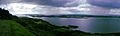
Lower Lough Erne.
-
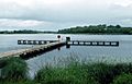
Upper Lough Erne.
-
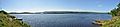
Upper Lough Erne Panorama.
-
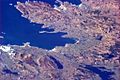
Lough Erne from the International Space Station (lower right).
-
Lower Lough Erne


See also
 In Spanish: Lago Erne para niños
