
Lough Oughter facts for kids
Quick facts for kids Lough OughterLoch Uachtair |
|
|---|---|

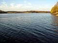
View from Killykeen
|
|

Location in island of Ireland
|
|
| Location | County Cavan |
| Coordinates | 54°01′01″N 7°23′18″W / 54.01694°N 7.38833°W |
| Type | Eutrophic Glacial lake between drumlins. |
| Primary inflows | from various springs and streams |
| Primary outflows | River Erne Atlantic Ocean, Ballyshannon |
| Basin countries | Ireland |
| Designation | Ornithological, botanical, zoological interest |
| Max. length | 12 km (7.5 mi) |
| Max. width | 10 km (6.2 mi) |
| Surface area | 8,931 ha (22,070 acres) |
| Frozen | Winter of 2010/2011 |
| Designated: | 7 June 1996 |
| Reference #: | 853 |
Lough Oughter (Irish: Loch Uachtair) is a big lake system in County Cavan, Ireland. It covers more than 8,900 hectares (22,000 acres) of land and water. This group of lakes is part of the River Erne and forms the southern end of the larger Lough Erne complex. The lakes are found near towns like Belturbet to the north, Cavan to the east, Crossdoney to the south, and Killeshandra to the west.
Contents
Geography and Nature
A Unique Landscape
Lough Oughter is special because it's a "flooded drumlin landscape." Drumlins are small, oval-shaped hills formed by glaciers. Imagine a bunch of these hills, and then the spaces between them filled with water – that's Lough Oughter! This mix of land and water is very rare in Ireland.
Amazing Wildlife
The area is home to many different plants and animals. You can find lots of wetland plants here that are not common anywhere else.
- Birds: Many birds love Lough Oughter. About 3% of all the whooper swans in Europe spend their winters here. The lake also has the biggest group of Great Crested Grebes in the Republic of Ireland. These birds almost disappeared in the 1800s, so it's great they are thriving here.
Protected Areas
Lough Oughter is so important for nature that it has several special protections:
- Ramsar Site: It's listed under the Ramsar Convention, which means it's a wetland of international importance. This helps protect its natural environment.
- Natura 2000: The Lough Oughter area, along with Killykeen Forest Park, is part of the Natura 2000 network. This means it's a Special Area for Conservation (SAC) and a Special Protection Area (SPA) under European Union laws. These laws help protect important habitats and species.
- UNESCO Geopark: Lough Oughter is also part of the Marble Arch Caves Global Geopark, which is recognized by UNESCO for its unique geology and natural heritage.
Protecting the Lake
Even though Lough Oughter is protected, it faces some challenges.
- Water Pollution: Things like fertilizer and animal waste from farms, and sewage from towns, can run into the lake. This adds too many nutrients to the water, which can harm the plants and animals.
- Forestry: Planting too many trees in some areas has also caused some wetland habitats to shrink. This can reduce feeding grounds for wintering birds.
Fun and Tourism

Lough Oughter is a great place for ecotourism, which means enjoying nature in a way that protects it.
- Killykeen Forest Park: This park is managed by Coillte and covers 240 hectares (590 acres). It's a beautiful woodland right next to the Lough Oughter lakes, perfect for walks and enjoying the outdoors.
History of the Area

The Lough Oughter area has a rich history with old settlements and castles.
Trinity Island
Trinity Island, located on Lough Oughter, was once home to a group of monks. A friary, which is a type of monastery, was built on the island in the 12th or 13th century.
Clogh Oughter Castle
Cloughoughter Castle is a famous landmark in the area. It was built in the 13th century by the Anglo Normans.
- Location: This circular castle stands on a tiny island in Lough Oughter. It's about 15.5 metres (51 ft) wide and almost 18 metres (59 ft) tall. The closest land is about 130 metres (430 ft) away.
- History: In the 1600s, during the time of the Confederate Wars (a period of conflict in Ireland), the castle was fought over many times. It was one of the last castles to remain standing during these wars.
- Prison: Before the wars, Clogh Oughter Castle was used as a prison. William Bedell, an important church leader, was held here.
- Owen Roe O'Neill: A famous Irish general named Owen Roe O'Neill is believed to have died at the castle in 1649. His body was secretly taken to Trinity Island for burial.
- After the Wars: The castle was captured in 1653, and its walls were damaged by cannon fire. It has been empty ever since.
Water Levels
In the late 1800s, the water levels on Lough Oughter were lowered. This was done to help prevent flooding on nearby farmland. However, in 2008, there was a plan to raise the water levels again. This would help boats get into the lough from the River Erne, making it easier for tourism.
Images for kids
-
View from Killykeen
