
River Blackwater (Northern Ireland) facts for kids
Quick facts for kids River Blackwater |
|
|---|---|

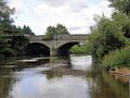
Charlemont Bridge over the River Blackwater, which connects Charlemont, County Armagh, to The Moy, County Tyrone.
|
|
| Native name | Cluain-Dabhail / An Abhainn Mhór |
| Country | Ireland |
| Physical characteristics | |
| Main source | north of Augher, County Tyrone 59 metres (194 ft) |
| River mouth | Lough Neagh |
| Length | 91.3 kilometres (56.7 mi) |
| Basin features | |
| Basin size | 1,507 square kilometres (582 sq mi) |
| Tributaries |
|
The River Blackwater, also called the Ulster Blackwater, is a river mostly found in County Armagh and County Tyrone, Northern Ireland. It also forms a small part of the border between the United Kingdom and the Republic of Ireland. The river starts north of Fivemiletown, County Tyrone. It acts as a natural boundary, separating County Armagh from County Tyrone, and also County Tyrone from County Monaghan.
Contents
River's Path
The River Blackwater flows into Lough Neagh west of Derrywarragh Island. You can travel by boat on the river from Maghery all the way to Blackwatertown. A small waterway called the Maghery Canal joins the Blackwater near Derrywarragh Island. Close by, there's a small area with a boat ramp where the Maghery ferry used to operate.
About 4 kilometers (2.5 miles) from the old ferry spot, you'll find the river entrance, just past Bond’s Bridge. On the east side of the river, there's a large country house estate called The Argory. This beautiful place was given to the National Trust by the MacGeough-Bond family. The Callan River joins the Blackwater about 1.6 kilometers (1 mile) upstream. Further along, you'll see the entrance to the first lock of the Ulster Canal on the east bank. Just a bit further upstream, Charlemont Bridge connects the village of Charlemont on the east bank with The Moy on the west.
The Blackwater river is 91.3 kilometers (56.75 miles) long. If you follow its path through Lough Neagh (which is 30 kilometers or 19 miles long) and then along the Lower Bann to the sea (which is 64.4 kilometers or 40 miles long), the total journey is 186.3 kilometers (115.75 miles). This makes the Blackwater–Neagh–Bann system the longest natural river flow in Ulster. It is even longer than the Munster Blackwater river.
Old Names of the River
Long ago, the River Blackwater was known in the Irish language as Cluain-Dabhail. This name means "meadow of Dabhal." This was later changed to Clanaul, which was the old name for the area of Eglish. It was also called Glenaul, which was used for a local election area in Armagh.
The river was also known as An Abhainn Mhór, which means "The Great River." There's a place in Blackwatertown, where the river flows, that is called Avonmore. This name reflects the old name of the river nearby.
Fishing in the River
In the lower parts of the river, especially upstream from Blackwatertown Bridge, you can find many different types of fish. There is also a good spot for game fishing (like salmon) downstream of the island. After some work was done on the river in the late 1980s, the number of game fish is now growing again.

River's History
In the late 1700s and early 1800s, people in Ireland started building canals to connect different waterways. By 1814, there was a plan to link Lough Neagh to Lough Erne, and then Lough Erne to the River Shannon. This would create a large network for boats to travel.
Even though money was tight, the plan for the canal was started again in 1822. The Ulster Canal was finally finished in 1841. This canal joined the Blackwater river below the first lock at Charlemont. Boats then used the river to reach Lough Neagh. However, not many boats used the canal, so it wasn't very successful. The Board of Works took it over in 1851.
Around the same time, the Office of Public Works (also known as 'the Board of Works') started a big project in 1842. Their goal was to improve drainage, navigation, and power for mills around the Lough Neagh area. They planned to make the Lower Bann easier to travel on from Lough Neagh to the sea. This involved removing a large rocky area at Portna. This work lowered the water level of Lough Neagh by about 6 feet (1.8 meters).
This change had a big effect on the River Blackwater. A lot of work was needed to keep it deep enough for boats. The Maghery Cut, which allowed boats to enter Lough Neagh, had to be made deeper and wider. The river channel itself was also dug out to keep a good depth for boats. The last locks on the Coalisland Canal and the Ulster Canal had to be rebuilt with lower sills and deeper gates to match the new, lower river level. The same was done for the last lock on the Newry Canal.
The total cost of this big project was estimated at £183,775. The work on the Blackwater river cost more than any other river flowing into Lough Neagh. The first 5 miles (8 kilometers) of the river above the lough were already wide. However, a lot of work was needed between there and Blackwatertown to remove sharp bends and shallow areas. New parts of the river channel were dug, making them about 80 to 90 feet (24 to 27 meters) wide. They were also made deep enough to have 6 feet (1.8 meters) of water even when Lough Neagh was at its lowest level in summer. The dirt dug out was used to fill in the old river channels, so not much land was lost.
To protect the low-lying land around the river from floods, banks were built along the channel. These banks had special gates that would open by themselves to let smaller rivers flow through when the water levels were right. However, after some banks were finished, local landowners asked for the work to stop. They felt that the lower level of Lough Neagh and the work already done were enough to protect their land. So, some of the protection work was put on hold.
The original plan was to build banks along the Tall River and the Callan River. These two rivers joined south of Clonmain and flowed into the Blackwater below Charlemont bridge. This part of the project was changed. A new, straight cut was made from the Tall River, crossing Sir William Verner's bog. This new cut rejoined the Blackwater just above Verner's Bridge, about 5 miles (8 kilometers) below where the rivers originally met. This was helpful because during floods, the water level in the Blackwater was 4 to 5 feet (1.2 to 1.5 meters) lower than further upstream. The channel below Verner's Bridge was also much wider, so it could handle the large amounts of water from the two smaller rivers better.
The entire project took eleven years to finish, and it cost £50,000 more than planned. The government helped pay for the extra costs. When the project started, there was supposed to be one group in charge of maintaining all the work. The idea was that the more profitable Lower Bann would help pay for the less profitable Blackwater and Upper Bann. However, by the time it was done, three separate groups were set up. The Upper Bann and the Blackwater were managed by the Upper Bann Navigation Trust. The counties south of Lough Neagh were expected to pay for their part of the work and contribute £800 each year to run the Trust, even though they had no income from it. The Lower Bann Navigation Trust and the Lough Neagh Drainage Trust were closed in 1929, and their duties went to the Ministry of Finance. But even with strong efforts from the counties, the government refused to close the Upper Bann Navigation Trust. It continued to be funded until 1954, when the Ministry of Commerce took over the waterways and effectively closed them down.
Images for kids
-
Charlemont Bridge over the River Blackwater.
See also
 In Spanish: Río Blackwater para niños
