Derrywarragh Island facts for kids

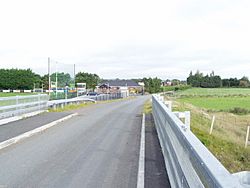
Looking towards Derrywarragh Island on the bridge connecting the island and Maghery
|
|
| Geography | |
|---|---|
| Location | Lough Neagh, County Armagh |
| Coordinates | 54°30′58″N 6°34′16″W / 54.516°N 6.571°W |
| Area | 0.6 km2 (0.23 sq mi) |
| Length | 1 km (0.6 mi) |
| Width | 0.6 km (0.37 mi) |
| Highest elevation | 12 m (39 ft) |
| Highest point | O'Connor's Stronghold |
| Administration | |
|
United Kingdom
|
|
Derrywarragh Island is a cool island located in Lough Neagh, Northern Ireland. It's made of something called boulder clay, which is a mix of clay, sand, and rocks left behind by glaciers. The island is connected by a bridge to a place called Maghery in County Armagh.
Derrywarragh Island is about 13 kilometers (8 miles) northwest of Portadown. Most of the island is covered in wet grassland. You can also find areas of wet woodland, marshes, and swamps. Many different kinds of birds visit the island regularly. Some birds stay for the winter, while others come to breed their young.
Contents
Discovering Derrywarragh Island's Past
Derrywarragh Island has an interesting history. It wasn't always an island! Long ago, boats traveling on the River Blackwater had trouble reaching Lough Neagh. The river mouth was often blocked by sand and floods.
How Derrywarragh Became an Island
In 1802, a big project began to solve the river's problems. Workers started digging a new, shorter channel. This channel went straight from the River Blackwater to the shore of Lough Neagh. This new path cut through a part of the Derrywarragh Peninsula.
The digging work was finished in 1803. This new channel, called "the Maghery Cut," helped boats avoid the sandy areas. Because of this cut, the peninsula became what we now know as Derrywarragh Island.
The Island's Bridge Connection
After the island was formed, a special floating bridge, called a pontoon bridge, was put in place. This bridge allowed people to get onto Derrywarragh Island. Later, a stronger, fixed bridge replaced the old one. This was important for a local resident who owned a business transporting livestock. Their heavy lorries needed a sturdy bridge to cross safely.
Exploring Places of Interest on the Island
Derrywarragh Island is home to an old and interesting structure.
The O'Connors Stronghold: A Historic Watchtower
On the north-east side of the island, you can find the remains of the O'Connors Stronghold. This was a fortified house built in the 1600s. Today, the remaining walls are about 18 by 14 feet (5.5 by 4.3 meters). There's also a tall brick chimney stack still standing, which is about 32 feet (9.8 meters) high.
Experts believe this stronghold was likely a "watchtower." Its job was to protect the entrance of the River Blackwater. Imagine someone standing there, keeping an eye out for anything unusual!
Sporting Life on Derrywarragh Island
Derrywarragh Island is also a place for sports and community activities.
Maghery Sean MacDermott's GAA Club
The island is the home ground for the Maghery Sean MacDermott's GAA club. GAA stands for the Gaelic Athletic Association. This club plays traditional Irish sports like Gaelic football and hurling. It's a big part of the local community's life and brings people together for games and events.
See also
 In Spanish: Isla Derrywarragh para niños
 | William Lucy |
 | Charles Hayes |
 | Cleveland Robinson |

