
Portadown facts for kids
Quick facts for kids Portadown
|
|
|---|---|
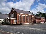
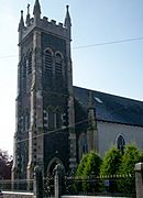
 St Mark's Church of Ireland in central Portadown |
|

|
|
| Population | 32,926 (2021 estimate) |
| Irish grid reference | J008537 |
| • Belfast | 24 mi (39 km) |
| • Dublin | 74 mi (119 km) |
| District |
|
| County | |
| Country | Northern Ireland |
| Sovereign state | United Kingdom |
| Post town | CRAIGAVON |
| Postcode district | BT62, BT63 |
| Dialling code | 028 |
| Police | Northern Ireland |
| Fire | Northern Ireland |
| Ambulance | Northern Ireland |
| EU Parliament | Northern Ireland |
| UK Parliament |
|
| NI Assembly |
|
Portadown is a town in County Armagh, Northern Ireland. Its name comes from the Irish Port an Dúnáin, which means "landing place of the little fort". The town is located on the River Bann in the northern part of the county, about 24 miles (39 km) southwest of Belfast. It is part of the Armagh City, Banbridge and Craigavon Borough Council area. In 2021, about 32,000 people lived there. Portadown is sometimes seen as part of the "Craigavon Urban Area" along with Craigavon and Lurgan.
Portadown began in the early 1600s during the Plantation of Ulster. However, it really grew into a big town during the Victorian era when the railway arrived. It was even called the "hub of the North" because it was a major railway junction. Trains from Portadown could go to Belfast, Dublin, Armagh, and Derry. In the 1800s and 1900s, Portadown was also famous for making linen textiles.
The town has also been known for the Drumcree dispute. This was about yearly marches by the Protestant Orange Order through a Catholic part of the town. These events sometimes led to protests and violence. In the 1990s, this dispute became very serious, needing a huge security effort and bringing worldwide attention to Portadown.
Contents
- History of Portadown
- Geography of Portadown
- People of Portadown
- How Portadown is Governed
- Places of Worship
- Getting Around Portadown
- Portadown's Economy
- Famous Places in Portadown
- Notable People from Portadown
- Education in Portadown
- Healthcare in Portadown
- Sports in Portadown
- Media in Portadown
- See also
History of Portadown
Early Times and the Plantation of Ulster
The area around Portadown was first home to Irish Gaels. In the early 1600s, it was part of a district called Clancann, named after the McCanns clan. The town's name, Port a' Dúnáin, likely refers to a small fort belonging to the McCanns.
From 1594 to 1603, Irish clans fought against the English in the Nine Years' War. The Irish clans lost, and their land was taken by the Crown. In 1608, King James VI and I started the Plantation of Ulster. This was a plan to settle Protestant people from Britain in the area.
In 1610, the land of Portadown was given to William Powell. He later sold it to others, including Michael Obins. Obins built a large house for his family and homes for English settlers. This house was in the area of today's Woodside estate, and People's Park was once part of its grounds. In 1631, Obins was allowed to hold a "fair and market," which led to the first bridge being built over the River Bann.
Irish Rebellion of 1641
During the Irish Rebellion of 1641, Obins Castle was taken by Irish rebels. In November 1641, about 100 British settlers who had been captured were killed. They were forced off the Bann bridge, and those who tried to swim were shot. This event became known as the "Portadown massacre". It led to more violence later and was used to explain why the Cromwellian conquest of Ireland happened.
Growing Industries
In 1741, Anthony Obins helped develop the Newry Canal. Later, Michael Obins started a linen market in Portadown in 1762. This was the beginning of Portadown's main industry: linen.
Over time, the land changed hands. The Sparrow family and later the Duke of Manchester owned the estate. Their names can still be seen in street names like Montagu Street and Millicent Crescent.
The Blacker family, who were important in the area, also owned land nearby. Colonel William Blacker was a founder of the Orange Order. Because of this, and other events, Portadown became known as 'The Orange Citadel' and saw many conflicts between different groups over two centuries.
World War II in Portadown

During World War II, a large prisoner-of-war (POW) camp was built in Portadown. It was located where the Fitzroy Street and Brownstown Estates housing areas are now. This camp held mostly German POWs. There were also other smaller camps in the area.
In 2005, a public air-raid shelter from World War II was found near the river. It is one of the few remaining public air raid shelters in Northern Ireland.
The Troubles and Peace Walls
During the Troubles, Portadown experienced many shootings, bombings, and riots. Sadly, 45 people died in the town during this time. The conflict caused the town to become divided. The northwestern part became mostly Catholic/Irish nationalist, while the rest of the town became mostly Protestant/unionist. A "peace wall" was built along Corcrain Road to separate these areas.
The Troubles also made the Drumcree marching dispute worse. From 1995 to 2000, this dispute gained worldwide attention. It caused protests and violence across Northern Ireland and involved a huge police and army operation. The army even sealed off the Catholic part of Portadown with large barriers, making it look like a "war zone."
Every summer, during the "marching season," there are many Protestant/loyalist marches in the town. Loyalists put up many flags and build arches over some streets. These marches and displays near Catholic homes can still cause tension.
Since 1975, community leaders in Portadown have been part of the Ulster Project. This project helps teenagers from both main communities in Northern Ireland become friends. Each year, a group of teenagers travels to the United States to stay with American families.
Geography of Portadown


Portadown is in a flat part of Ireland, close to Lough Neagh. There are two small wetland areas nearby. The Ballybay River flows into the town and joins the River Bann.
The River Bann
Most of Portadown is built on the west side of the River Bann. The river helped the town become successful. The Newry Canal, built in 1740, connected Carlingford Lough to Lough Neagh. This made Portadown a busy place for water traffic between Newry and Belfast.
There are three bridges over the river in Portadown: two for roads (Bridge Street and Northway) and one for the railway. The 'Bann Bridge' on Bridge Street is the oldest. It was built before the river was even under it! The river's path was later changed to flow under the bridge.
Townlands of Portadown
Like other parts of Ireland, the Portadown area is divided into townlands. Their names often come from the Irish language. Portadown grew up along a road that was the border between two townlands: Tavanagh and Corcrain. Many roads and housing areas in Portadown are named after these old townlands.
Here are some of the townlands in Portadown:
- On the west side of the River Bann: Annagh, Ballyoran, Baltylum, Clounagh, Corcrain, Garvaghy, Mahon, Selshion, Tavanagh.
- On the east side of the River Bann: Ballyhannon, Bocombra, Edenderry, Kernan, Killycomain, Levaghery, Lisnisky, Seagoe Upper.
Portadown's Climate
Portadown has a temperate oceanic climate, similar to the rest of the UK and Ireland. This means it has mild temperatures all year round. Summers are not usually very hot, and winters are not very cold. Summer temperatures can reach over 20°C (68°F), but rarely go above 30°C (86°F). It also rains steadily throughout the year.
| Climate data for Portadown | |||||||||||||
|---|---|---|---|---|---|---|---|---|---|---|---|---|---|
| Month | Jan | Feb | Mar | Apr | May | Jun | Jul | Aug | Sep | Oct | Nov | Dec | Year |
| Mean daily maximum °C (°F) | 7.4 (45.3) |
8.1 (46.6) |
10.2 (50.4) |
12.6 (54.7) |
15.6 (60.1) |
18.0 (64.4) |
19.7 (67.5) |
19.3 (66.7) |
16.9 (62.4) |
13.4 (56.1) |
10.0 (50.0) |
7.7 (45.9) |
13.3 (55.9) |
| Mean daily minimum °C (°F) | 1.9 (35.4) |
1.6 (34.9) |
3.1 (37.6) |
4.3 (39.7) |
6.7 (44.1) |
9.6 (49.3) |
11.7 (53.1) |
11.4 (52.5) |
9.5 (49.1) |
6.8 (44.2) |
3.9 (39.0) |
2.1 (35.8) |
6.1 (43.0) |
| Average precipitation mm (inches) | 74.5 (2.93) |
54.0 (2.13) |
65.6 (2.58) |
57.6 (2.27) |
57.8 (2.28) |
58.4 (2.30) |
62.7 (2.47) |
76.3 (3.00) |
68.1 (2.68) |
85.5 (3.37) |
74.6 (2.94) |
77.1 (3.04) |
812.3 (31.98) |
| Average precipitation days (≥ Days of rainfall >= 1 mm) | 14.3 | 11.0 | 13.3 | 11.6 | 11.8 | 10.9 | 11.7 | 13.0 | 12.2 | 13.7 | 13.6 | 13.3 | 150.3 |
| Source: Met Office | |||||||||||||
People of Portadown
The Northern Ireland Statistics and Research Agency (NISRA) groups Portadown with Craigavon and Lurgan for census purposes. However, we can estimate Portadown's population by looking at its electoral wards.
On March 21, 2021, the population of these wards was 32,926.
- 17,063 people (51.8%) were Protestant or from a Protestant background.
- 12,205 people (37.0%) were Catholic or from a Catholic background.
- 3,658 people (11.2%) were from other religious backgrounds or no religious background.
Many immigrants live in Portadown, making up about 8% of the town's population. They come from places like Eastern Europe, Portugal, East Timor, China, and India.
How Portadown is Governed

Portadown is part of the Upper Bann area for elections to the Northern Ireland Assembly and the Parliament of the United Kingdom. This area has usually voted for unionist politicians.
Portadown used to have its own local government called Portadown Borough Council. But after changes in 1972, it became part of the larger Craigavon Borough Council. Now, after more local government changes, Portadown is part of the Armagh, Banbridge and Craigavon Borough Council. Councillors are chosen every four years.
Places of Worship
Portadown is split by the River Bann, which also forms the border between two church parishes: Drumcree (west of the Bann) and Seagoe (east of the Bann).
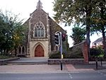
Protestant Churches
Many Protestant churches are in Portadown. Saint Mark's Church of Ireland was built in 1826. Before that, people went to churches in Drumcree or Seagoe. The current Seagoe Parish Church was built in 1814.
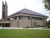
There are also two Presbyterian churches: First Portadown Presbyterian Church (1822) and Armagh Road Presbyterian Church (1859). Other churches include Baptist, Elim, Quaker, Free Presbyterian, Light of the World Ministries, Vineyard Church, and the Salvation Army.
-
Edenderry Methodist
-
Armagh Road Presbyterian
-
Seagoe Parish
-
Friends Meeting House


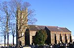
Catholic Churches
Saint John the Baptist's Church was built in 1783. A second Catholic church, Saint Patrick's, was built in 1835.
In the 1980s, the original Saint John's church was carefully taken apart and rebuilt at the Ulster Folk and Transport Museum in Cultra. A new Saint John's church was built nearby and finished in 1977.
-
Saint Patrick's Roman Catholic
-
Saint John's Roman Catholic


Other Churches
The Church of Jesus Christ of Latter-day Saints has a church on Brownstown Road. The Jehovah's Witnesses have a Kingdom Hall in Kernan.
Getting Around Portadown

Portadown was called the "Hub of the North" because of its good road, canal, and rail links. These links helped create jobs and boost trade. The Newry Canal, opened in 1742, connected Carlingford Lough to Lough Neagh, making Portadown a key trading spot. However, the canal was used less as railways grew, and it closed in 1936.
The Great Northern Railway made trade faster. Portadown's first railway station opened in 1842. From Portadown, railway lines went in four directions: to Belfast, Dungannon, Armagh, and Newry (on to Dublin). Today, only the Belfast–Dublin line remains. The current station opened in 1970.
National Cycle Route 9 connects Portadown with Belfast and Newry for cyclists.
Portadown's Economy
Portadown has had several important employers:
- Irwin's Bakery: Started in 1912, this bakery grew to sell its products across Great Britain and Ireland.
- Ulster Carpets Ltd: This company, founded in 1938, was a major employer, making woolen carpets.
- Henry Denny & Sons (NI) Ltd: A meat processing company.
Linen Manufacturing
For many years in the 1800s and 1900s, much of Portadown's industry was focused on making linen. In 1881, a directory listed 15 manufacturing businesses in Portadown, many of which were involved in the linen trade.
Famous Places in Portadown

Portadown Town Hall, built in 1890, is a Victorian building that has been updated. It now has a theatre and places for conferences.
The Millennium Court Arts Centre has two galleries where local artists can show their work.
Ardress House is a 17th-century farmhouse that was changed in Georgian times. Today, the National Trust owns it. You can visit it for guided tours and walks.
The Newry Canal Way is a path along the old canal that you can use for cycling. It goes between Newry Town Hall and the Bann Bridge in Portadown. This canal was the first of its kind in Britain and Ireland, with 14 locks.
One interesting spot on the Newry Canal Way is Moneypenny's Lock. It has an 18th-century lock-keeper's house, stables, and a bothy (a simple shelter). This place used to provide housing for canal workers and their horses.
Just outside town, there's the only fully restored Royal Observer Corps Cold War Nuclear Monitoring Bunker in Northern Ireland. Opened in 1958, it was meant to report on the effects of a nuclear attack. It closed in 1991 and was restored as a museum in 2010.
Notable People from Portadown
People from the Past
- Harris Boyle (1953–1975): A member of the Ulster Volunteer Force (UVF).
- George Gilmore (1898–1985): An Irish Republican Army (IRA) leader who later became a left-wing figure in the republican movement.
- Marion Greeves MBE (1894–1979): One of the first women in the Senate of Northern Ireland.
- Sir Robert Hart (1835–1911): A British official who worked in China.
- Eric Mervyn Lindsay OBE (1907–1974): An astronomer who helped create Armagh Planetarium. A crater on the moon is named after him.
- Harold McCusker (1940–1990): An Ulster Unionist politician.
- Robert Russell (c. 1858–1938): An Irish mathematician.
- Alexander Walker (1930–2003): A famous film critic.
- D'Arcy Wentworth (1762–1827): A surgeon who helped found a political family in Australia.
- Billy Wright (1960–1997): A loyalist paramilitary leader.
People Living Today
- Victor Sloan MBE (born 1945): A photographer and artist known for manipulating his photos.
- David Simpson (born 1959): A former politician for the Democratic Unionist Party (DUP).
- Brendan McKenna: An Irish republican activist.
- Les Binks: A drummer, best known for being in the band Judas Priest.
- Aaron McCusker (born 1978): An actor famous for playing Jamie Maguire in the TV show Shameless.
- Paddy Johns (born 1968): An Irish rugby union player.
- Colin Turkington (born 1982): A British Touring Car Champion racing driver.
- Adam Carroll (born 1982): An auto racing driver who won the A1 Grand Prix series with A1 Team Ireland.
- Leigh Alderson (born 1986): A ballet dancer, model, actor, and choreographer.
- Newton Emerson: A journalist and founder of the satirical online newspaper Portadown News.
- Chris Pennell: An English rugby union player who grew up in Portadown.
- Lady Mary Peters (born 1939): A former British athlete, famous for pentathlon and shotput. She moved to Portadown at age 11.
- Michael Andrew Martin O'Neill MBE (born 1969): A football manager.
- Tim Mullen (born 1976): A racing driver.
Education in Portadown
,_September_2009.JPG)
Schools in Portadown follow the Dickson Plan. This system allows students at age 11 to choose if they want to take an exam (the 11-plus) to go to grammar schools. Students in other schools can also move between grammar and non-grammar groups based on their school performance. At age 14, they can take exams to qualify for a dedicated grammar school to study for GCSEs and A-levels.
Primary Schools
Some primary schools in Portadown include Millington Primary School, Ballyoran Primary School, Bocombra Primary School, Edenderry Primary School, Hart Memorial Primary School, Moyallan Primary School, Portadown Primary School, Richmount Primary School, and Seagoe Primary School.
Catholic primary schools include Presentation Convent Primary School, St John the Baptist Primary School (which has both English and Irish-speaking classes), and St. John's Primary School.
Portadown also has a multi-denominational school, Portadown Integrated Primary School, which opened in 1990.
Post-Primary Schools
- Portadown College (a grammar school opened in 1924)
- Clounagh Junior High School
- Craigavon Senior High School
- Killicomaine Junior High School
- St John the Baptist's College (Catholic)
- Southern Regional College (a college for further education)
Healthcare in Portadown

You can see a doctor at Portadown Health Centre. For hospital care and emergency services, people go to Craigavon Area Hospital, which was built in 1972 on the edge of town.
Sports in Portadown

For football, teams like Portadown F.C. and Annagh United play in the NIFL Championship. Other local teams include Bourneview Young Men F.C., Hanover F.C., St Mary's Youth F.C. and Seagoe F.C..
Rugby is played by Portadown Rugby Club. Gaelic football is played by Tír na nÓg GAA Club.
Media in Portadown
Portadown's main local newspaper is the Portadown Times. It is published weekly and covers news from Portadown and other towns in north Armagh.
Between 2001 and 2005, a local resident named Newton Emerson created a funny online newspaper called the Portadown News. It made jokes about Northern Ireland's politics and culture and got a lot of media attention.
See also
 In Spanish: Portadown para niños
