
River Bann facts for kids
Quick facts for kids River Bann |
|
|---|---|

Overlooking the Lower Bann at Coleraine and the Riverside Retail Park on the eastern banks of the river
|
|
| Native name | An Bhanna |
| Country | Northern Ireland |
| Physical characteristics | |
| Main source | Slieve Muck, County Down |
| River mouth | Atlantic Ocean at Portstewart 55°10′18″N 6°46′22″W / 55.17175°N 6.77264°W |
| Length | 129 kilometres (80 mi) |
| Basin features | |
| Basin size | 5,775 square kilometres (2,230 sq mi) |
| Tributaries |
|
The River Bann is one of the longest rivers in Ireland. Its name comes from the Irish words An Bhanna, which means "the goddess." People in Ulster-Scots areas call it Bann Wattèr.
The river is 129 kilometers (80 miles) long if you combine its two main parts: the Upper Bann and the Lower Bann. However, if you include its journey through the large Lough Neagh, the total length becomes 159 kilometers (99 miles).
The River Bann starts in the southeast of Northern Ireland and flows all the way to the northwest coast. In the middle, it widens into the huge Lough Neagh. The area of land that drains water into the River Bann, called its catchment area, is about 5,775 square kilometers. The river usually carries about 92 cubic meters of water per second.
Scientists believe that the Bann River Valley was one of the first places where humans settled in Ireland after the last Ice Age. The river was very important for industries in the north of Ireland, especially for making linen cloth. Today, fishing for salmon and eels is a big part of the river's economy.
The River Bann is sometimes seen as a dividing line in Northern Ireland. People call it the "Bann divide." Areas "west of the Bann" are sometimes thought to get less money for projects than areas to the east. It can also show differences in how people live and their beliefs. For example, more Irish nationalists and Catholics tend to live west of the Bann. More Ulster Protestants and unionists tend to live to the east. The east also has bigger cities and industries, like Greater Belfast, while the west is more about farming and rural life.
The area that drains into Lough Neagh covers 43% of Northern Ireland's land. It also includes some parts of the Republic of Ireland. The Rivers Agency helps manage the water level in Lough Neagh using a special dam at Toome. This helps prevent too much flooding.
Contents
Upper Bann: From Mountains to Lough Neagh

The Upper Bann begins high up at Slieve Muck in the Mourne Mountains, located in County Down. First, it flows into Spelga Reservoir. Then, it continues through several towns for about 64 kilometers (40 miles). Finally, it reaches Lough Neagh at a place called Bannfoot in County Armagh.
This part of the river is very popular for coarse fishing, which means fishing for types of fish other than salmon or trout. Near Portadown, at Whitecoat Point, another river called the Cusher River joins the Upper Bann. Here, it also connects to the old Newry Canal. This canal used to allow boats to travel south to the Irish Sea.
Even though the Upper Bann was officially stopped as a navigation route in 1954, you can still travel by boat between Whitecoat Point and Lough Neagh. Getting into the river from Lough Neagh can be tricky because the water is shallow. There are no special markers to guide boats.
Once you are on the river, you will soon see the jetties for the Bann Ferry. You can moor your boat there to visit the villages of Columbkille or Bannfoot. Bannfoot was first called Charlestown, named after Charles Brownlow, who built it around 1830.
About 6 kilometers (4 miles) from the mouth of the river, the M1 motorway crosses over it. This bridge is the lowest one on the part of the river you can navigate. Boats need to be careful because the space under the bridge is only about 3 meters (10 feet). If there are strong winds from the north, the water level can rise, making the space even smaller.
From the motorway bridge, it's about 3 kilometers (2 miles) to Portadown. The river flows through beautiful countryside. Exploring Portadown by boat is hard because the water is very shallow near the town's jetties. The river is also crossed by a railway line and two main roads, the A3 and the A27.
The place where the Cusher River joins and where the old Newry Canal begins is just over 1 kilometer (0.6 miles) from the last bridge. You can navigate the river for a short distance past this point.
Lower Bann: From Lough Neagh to the Ocean
The Lower Bann starts at Lough Neagh in Toome and flows all the way to the Atlantic Ocean. It ends at a place called Barmouth, which is near Portstewart Golf Club, between Portstewart and Castlerock.
This part of the river is 64 kilometers (40 miles) long. It has been made deeper and wider in places, like a canal, with five special gates called navigation locks. These locks are at Toome, Portna, Movanagher, Carnroe, and Castleroe.
The Lower Bann is very popular for water sports, fishing, and boat trips. It doesn't have much commercial boat traffic. This river forms most of the border between County Antrim and County Londonderry. The only commercial port on the river is in Coleraine. Ships from Londonderry Port and the Port of Belfast sometimes bring coal and scrap metal here.
Important rivers that flow into the Lower Bann include The Clady River, The Grillagh River, The Agivey River, The Macosquinn River, The Ballymoney River, and The Articlave River. The water level on the Lower Bann is controlled by the Rivers Agency. They use gates at Portna (near Kilrea) and The Cutts at Coleraine to manage the flow.
History of the River Bann
Ancient maps from the 2nd century AD, like those by Ptolemy, mentioned a river mouth called Argita. This name meant "shining" and referred to the River Bann.
The Lower Bann is the only way for water to leave Lough Neagh. Lough Neagh is the biggest freshwater lake in the British Isles. Six major rivers, including the Upper Bann, flow into it. Because of this, the areas around the lake used to flood often. There was a large rocky area at Portna that made it hard for water to flow out of the lake.
In 1738, a bishop named Francis Hutchinson asked the Irish Parliament to fix the rocky areas. He wanted to stop the yearly flooding that affected his people. Even though Parliament seemed to agree, no work was actually done, and the flooding continued.
In 1842, the Board of Works was given permission to improve the Lough Neagh area. Their goal was to make it better for boats, drainage, and mills. An engineer named John McMahon estimated it would cost a lot of money to improve the Lower Bann. Most of this money was for drainage work, which would lower the lake's surface by about 1.8 meters (6 feet).
Work began in 1847. It took eleven years to finish the project. They built a special double lock at Portna and four other locks to help boats move through different water levels. They also built docks and swing bridges. Changes had to be made around Lough Neagh because the water level dropped. For example, locks on other canals had to be rebuilt.
The project cost more than expected. The government had to pay extra money to finish it. The finished project was not very popular with the local areas. They had to pay for the upkeep of the river improvements, but they didn't get enough money from tolls to cover the costs.
Flooding around the southern parts of Lough Neagh continued to be a problem. Over the years, many experts suggested that the navigation parts of the river should be stopped to help with flood relief. However, their advice was often ignored.
In 1925, there was an idea to build a hydro-electric power plant on the Lower Bann, but it didn't happen. In 1929, the government took over responsibility for managing the Lower Bann. Finally, in 1954, the Upper Bann was also taken over by the government, and its use for navigation was stopped.
Today, the Lower Bann is used more and more by people enjoying boat trips. It now has four places where boats can dock, called marinas. Two are at Coleraine, one at Drumaheglis, and one at Portglenone.
Images for kids
-
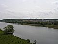
Overlooking the Lower Bann at Coleraine and the Riverside Retail Park on the eastern banks of the river
-
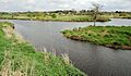
The point of Whitecoat, where the Newry Canal (in the foreground) meets the Upper River Bann
See also
 In Spanish: Río Bann para niños
