
Spelga Reservoir facts for kids
Quick facts for kids Spelga Reservoir |
|
|---|---|
 |
|

Spelga Reservoir
Location in County Down
|
|
| Location | County Down, Northern Ireland |
| Coordinates | 54°10′25″N 6°3′38″W / 54.17361°N 6.06056°W |
| Type | reservoir |
| Catchment area | 1,340 acres (5.4 km2) |
| Basin countries | United Kingdom |
| Water volume | 600×106 imp gal (2,700,000 m3) |
| Surface elevation | ~ 1,200 ft (370 m) |
| Islands | none |
Spelga Reservoir is a large lake built by people in the beautiful Mourne Mountains of County Down, Northern Ireland. It's located in a place called Spelga, which means "full of pointed rocks" in Irish! This reservoir was created by building the Spelga Dam. It sits very high up, about 1,200 ft (370 m) above sea level.
Spelga Reservoir holds a huge amount of water, about 2,700,000 cubic metres. It collects water from an area of 5.423 square kilometres. The reservoir is built in a spot known as Deers Meadow. It holds back the water of the River Bann, which starts its journey on a nearby mountain called Slieve Muck.
Building Spelga Reservoir
The idea to build a reservoir here started a long time ago, in 1894. People in Belfast needed more water. The Spelga Reservoir and its dam were built much later, between 1953 and 1957.
During construction, the B27 road had to be moved. The old road would have been covered by the new lake. So, a new road was built higher up around the reservoir. The dam was designed by engineers from Belfast. A company called John Laing & Sons built it.
Before building started, experts looked for old things in the ground. They found three groups of very old buildings. These were "booley huts," used by people who moved their animals to different pastures. Some huts were from the 1700s. But people think the area was used even earlier, because they found old flint tools.
What Spelga Reservoir is Used For
Spelga Reservoir provides drinking water to many towns. Areas like Portadown and Banbridge get their water from here.
Even though people don't add fish to the reservoir anymore, you can still find wild trout living in its waters.
Sometimes, when the weather is very hot and dry, the water level in the reservoir drops. This happened in 2018 and again in 2020. When the water goes down, you can see parts of the old road that were covered by the lake. You can even see an old bridge! This bridge was once the very first bridge over the River Bann.
Images for kids
-
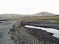
The old bridge and road, exposed during low water levels.
-
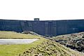
Spelga Dam


