
County Down facts for kids
Quick facts for kids
County Down
|
||
|---|---|---|
|
||
| Nickname(s):
Mourne Country
|
||
| Motto(s): | ||
 |
||
| Country | United Kingdom | |
| Constituent Country | Northern Ireland | |
| Province | Ulster | |
| Established | early 16th century | |
| County town | Downpatrick | |
| Area | ||
| • Total | 961 sq mi (2,489 km2) | |
| Area rank | 12th | |
| Highest elevation | 2,790 ft (850 m) | |
| Population
(2021)
|
553,261 | |
| • Rank | 4th | |
| Time zone | UTC±0 (GMT) | |
| • Summer (DST) | UTC+1 (BST) | |
| Postcode area | ||
| Contae an Dúin is the Irish name, Countie Doun and Coontie Doon are Ulster Scots spellings. | ||

County Down (called Contae an Dúin in Irish) is one of the six counties in Northern Ireland. It's also one of the nine counties in the province of Ulster. This county is one of the 32 traditional counties of Ireland.
County Down covers an area of about 2,489 square kilometers (961 square miles). Over 552,000 people live here. It shares borders with County Antrim to the north and County Armagh to the west. The Irish Sea is to its east.
In the eastern part of the county, you'll find Strangford Lough and the Ards Peninsula. The biggest town is Bangor, which is a city on the northeast coast. Other important towns nearby include Newry, Lisburn, and Belfast. County Down is home to both the southernmost point of Northern Ireland (Cranfield Point) and the easternmost point of Ireland (Burr Point).
In 2018, The Sunday Times newspaper listed some of the best places to live in Britain. Three places in County Down made the list: Holywood, Newcastle, and Strangford. The county has two cities: Newry and Bangor. Bangor became a city more recently, in December 2022.
Contents
- What's in a Name? The Meaning of Down
- A Look Back: County Down's History
- Exploring County Down's Geography
- How the County is Organized
- Getting Around: Transportation
- Sports in County Down
- County Down in Books, Movies, and Songs
- Famous People from County Down
- Cities and Towns in County Down
- Images for kids
- See also
What's in a Name? The Meaning of Down
County Down gets its name from the Irish word dún. This word means "fort" or "fortification." You'll find "dún" in many Gaelic place names. For example, it's in Dundee in Scotland and Donegal in Ireland.
The specific fort that gave the county its name is in the historic town of Downpatrick. This town was originally known as Dún Lethglaise. This means "fort of the green side" or "fort of the two broken fetters."
A Look Back: County Down's History
.jpg)
Long ago, in the 2nd century, a group of people called the Voluntii tribe lived here. From the 400s to 1177, County Down was a main part of the kingdom of Ulaid.
The Vikings often raided Ulaid in the 8th and 9th centuries. But the local people fought back strongly. This stopped the Vikings from building lasting settlements in the area. In 1001, a Viking fleet led by Sigtrygg Silkbeard attacked the region.
The Normans invaded the area in 1177. From the 1180s to the 1600s, many English and Scottish people moved here. In 1569, the Irish Parliament passed a law to turn areas without clear county borders into counties. So, in 1570, a group was sent to map out and name new counties. This included the areas that would become County Down.
During the Plantations of Ireland (16th–17th centuries), people from England and Scotland were settled in the county. Later, during the Williamite War in Ireland (1689–1691), the county saw some fighting. Protestant groups in Down rebelled against King James II. They were defeated and the county came under his control. But later that year, a large army led by Marshal Schomberg arrived. They captured Bangor and cleared the area of King James's troops.
Exploring County Down's Geography

County Down has two important land areas that stick out into the sea. These are the Ards Peninsula and the Lecale peninsula.
The county has a coastline along Belfast Lough to the north. It also has a coast along Carlingford Lough to the south. Both of these loughs connect to the sea. Strangford Lough is a large sea inlet located between the Ards Peninsula and the main part of the county. Part of Lough Neagh, a very large lake, is also in Down.
Smaller lakes include Lough Island Reavy and Castlewellan Lake. You can also find Lough Money and Loughinisland near Downpatrick. In the Mourne Mountains, there are several reservoirs like Silent Valley and Ben Crom Reservoir.
The River Lagan forms most of the border with County Antrim. The River Bann also flows through the southwestern parts of the county. Other rivers include the Clanrye and Quoile.
There are many islands off the coast of Down. These include Mew Island and the Copeland Islands. Gunn Island is off the Lecale coast. Strangford Lough alone has at least seventy islands, and many smaller islets. People even say there are 365 islands in Strangford Lough!
County Down is famous for its beautiful Mourne Mountains. As a popular song says, "The mountains of Mourne sweep down to the sea." Slieve Donard is the highest peak in the Mournes. It stands at 849 meters (2,785 feet) tall. It is the highest mountain in Northern Ireland and in the whole province of Ulster. Another important peak is Slieve Croob, which is 534 meters (1,752 feet) high. The River Lagan starts from Slieve Croob.
Cool Places to Visit

- Saint Patrick is believed to be buried at Down Cathedral in Downpatrick. It is said that St. Brigid and St. Columcille are also buried there.
- Saul, County Down is a special place. It's where Saint Patrick is said to have held his first church service in Ireland.
- The city of Newry has St Patrick's Church. It was built in 1578 and is thought to be Ireland's first ever Protestant church. The Newry Canal was also the first canal of its kind built in the British Isles.
- You can explore Castlewellan Forest Park.
- Cloughmore, also known as "The Big Stone," is a huge 30-ton rock. It sits on Slieve Martin Mountain Ridge, high above Rostrevor village.
- Visit Exploris, the Northern Ireland Aquarium. It's located in Portaferry, right on the shores of Strangford Lough.
- The Old Inn in Crawfordsburn and Grace Neill's in Donaghadee are two of Ireland's oldest inns. Many famous people have stayed at The Old Inn, including C. S. Lewis, who wrote The Chronicles of Narnia.
- Tollymore Forest Park is a great place for outdoor adventures. It's located between Castlewellan and Newcastle.
- Scrabo Tower in Newtownards is a tall monument. It was built to remember Charles Stewart, the 3rd Marquess of Londonderry.
- An area of County Down is known as the Brontë Homeland. This is because Patrick Brontë, the father of famous writers Anne, Charlotte, and Emily, was born here.
How the County is Organized
County Down used to be managed by the Down County Council until 1973. Now, different local councils look after the area. These include:
- Ards and North Down
- Newry, Mourne and Down
- Lisburn and Castlereagh
- Belfast
- Armagh City, Banbridge and Craigavon
Getting Around: Transportation
Trains

In the past, County Down had railway lines like the Great Northern Railway of Ireland. Most of these closed in the 1950s. Today, the Downpatrick and County Down Railway is a special heritage railway. It runs a short section of the old line.
Northern Ireland Railways operates the modern train network in the area.
Sports in County Down
Football (Soccer)
In football, some teams from County Down play in the top league, the NIFL Premiership. These include Newry City F. C., Ards F.C., and Warrenpoint Town F.C.. Other teams like Banbridge Town F.C. and Bangor F.C. play in lower leagues.
Gaelic Games
The Down County Board organizes Gaelic games in the county. Down is very successful in Gaelic football. They have won the All-Ireland Senior Football Championship five times. The Ards Peninsula is especially known for hurling.
Golf
County Down is home to a world-famous golf course. The Royal County Down Golf Club is ranked as one of the best in Ireland and Great Britain.
Rory McIlroy, a former number one golfer in the world, is from Holywood. This town is in the north of the county.
County Down in Books, Movies, and Songs
- "Star of the County Down" is a very popular Irish folk song.
- The county is mentioned in the song "Around the World" from the movie Around the World in 80 Days.
- The singer Van Morrison mentions County Down in several of his songs. These include "Northern Muse (Solid Ground)" and "Coney Island". He also sang "Star of the County Down" with the Chieftains.
- C.S. Lewis, who wrote The Chronicles of Narnia, was inspired by the Mourne Mountains. There's even a Narnia trail in Kilbroney Park in Rostrevor.
- The novel December Bride (1951) by Sam Hanna Bell is set in the Ards Peninsula. A movie version was also made.
- Many parts of County Down have been used as filming locations. The famous TV series Game of Thrones filmed scenes at Castle Ward (Winterfell) and Tollymore Forest Park.
- The Academy Award-winning short film The Shore (2011) was filmed around Killough Bay.
Famous People from County Down
Many well-known people have come from County Down.
- George Best, a famous Northern Ireland footballer.
- The rock band Ash is from Downpatrick.
- Patrick Brontë, the father of the famous Brontë sisters who wrote classic novels.
- Jamie Dornan, an actor known for 50 Shades of Grey, is from Holywood.
- Harry Ferguson, who invented the modern tractor, was from Dromore.
- Bear Grylls, a well-known adventurer and TV personality, grew up in Donaghadee.
- Rory McIlroy, the famous golfer, is from Holywood.
- Kristian Nairn, who played Hodor in Game of Thrones, is from Lisburn.
- Hans Sloane, who founded the British Museum, was from Killyleagh.
- David Trimble, Baron Trimble, a former First Minister of Northern Ireland.
Cities and Towns in County Down
| Historical population | ||
|---|---|---|
| Year | Pop. | ±% |
| 1653 | 13,207 | — |
| 1659 | 15,183 | +15.0% |
| 1821 | 325,410 | +2043.3% |
| 1831 | 352,012 | +8.2% |
| 1841 | 361,446 | +2.7% |
| 1851 | 320,817 | −11.2% |
| 1861 | 299,302 | −6.7% |
| 1871 | 277,294 | −7.4% |
| 1881 | 248,190 | −10.5% |
| 1891 | 224,008 | −9.7% |
| 1901 | 205,889 | −8.1% |
| 1911 | 204,303 | −0.8% |
| 1926 | 209,228 | +2.4% |
| 1937 | 210,687 | +0.7% |
| 1951 | 241,181 | +14.5% |
| 1961 | 266,939 | +10.7% |
| 1966 | 286,631 | +7.4% |
| 1971 | 311,876 | +8.8% |
| 1981 | 417,978 | +34.0% |
| 1991 | 454,411 | +8.7% |
| 2001 | 489,004 | +7.6% |
| 2011 | 531,665 | +8.7% |
| 2021 | 553,261 | +4.1% |
As of the 2021 census, County Down had a population of 552,261 people. This makes it the second most populated county in Northern Ireland.
Main Cities
- Belfast – some eastern parts are in County Down.
- Bangor (now a city).
- Lisburn – some eastern parts are in County Down.
- Newry – this city is partly in County Down and partly in County Armagh.
Large Towns
- Dundonald
- Newtownards
Other Notable Towns
- Banbridge
- Downpatrick
- Holywood
- Carryduff
- Ballynahinch
- Comber
- Donaghadee
- Dromore
- Kilkeel
- Newcastle
- Saintfield
- Warrenpoint
Images for kids
-
The coat of arms for County Down.
-
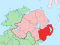
A map showing where County Down is located in Ireland.
See also
 In Spanish: Condado de Down para niños
