
Lecale facts for kids
Quick facts for kids
Lecale
Leath Cathail(Irish)
|
|
|---|---|

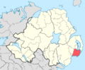
Location of the former barony of Lecale, County Down, in present-day Northern Ireland. It was based on the Irish district of Leath Cathail
|
|
| Sovereign state | United Kingdom |
| Country | Northern Ireland |
| County | Down |
Lecale (which means "Cathal's half" in Irish) is a special area in the east of County Down, Northern Ireland. It's a peninsula, which is land almost surrounded by water. Over time, Lecale has also been the name for different historical areas.
This place is very important for its history and geography. It's bordered by the Irish Sea, Strangford Lough, and what used to be large marshes and a river. Lecale is almost cut off from the rest of the land. This made it easy for people from the east and south to arrive and influence the area.
Long ago, it was known as Leath Cathail, an old Irish district. Later, it was called Ladcathel and was a county in the Earldom of Ulster. Eventually, it became a barony (a type of land division) called Lecale. By 1851, this barony was split into two parts: Lecale Lower and Lecale Upper.
Contents
History of Lecale


Lecale has a rich and long history, with many interesting stories and events.
Ancient Leath Cathail
The ancient area of Leath Cathail included what are now Lecale Lower and Lecale Upper. It was part of the old kingdom of Ulaid. The name comes from Cathal, a prince from around 700 A.D. So, Leath Cathail means "Cathal's half."
Even before that, this area was called Magh Inis, meaning "island plain." People still sometimes call it "Isle Lecale." These names make sense because, until about 200 years ago, Lecale was almost completely surrounded by water. This included Dundrum Bay, Strangford Lough, and the Irish Sea.
A group called the Cenél nÓengusa were kings of Leath Cathail. By the 12th century, the Ua Flathraoi family were important lords. In 1147, a big battle happened near Dún Droma (now Dundrum Bay). The Ulaid people were defeated by the Cenél nEógain. Archu Ua Flathraoi, the "lord of Leath-Chathail," died in this battle. The winners took many treasures and hostages from Lecale.
Dundrum's History
The place called Dún Droma means "fort of the ridge." Today, it is known as Dundrum. A poem from the 1200s mentions it as "the fort of Dairinne's ridge." This poem talks about victories but also sadness over a later defeat.
Dundrum Castle now stands where the old fort was. It is believed that John de Courcy built it for the Knights Templar. They held the castle until 1313 when their group was disbanded. After that, it was given to the head of the Down Abbey.
Saints of Lecale
Lecale is very important in the story of Ireland's saints.
Saint Patrick's Journey
St. Patrick first landed at the Slaney estuary when he returned to Ireland. Today, a large statue of him looks out over the area from Raholp. He passed away at the Abbey of Saul, where he started his mission. Bishop Tassach of Raholp gave him his last communion. St. Patrick's remains were taken to Downpatrick, which is in Lecale Upper.
Relics of Saints Brigid and Columba
The relics (special items) of Brigid of Kildare were brought to Downpatrick in 835. This was to keep them safe from Viking raiders. Columba's relics were also brought here from Iona in 877. Because Downpatrick was often attacked, the relics were buried in the abbey yard and forgotten for a long time.
In 1185, they were rediscovered. John de Courcy had them placed in a new tomb inside the abbey on June 9, 1186.
Protecting the Saints' Grave
In 1538, Lord Leonard Grey damaged the abbey. He was later executed for his actions. The saints' relics seemed to stay safe until 1790. At that time, the building was being rebuilt as Down Cathedral. Sadly, the tomb was damaged, and the relics were scattered. The people of Downpatrick quickly buried them in their current spot.
It is said that a town cross was placed over the grave. However, it was later taken away and damaged. In 1900, the Belfast Naturalists' Field Club put a large granite slab over the grave. This was to protect it because people leaving Ireland often took soil from the grave as a souvenir.
Lecale in Later Times
The Earls of Kildare once controlled the customs at Stangford and Ardglass, both in Lecale Lower. These ports were important for trade. Lecale was a rich area, so John de Courcy made it part of the "Pale" (an area controlled by the English). He gave land to his followers. Later, King Henry VIII gave the income from the port to Gerald Fitzgerald, Earl of Kildare. The Kildare family was connected to Ardglass for 300 years.
Lecale was also known as "Ladcathel" and was one of the seven counties of the Earldom of Ulster in 1333. As mentioned, it was later divided into Lecale Lower and Lecale Upper by 1851.
The Russell family of Downpatrick has lived in Lecale since the 12th century. Thomas Russell, a leader of the United Irishmen, was involved in a rebellion in 1803. He was put in Downpatrick prison and hanged there on October 21, 1803. A famous song called "The Man From God Knows Where" was written about him.
Geography of Lecale
Lecale's geography has changed over time. Until 1745, the sea surrounded almost the entire area. Then, Edward Southwell built sea barriers. This created the River Quoile and added 500 acres of new land around Downpatrick. Today, Strangford Lough is to the north, the Irish Sea to the east, and Dundrum inner bay to the west.
The soil in Lecale is mostly light to medium loam. This type of soil is great for growing grains. Because of this, Lecale is one of the most farmed areas in Northern Ireland. Historically, this was also true. Old records from 1833 to 1837 show that in some areas, like Dunsfort and Ballee, almost all the land was used for growing crops, not for raising animals.
Since there weren't many farm animals, farmers often used marl and lime to enrich the soil instead of manure. In the late 1700s, a writer named Arthur Young noted that Lecale was almost completely covered in grain fields, mostly barley. He also observed that the southern part of Lecale had more fertile soil than the north.
In 1967, a large area of the Lecale Peninsula, about 3,108 hectares, was named the Lecale Coast Area of Outstanding Natural Beauty. This means it's a special place with beautiful landscapes that are protected.
Images for kids
-
Location of Lecale in County Down.
