
Counties of Northern Ireland facts for kids
Quick facts for kids Counties of Northern Ireland |
|
|---|---|
 |
|
| Category | Former local government |
| Location | Northern Ireland |
| Number | Six |
| Populations | 63,585 (Fermanagh) 651,321 (Antrim) |
| Areas | 512 sq mi (1,330 km2) (Armagh) 1,261 sq mi (3,270 km2) (Tyrone) |
| Government | Grand jury (to 1898) / County council (1899–1973) |
| Subdivisions | County district (borough / urban district, rural district) |
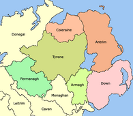
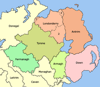
Northern Ireland is made up of six main areas called counties. These are Antrim, Armagh, Down, Fermanagh, Londonderry, and Tyrone. For many years, from 1921 until 1973, these six counties were the main local government areas in Northern Ireland. There were also two large towns, Derry and Belfast, which were like their own special county areas.
These six counties have a long history, dating back to the Kingdom of Ireland. Most were created between 1570 and 1591. County Londonderry was formed a bit later, in 1613. The whole island of Ireland has 32 counties in total. People sometimes call Northern Ireland "the Six Counties" and the Republic of Ireland "the Twenty-Six Counties," especially those who don't agree with Ireland being divided. While the way local government works has changed a lot since 1973, these historic counties are still important for many things and people often identify with them.
Contents
Discover Northern Ireland's Counties
Northern Ireland has six historic counties, each with its own county town. These towns were once important centers for local government and courts. Here's a quick look at each one:
| County | County town | Created | Area | Population (2021) | Fun Facts |
|---|---|---|---|---|---|
| Antrim | Antrim | 1570 | 308,645 hectares (762,680 acres) | 651,321 | Formed after a rebellion. The town of Antrim was never the main administrative center for the county after 1570. |
| Armagh | Armagh | 1571 | 132,698 hectares (327,900 acres) | 194,394 | A small part of it was given to County Louth around 1630. |
| Down | Downpatrick | 1570 | 248,905 hectares (615,060 acres) | 553,261 | Also formed after a rebellion. |
| Fermanagh | Enniskillen | 1588 | 185,097 hectares (457,380 acres) | 63,585 | Its borders were based on the land of the Maguire family. |
| Londonderry | Coleraine | 1613 | 211,826 hectares (523,430 acres) | 252,231 | This county was created by joining several smaller areas together. |
| Tyrone | Omagh | 1591 | 326,550 hectares (806,900 acres) | 188,383 | Its name comes from an old Irish kingdom called Tír Eoghain. |
How the Counties Were Formed
The idea of dividing land into counties came from the English government in Ireland. This process started in the 1200s and continued until the 1600s. The exact shape of the counties in Northern Ireland wasn't decided until after a major event called the Flight of the Earls in 1607. This event allowed the area of Ulster to be fully divided into counties starting in 1604. Each county had a special "county town" where important courts and meetings were held.
The areas that are now County Antrim and County Down were once part of a large area called the Earldom of Ulster. This earldom was created after an English knight, John de Courcy, conquered the area in the 1170s. Over time, this large area was broken down into smaller shires (like mini-counties). However, after a war called the Bruce invasion (1315–1318), much of this earldom was destroyed. By the 1400s, only small parts remained under English control.
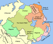
It wasn't until the time of Queen Elizabeth I that more counties were created in Ulster. After a powerful Irish leader, Shane O'Neill, died in 1567, new counties like Antrim and Down were formed. In 1584, another English leader, Sir John Perrott, created six counties in Ulster, including Armagh, Coleraine, Fermanagh, and Tyrone. These new counties were mostly based on the lands of existing Irish lordships. However, these plans didn't fully work until after the Nine Years' War ended and the Plantation of Ulster began. This "Plantation" was a plan to settle new people from England and Scotland in Ulster, which helped to make the county system stronger.
- Development of Northern Ireland's counties
-
Later 15th century – Boundaries of counties and lordships (black border) and minor lordships (grey border) in Ulster.
-
Early 16th century – General boundaries of lordships in Ulster.
-
1584 – General boundaries of the counties of Ulster created by the Lord Deputy of Ireland Sir John Perrott.
-
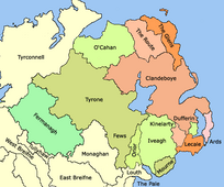
1613 – Ulster after the creation of County Londonderry, from the merger of County Coleraine, the North West Liberties of Londonderry (1), Loughinsholin (2), and North East Liberties of Coleraine (3).


Baronies: Smaller Divisions
Each county in Northern Ireland was also divided into smaller areas called baronies. These baronies were like a step between a county and a parish (a very small local area). Today, baronies are not used for administrative purposes. They were often based on the lands of old Irish chieftains. By the early 1600s, as part of the Plantation of Ulster, these Irish kingdoms were officially turned into baronies. They were then used for things like collecting taxes and keeping records.
Baronies were important for many records from the 1600s to the 1800s, such as surveys and census information.
Lieutenancy Areas: Royal Representatives
Just like other parts of the United Kingdom, Northern Ireland is divided into lieutenancy areas. These are special areas where a Lord Lieutenant is appointed. A Lord Lieutenant is a personal representative of the British monarch (the King or Queen). Northern Ireland has eight lieutenancy areas:
| NI Lieutenancy Area | Current Lord Lieutenant | Year of Appointment |
|---|---|---|
| Lieutenancy of County Londonderry | Alison Millar | 2018 |
| Lieutenancy for the County Borough of Londonderry (in the City of Derry) | Ian Crowe | 2023 |
| Lieutenacy of County Down | Gawn Rowan Hamilton | 2021 |
| County Borough of Belfast Lieutenancy | Dame Fionnuala Jay-O’Boyle | 2014 |
| Lieutenancy of County Armagh | 7th Earl of Caledon | 1989 |
| Lieutenancy of County Antrim | David McCorkell | 2019 |
| Lieutenancy of County Tyrone | Robert Lowry Scott | 2009 |
| Lieutenancy of County Fermanagh | 3rd Viscount Brookeborough | 2012 |
The borders of these lieutenancy areas are the same as the six historic counties and the two special county areas (Belfast and Derry) that were set up in 1898.
Past Counties of Northern Ireland
Some areas that are now part of the six modern counties of Northern Ireland were once counties themselves:
- County Coleraine was created in 1584 and later became the main part of modern County Londonderry.
- Carrickfergus was once a "county of itself," meaning it was a separate county. It was joined with County Antrim in 1899.
- In 1333, the Earldom of Ulster had seven counties: Antrim, Blathewyc, Cragferus (Carrickfergus), Coulrath (Coleraine), del Art, Dun (Down), Ladcathel (Lecale), and Twescard.
- In 1549, Ulster itself was sometimes called a county, with smaller divisions within it.
