
Derry facts for kids
Quick facts for kids Derry / Londonderry
|
|
|---|---|
 From top, left to right: Austin's Department Store, Derry's Walls, Free Derry Corner, Peace Bridge across the River Foyle, a view of Derry at night, Diamond War Memorial, 'Hands Across the Divide' sculpture |
|
 Vita Veritas Victoria "Life, Truth, Victory" (Adapted from a decoration on the Craigavon Bridge) |
|

|
|
| Population |
2021 Census
|
| Irish grid reference | C434166 |
| District |
|
| County | |
| Country | Northern Ireland |
| Sovereign state | United Kingdom |
| Post town | LONDONDERRY |
| Postcode district | BT47, BT48 |
| Dialling code | 028 |
| Police | Northern Ireland |
| Fire | Northern Ireland |
| Ambulance | Northern Ireland |
| EU Parliament | Northern Ireland |
| UK Parliament |
|
| NI Assembly |
|
Derry, officially Londonderry, is a major city in Northern Ireland. It is the second-largest city there and the fifth-largest on the island of Ireland. The old walled city part of Derry is on the west side of the River Foyle. This river has two road bridges and one footbridge connecting its banks. The city now spreads out on both sides of the river.
In 2021, about 85,279 people lived in Derry. The wider Derry Urban Area had a population of 105,066 in 2011. The city is very close to the border with County Donegal. People have had strong connections across this border for hundreds of years. Saint Colmcille, a holy man from Tír Chonaill (which is now County Donegal), is traditionally seen as the person who founded the original settlement of Derry.
In 2013, Derry was chosen as the first-ever UK City of Culture. This was a big honour for the city.
Contents
- What's in a Name? Derry or Londonderry?
- Explore the City Walls
- Derry's Past: A Journey Through Time
- How Derry is Governed
- Derry's Landscape and Weather
- People of Derry
- Derry's Economy: How People Make a Living
- Famous Landmarks and Attractions
- Getting Around Derry
- Learning in Derry
- Sports and Fun in Derry
- Derry's Culture and Events
- Famous People from Derry
- Images for kids
- See also
What's in a Name? Derry or Londonderry?


The city has two names: Derry and Londonderry. The name Derry comes from the Irish word Doire, which means 'oak-grove' or 'oak-wood'. This name was used because the first settlement was in an area with many oak trees.
In 1613, during a time called the Plantation of Ulster, the name was changed to Londonderry. This happened when groups from London helped to rebuild and settle the city.
Today, people often use both names. Many nationalists and most people in the Republic of Ireland prefer Derry. Many unionists prefer Londonderry. However, in daily talks, most people living in the city, including Protestants, often say Derry.
Official signs in the Republic of Ireland usually say Derry. In Northern Ireland, road signs say Londonderry, but sometimes the "London" part is covered up. Many local groups use one name or the other. For example, there's the City of Derry Airport and the Londonderry Port.
The city is also called "the Maiden City". This is because its walls were never broken through during attacks in the 1600s. The most famous attack was the Siege of Derry in 1688–1689. Another nickname is "Stroke City," because some people use "Derry/Londonderry" to include both names.
Explore the City Walls


Derry is special because it's the only city in Ireland with its old city walls still completely standing. These walls are some of the best in Europe! They are the largest historical monument cared for by the government in Northern Ireland.
The walls were built between 1613 and 1619. They were made by a group called The Honourable The Irish Society to protect new settlers from England and Scotland. The walls are about 1 mile (1.6 km) long and vary in height and width. You can walk all the way around the inner city on top of them. This walk gives you a great view of the old town, which still has its original street plan from the Renaissance period.
There were four original gates into the walled city: Bishop's Gate, Ferryquay Gate, Butcher Gate, and Shipquay Gate. Later, three more gates were added: Magazine Gate, Castle Gate, and New Gate. This makes seven gates in total.
Because the walls were never broken through, even during the 105-day Siege of Derry in 1689, the city earned its nickname, The Maiden City.
Derry's Past: A Journey Through Time

Derry is one of the oldest places in Ireland where people have lived continuously. The first records of the city are from the 6th century. This is when a monastery was started by Saint Columba (also known as Colmcille). He was a famous saint from what is now County Donegal. People had lived in this area for thousands of years before that.
Early Days and the Monastery
Before he left Ireland, Colmcille founded a monastery in Derry, then called Doire Calgach. A local king gave him the land. The monastery was important for many centuries, from the 6th to the 11th century.
Later, during the Tudor conquest of Ireland, the town became very important for military reasons and was often attacked. In 1608, an Irish leader named Sir Cahir O'Doherty attacked and burned much of the town. Sir Henry Docwra worked hard to rebuild the town and is sometimes called "the founder of Derry."
The Plantation of Ulster
Before 1610, the area that became Derry was part of County Donegal. In 1610, the English Crown gave the west side of the future city to The Honourable The Irish Society. This area was then joined with other counties to form County Londonderry.
In the 17th century, settlers from London, called "planters," arrived as part of the Plantation of Ulster. They rebuilt the town with strong walls to protect it. The goal was to settle Ulster with people who supported the Crown. This is when the city was renamed "Londonderry."
This new city was the first planned city in Ireland. Building started in 1613, and the walls were finished in 1619. The design, with a central square (called the Diamond) and four main streets leading to four gates, was good for defense. This design was later copied in British colonies in North America.
The oldest building still standing in the city, St Columb's Cathedral, was built around this time in 1633.
Wars and Sieges in the 1600s
In the 1640s, Derry faced many challenges during the Wars of the Three Kingdoms. Irish rebels attacked the city in 1641 but failed. In 1649, the city was under siege by Scottish forces.
The most famous event was the Siege of Derry in 1688–1689. This happened during the Glorious Revolution. Derry was one of the few Protestant-held places left. An army tried to take the city, but the gates were closed against them. King James himself came to demand surrender, but the city refused. The siege lasted for 105 days until a relief ship arrived.
Growth in the 1700s and 1800s
The city was rebuilt in the 18th century, and many beautiful Georgian-style houses from that time still exist. The first bridge across the River Foyle was built in 1790.
During the 18th and 19th centuries, Derry's port became a very important place for Irish people leaving for North America. Many people also came to Derry during the Great Famine in the 19th century, seeking a better life.
The 20th Century and World Wars
World War I
During World War I, over 5,000 men from Derry, both Catholic and Protestant, joined the British Army.
Partition of Ireland

After the Anglo-Irish Treaty in 1921, Ireland was divided. Derry unexpectedly became a 'border city', cut off from some of its traditional trading areas in County Donegal. Before this, in 1920, there was serious fighting between different groups in the city. Many people died, and many were forced to leave their homes.
World War II
During World War II, Derry played a very important role in the Battle of the Atlantic. This was a long fight at sea. Ships from the Royal Navy, Royal Canadian Navy, and other Allied navies were based in Derry. The United States military also set up a base here. Derry was the westernmost Allied port in Europe, making it a key starting point for convoys of ships traveling between Europe and North America.
This military presence changed the city a lot, bringing new people and boosting the economy. Several airfields were built nearby, and RAF Eglinton later became City of Derry Airport.
At the end of World War II, about 60 German U-boats (submarines) surrendered in Derry's harbour at Lisahally.
The Civil Rights Movement and The Troubles

After World War II, Derry faced problems like unemployment. A campaign to have Northern Ireland's second university in Derry failed, which caused disappointment.
Derry became a key place for the civil rights movement in Northern Ireland. Many Catholics felt they were treated unfairly by the government in Northern Ireland, especially in politics and jobs. In the late 1960s, people protested against these unfair practices.
A civil rights march in 1968 was banned by the government and stopped by the police. In August 1969, events after a parade led to the Battle of the Bogside. This was when Catholic rioters fought the police, and it is often seen as the start of the Troubles.
On 30 January 1972, a tragic event known as Bloody Sunday occurred. Thirteen unarmed civilians were shot and killed by British soldiers during a civil rights march in the Bogside. Another 13 were wounded, and one more person later died from their injuries.

The conflict known as the Troubles is widely thought to have begun in Derry. In the early 1970s, the city was heavily guarded by military forces, and there was a lot of unrest. Some areas built barricades to control who could enter.
Violence began to decrease towards the end of the Troubles in the late 1980s and early 1990s. By this time, Derry saw less bloodshed than other places like Belfast.
How Derry is Governed
Since 2015, Derry has been governed by the Derry and Strabane District Council. This council was formed by merging the old Derry City Council with the Strabane district council. The council members are elected every four years.
City Symbols: Coat of Arms and Motto

The city's coat of arms shows a skeleton and a castle with three towers on a black background. The top part of the shield shows the arms of the City of London: a red cross and a sword on white. In the middle of the cross is a gold harp.
These arms were officially approved in 1613. The skeleton is said to represent the city's ruin after an attack by an Irish rebel named Cahir O'Doherty. The silver castle shows how the city was rebuilt by the London groups. The motto on the coat of arms is in Latin: "Vita, Veritas, Victoria," which means "Life, Truth, Victory."
Derry's Landscape and Weather


Derry is known for its hilly landscape. The River Foyle flows through the city in a deep valley, making the area quite steep. The original walled city is on a hill on the west bank of the river.
Today, Derry has grown much larger, extending north, west, and east of the river. The part of the city on the west side of the Foyle is called the Cityside, and the area on the east is called the Waterside. The Craigavon Bridge, Foyle Bridge, and the Peace Bridge connect these two sides.
The city has a mild, wet climate, typical of Ireland. It doesn't get too hot or too cold.
People of Derry

Derry is a city with a diverse population. In the 2021 census, there were 85,279 people living in Derry City.
- About 21% were under 16 years old.
- About 78% of people were from a Catholic background.
- About 17% were from a Protestant and Other Christian background.
- About 65% said they had an Irish national identity.
- About 22% said they had a Northern Irish national identity.
- About 17% said they had a British national identity. (People could choose more than one identity).
- About 16% had some knowledge of the Irish language.
Working Together
In the past, there have been concerns about different communities living separately in the city. However, local leaders and community groups are working hard to bring people together and promote understanding and tolerance. They want everyone to feel welcome and part of the city.
Derry's Economy: How People Make a Living

In the past, Derry's economy was largely based on the textile industry, especially shirt making. This industry was very important, and Derry was known for its shirts around the world. At its peak in the 1920s, about 18,000 people worked in shirt factories. However, the textile industry declined due to lower wages in other countries.
Today, Derry's economy has changed. Large international companies have invested in the city. For example, Du Pont has had a factory at Maydown since 1958, making materials like Kevlar. Seagate, an American company, has also had a factory in Derry since 1993, employing many people.

Some people have raised concerns that government investment in the city's economy and infrastructure has not been enough compared to other areas. However, there are ongoing efforts to boost economic growth, including cross-border projects with the Republic of Ireland.
Shopping in Derry
Derry is a major shopping area for the North West region. It has two large shopping centres: the Foyleside Shopping Centre and the Richmond Centre. There are also many other shops and a large retail park called Crescent Link.
Until 2016, Derry was home to Austins, which claimed to be the world's oldest independent department store. It was established in 1830.
Famous Landmarks and Attractions


Derry is famous for its beautiful buildings and history. The historic walled city, with its central Diamond and streets leading to the city gates, is a great example of old city planning. St Columb's Cathedral is a very old church built in 1633. The Roman Catholic St Eugene's Cathedral is another important church built in the 19th century.
The city walls are a continuous walkway around the city centre. You can see old cannons and enjoy views across Derry. Other historic buildings include St Augustine's Church and the impressive Bishop Street Courthouse. The red-brick Guildhall, with its copper dome, is also a well-known landmark near the river.
There are many interesting places to visit in Derry:
- The Foyle Valley Railway Centre
- The Amelia Earhart Centre And Wildlife Sanctuary
- The Apprentice Boys Memorial Hall
- The Bogside area with its famous murals by the Bogside Artists
- Derry Craft Village
- Free Derry Corner
- O'Doherty Tower (part of the Tower Museum)
- The Harbour Museum
- The Museum of Free Derry
- The Nerve Centre
- St. Columb's Park and Leisure Centre
- Creggan Country Park
- Brooke Park
- The Millennium Forum (a theatre)
- The Void Gallery
- The Foyle and Craigavon bridges
Lonely Planet even called Derry the fourth best city in the world to visit in 2013!
On 25 June 2011, the Peace Bridge opened. This special bridge is for walking and cycling. It connects the Guildhall in the city centre to Ebrington Square and St Columb's Park across the River Foyle. It was built to help bring communities together.

Getting Around Derry

Derry has a network of roads and railways. Two bridges, the Craigavon Bridge and the Foyle Bridge (the longest bridge in Ireland), help traffic cross the River Foyle. Derry is also a key transport hub for traveling to nearby County Donegal.
Buses
Most public transport in Northern Ireland is run by Translink. In Derry, the local bus network is operated by Ulsterbus Foyle. Buses connect the city centre to suburban areas. Long-distance buses also leave from Foyle Street Bus Station, going to places across Ireland like Belfast and Dublin.
Air Travel
City of Derry Airport, located near Eglinton, serves the city and surrounding areas, including County Donegal. It has flights to various cities in the UK like Glasgow Airport, Edinburgh Airport, Manchester Airport, Liverpool John Lennon Airport, and London Stansted.
Trains
The city has one train line that ends at Derry ~ Londonderry railway station in Waterside. This line mainly carries passengers from Derry to Belfast, with stops along the way. In the past, Derry had more train lines connecting it to different parts of Ireland, but most closed down due to competition from roads. There are plans to improve the train line to Belfast to make journeys faster.

Historically, several railway companies operated around Derry in the mid-1800s, connecting the city for passengers and goods. However, after the partition of Ireland in 1922, border checks caused delays. By the mid-20th century, most lines closed due to more people using roads. The line to Coleraine became the only one left.
Learning in Derry

Derry is home to the Magee Campus of Ulster University. This campus has about 4,400 students. There was a big debate in the 1960s about where to put Northern Ireland's second university. The decision to build it in Coleraine instead of Derry was a major factor that contributed to the start of the civil rights movement.
The North West Regional College is also in the city, with over 10,000 students each year.
Derry has many secondary schools, including Foyle College, which was founded in 1616 and is one of the oldest in Northern Ireland. Other schools include St. Columb's College, Oakgrove Integrated College, St Cecilia's College, St Mary's College, St. Joseph's Boys' School, Lisneal College, Thornhill College, Lumen Christi College, and St. Brigid's College.
Sports and Fun in Derry

Derry is a city that loves sports! Both soccer (association football) and Gaelic football are very popular.
Soccer
Derry's main soccer team is Derry City, which plays in the national league of the Republic of Ireland. Other local clubs include Institute, Maiden City, and Trojans. The city also hosts the annual Foyle Cup youth soccer tournament, which attracts teams from around the world.
Gaelic Football
In Gaelic football, Derry GAA is the county team. There are many Gaelic games clubs in and around the city, like Na Magha CLG and Steelstown GAC.
Other Sports
- Boxing: The Ring Amateur Boxing Club is well-known, linked to boxers like Charlie Nash and John Duddy.
- Rugby: City of Derry Rugby Club is a popular team.
- Basketball: North Star Basketball Club is the city's only basketball club.
- Cricket: Two cricket clubs, Brigade Cricket Club and Glendermott Cricket Club, play in the local league.
- Golf: There are two golf clubs: City of Derry Golf Club and Foyle International Golf Centre.
Derry's Culture and Events

Derry has a rich culture, known for its artists and writers. Famous people from the area include Nobel Prize-winning poet Seamus Heaney and playwright Brian Friel. The city is also home to bands like the Undertones.
The large political murals by the Bogside Artists, Free Derry Corner, the Foyle Film Festival, the Derry Walls, and the annual Halloween street carnival are popular attractions. In 2010, Derry was named the UK's tenth 'most musical' city.

In May 2013, a special Peace Flame Monument was unveiled. It was lit by children from both communities in the city and is one of only 15 such flames worldwide.
Media
Derry has local newspapers like the Derry Journal and the Londonderry Sentinel. There are also radio stations, including BBC Radio Foyle and Q102.9.
Nightlife
The city's nightlife is lively, especially on weekends, with many pubs and clubs. Waterloo Street and Strand Road are popular areas for live music and entertainment.
Events
- In 2013, Derry was the first city to be named UK City of Culture.
- Also in 2013, the city hosted Radio 1's Big Weekend and the Lumiere light festival.
- The "Banks of the Foyle Hallowe'en Carnival" is a huge event, known as Ireland's first and longest-running Halloween carnival. More than 30,000 people join the street party every year.
- The city hosts the Big Tickle Comedy Festival in March and the City of Derry Jazz and Big Band Festival in April.
- The Foyle Film Festival, the biggest film festival in Northern Ireland, takes place in November.
- The Siege of Derry is remembered annually during the week-long Maiden City Festival.
- Celtronic is a major annual electronic dance festival.
- The Millennium Forum is the main theatre in the city, hosting many shows.
- In 2007, Derry set a Guinness World Record when 13,000 Santas gathered in the city!
Famous People from Derry
,_August_2009.JPG)
Many notable people were born or have lived in Derry, including:
- James Burke, a science historian.
- Amanda Burton (born 1956), an actress.
- William C. Campbell (born 1930), a scientist and Nobel Prize winner.
- Nadine Coyle (born 1985), a singer.
- Dana (born 1950), a singer and politician.
- Seamus Deane (1940–2021), a poet and novelist.
- Roma Downey (born 1960), an actress.
- Shane Duffy (born 1992), a footballer.
- Neil Hannon (born 1970), a singer.
- Seamus Heaney (1939–2013), a poet and Nobel Prize winner.
- John Hume (1937–2020), a politician and Nobel Prize winner.
- James McClean (born 1989), a footballer.
- Martin McGuinness (1950–2017), a politician.
- Feargal Sharkey (born 1958), lead singer of The Undertones.
- Leah Totton (born 1989), a doctor and winner of The Apprentice.
Images for kids
-
Unionist graffiti from around 1920, showing a short version of the city's name.
-
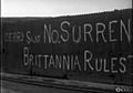
"No Surrender" mural outside the city wall, photographed in 2004.


See also
 In Spanish: Derry para niños
