
River Foyle facts for kids
Quick facts for kids River Foyle |
|
|---|---|

|
|
| Native name | An Feabhal |
| Jurisdiction | Republic of Ireland, Northern Ireland |
| Counties | Tyrone, Londonderry, Donegal |
| Cities | Derry |
| Physical characteristics | |
| Main source | River Mourne Newtownstewart 54°43′16″N 7°21′54″W / 54.721°N 7.365°W |
| 2nd source | River Finn Lough Finn 54°51′32″N 8°08′06″W / 54.859°N 8.135°W |
| River mouth | Lough Foyle 55°06′25″N 7°04′44″W / 55.107°N 7.079°W |
| Length | 129 km (80 mi) |


The River Foyle is a river in the northwest of Ireland. It starts where two other rivers, the River Finn and the River Mourne, meet. This meeting point is near the towns of Lifford in County Donegal, Republic of Ireland, and Strabane in Northern Ireland. From there, the Foyle flows all the way to the city of Derry. Finally, it empties into Lough Foyle and then into the Atlantic Ocean.
The River Foyle is about 129 kilometers (80 miles) long. It acts like a natural border, separating parts of County Donegal from parts of County Londonderry and County Tyrone. The area of County Donegal along the western side of the river is known as the Laggan. This area includes small villages like St. Johnston and Carrigans, which are right on the riverbanks.
Contents
Understanding the River Foyle
Where Did the Name Foyle Come From?
The name of the River Foyle has a long history. An ancient writer named Ptolemy described a river mouth called Widua way back in the 2nd century AD. This was likely the Foyle.
The Irish name for the river is An Feabhal. This name comes from a mythical figure named Febail, who was the father of Bran in an old Irish story called The Voyage of Bran.
Rivers that Join the Foyle
Many smaller rivers and streams, called tributaries, flow into the River Foyle. These add to its water and flow.
- The Burn Dale (also known as the River Deele) joins the Foyle just outside Lifford.
- The Swilly Burn flows into the Foyle near Porthall, a small village between St. Johnston and Lifford.
- St. Johnston Burn flows into the Foyle right at St. Johnston.
- Flushtoun Burn joins the river just south of St. Johnston.
- Carrigans Burn flows from Port Lough and enters the Foyle near Carrigans.
- Both the Burn Dennet and the Glenmornan River flow into the Foyle north of Ballymagorry.
Bridges Crossing the Foyle
Building bridges across the River Foyle can be tricky because it's one of the fastest-flowing rivers in Europe for its size. In the city of Derry, there are three main bridges that cross the river.
Craigavon Bridge: The Double-Decker Bridge
The oldest bridge in Derry is the Craigavon Bridge. It's special because it's Europe's only road bridge with two levels, like a double-decker bus! People sometimes call it the Blue Bridge.
Foyle Bridge: The Big Bridge
The Foyle Bridge is much larger and is the bridge furthest north in Derry. It was built to be very tall so that big ships could pass underneath. However, the main port later moved further north, so those large ships never really needed to come this far up the river. The Foyle Bridge was planned to help with traffic, but it wasn't built until the 1980s.
Peace Bridge: A Symbol of Unity
Derry's newest bridge is the Peace Bridge, which opened in 2011. It's a bridge just for people walking and cycling. It was built to be a symbol of peace and to connect the two sides of the city. You can find it behind the Guildhall Square, north of the Craigavon Bridge.
Lifford Bridge: Connecting Towns
Outside of Derry, the only other bridge crossing the Foyle is the Lifford Bridge. It was built in the 1960s. This bridge connects Lifford, which is the main town of County Donegal on the west side of the river, with Strabane, a big town in County Tyrone on the east side.
The part of the Foyle that is affected by the ocean's tides can be used by boats for about 16 kilometers (10 miles) inland. There was once a canal, the Strabane Canal, that continued even further, but it is no longer used.
Today, most of the boats on the Foyle, especially south of the northern bridge, are pleasure boats. Sometimes, a tanker might come to the oil refinery near the northern end of Derry. There used to be a small cruise ship called the Toucan One that offered tours from Derry city center to Greencastle on Lough Foyle. However, these tours stopped due to a lack of funding.
Fishing in the River Foyle
The River Foyle is known as one of the best rivers in Ireland for catching salmon. Before the Plantation of Ulster (a time when many people from England and Scotland moved to Ireland), the fishing rights belonged to local Irish leaders. Later, a group called The Honourable The Irish Society took over these rights.
In the 1940s, there was a legal case about fishing rights on the river. Eventually, the governments of the Republic of Ireland and Northern Ireland bought the fishing rights. This led to the creation of the Foyle Fisheries Commission in 1952, which managed fishing on the Foyle and Lough Foyle. This commission was replaced in 2007 by the Foyle & Carlingford Fisheries Act.
If you want to go fishing on the Foyle, you can find information about the rules from the Loughs Agency. The village of St. Johnston, located on the County Donegal side of the river, is a very important fishing spot on the Foyle.
Special Area for Nature: River Foyle and Tributaries ASSI
The River Foyle and its smaller rivers are part of a special protected area called an Area of Special Scientific Interest (ASSI). This area includes parts of the River Finn, the River Mourne, and its tributary the River Strule, as well as the River Derg and some of its smaller streams.
This protected area covers about 120 kilometers (75 miles) of waterways. It's important because of its natural banks and channels, especially in the upper parts of the rivers. It also has a rich variety of plants and animals. One of the most important features is its large population of Atlantic salmon, which is one of the biggest in Europe. Studies have shown that different parts of the river system have their own unique groups of salmon.
Railways Along the River Foyle
The Belfast-Derry railway line runs along the riverbank, providing an important connection to the city of Derry. Northern Ireland Railways trains carry passengers along the shoreline of Lough Foyle from stations like Coleraine and Belfast Central.
_Railway_Station_-_geograph.org.uk_-_746432.jpg)
Images for kids
-
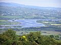
River Foyle from Holly Hill, near Strabane.
See also
 In Spanish: Foyle para niños
