Lough Foyle facts for kids
Quick facts for kids Lough Foyle/Loch Foyle |
|
|---|---|

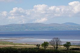
From south shore
|
|
 |
|
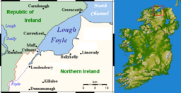
| Location | Republic of Ireland – United Kingdom border |
| Coordinates | 55°07′00″N 7°05′00″W / 55.116667°N 7.083333°W |
| Native name | Loch Feabhail Error {{native name checker}}: parameter value is malformed (help) |
| River sources | River Foyle, River Roe, River Faughan |
| Ocean/sea sources | Atlantic Ocean, Irish Sea |
| Basin countries | Northern Ireland, Republic of Ireland |
| Settlements | Ballykelly, Derry, Greencastle, Magilligan, Moville, Muff |
| Designated: | 2 February 1999 |
| Reference #: | 974 |
Lough Foyle, also known as Loch Foyle, is a large bay or estuary (where a river meets the sea) on the north coast of Ireland. It's where the River Foyle flows into the Atlantic Ocean. This beautiful lough sits between County Londonderry in Northern Ireland and County Donegal in the Republic of Ireland. Since Ireland was divided, who owns the water in Lough Foyle has been a topic of discussion.

Contents
Lough Foyle: A Special Place for Nature
Lough Foyle is a very important natural area. It's recognized as a Ramsar site, which means it's a wetland of international importance. This special status was given on February 2, 1999. The site covers a huge area of 2204.36 hectares.
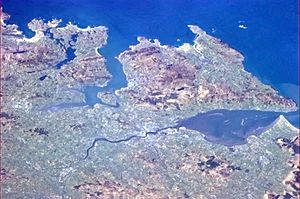
The lough is a shallow sea bay that includes the mouths of the River Foyle, River Faughan, and River Roe. It has large areas of mudflats and sandflats that appear at low tide, along with salt marshes.
Lough Foyle is important for several reasons:
- It plays a big role in how water moves and how plants and animals live in a major river system. This is especially true because it's located on the border between two countries.
- It's home to many rare, vulnerable, or endangered types of plants and animals. For example, special fish like allis shad, twait shad, smelt, and sea lamprey have been found here. These fish are listed as needing protection in Ireland.
- Many Atlantic salmon travel through Lough Foyle to reach their spawning grounds (where they lay their eggs).
The lough also supports a large number of waterfowl (birds that live near water) in winter. This includes a lot of whooper swans, light-bellied brent gooses, and bar-tailed godwits, which are important populations worldwide. Other important birds found here include red-throated divers, great crested grebes, mute swans, Bewick's swans, greylag gooses, shelducks, common teals, mallards, Eurasian wigeons, common eiders, and red-breasted mergansers.
Many wading birds are also important to Lough Foyle, such as Eurasian oystercatchers, Eurasian golden plovers, grey plovers, lapwings, red knots, dunlins, Eurasian curlews, common redshanks, and greenshanks.
Plants and Animals of Lough Foyle
Flora (Plants)
A detailed study of the plants in Lough Foyle was done by Helen Blackler between 1937 and 1939. She created a map showing where different types of algae grew in the lough. Her list included various kinds of algae like blue-green algae, green algae, brown algae, and red algae. She also found lichens and two types of Zostera, which are seagrasses. More information about the marine algae of Lough Foyle can be found in a book by Morton (2003).
Fauna (Animals)
The Royal Society for the Protection of Birds (RSPB) has a special reserve at Lough Foyle. This reserve helps protect the many birds that live in or visit the lough.
Getting Around Lough Foyle
Canals
In 1792, the four-mile-long Strabane Canal was built. It connected the tidal waters of Lough Foyle at Leck to the town of Strabane. However, the canal stopped being used in 1962. There was an effort to restore part of it in 2006, but by 2010, the work wasn't considered good enough, and the local council decided not to keep maintaining it.
Another canal, the Broharris Canal, was built in the 1820s. This canal, about two miles long, was made on the south shore of Lough Foyle near Ballykelly. It helped drain water from the land and also allowed boats to travel. Goods were brought from Londonderry Port, and shellfish and kelp (a type of seaweed) were collected from the sandbanks along the shore.
Ferry Service
During the summer, you can take a ferry across Lough Foyle. This ferry connects Greencastle in County Donegal with Magilligan in Northern Ireland.
Railway Travel
Northern Ireland Railways runs a train line along the beautiful shore of Lough Foyle. From the train, you can enjoy views of Inishowen in County Donegal and the Atlantic Ocean. The train travels from Londonderry railway station to Belfast Central and Great Victoria Street, passing through Coleraine.
This train line, called the Belfast–Derry line, is very important and is being improved. The upgrades will allow for more frequent trains and faster services by improving the tracks and signals.
After leaving Londonderry, the next stops are Bellarena and then Castlerock, before reaching Coleraine. If you get off the train at Castlerock, you can walk to Mussenden Temple, a famous building owned by the National Trust. From there, you can see the mouth of Lough Foyle and Greencastle in County Donegal in the distance.
Lough Foyle in Books
The main character in Alfred Bester's well-known science-fiction novel, The Stars My Destination, is named Gulliver Foyle. Alfred Bester chose the names for his characters from different places in Ireland and Great Britain.
Lough Foyle During the World Wars
First World War
During the First World War, the United States Navy set up a base called Naval Air Station Lough Foyle on the Inishowen side of the lough. This happened on July 1, 1918. The base was used for seaplanes. It closed soon after the war ended.
Second World War
At the end of the Second World War, after the Allied forces won, the remaining German U-boats (submarines) were gathered in Lough Foyle. These U-boats had been used to attack supply ships during the Battle of the Atlantic. As part of something called Operation Deadlight, these U-boats were sunk on purpose in the lough.
Who Owns Lough Foyle?
Lough Foyle is a place where the ownership is still discussed between the Republic of Ireland and the United Kingdom. After Ireland was divided in the early 1920s, both sides said that the lough belonged to them. This discussion is still ongoing, but there are no current talks about it.
The UK's Foreign and Commonwealth Office (FCO) stated on June 2, 2009, that they believe all of Lough Foyle is part of the United Kingdom. A spokesperson said that the Irish Government does not agree with this. However, they also mentioned that a cross-border group called the Loughs Agency, set up under the Good Friday Agreement, is now in charge of managing activities in the lough.
In November 2016, James Brokenshire, who was the UK's Secretary of State for Northern Ireland, repeated the UK's view that all of Lough Foyle is in the UK. At the same time, Charles Flanagan, who was the Republic of Ireland's Minister for Foreign Affairs, said that the Republic of Ireland does not agree with Britain's claim to the entire lough.
See also
 In Spanish: Lough Foyle para niños
 | Audre Lorde |
 | John Berry Meachum |
 | Ferdinand Lee Barnett |

