
Lough Swilly facts for kids
Quick facts for kids Lough Swilly |
|
|---|---|
 |
|

Location in island of Ireland
|
|
| Location | County Donegal, Ireland |
| Coordinates | 55°08′17″N 7°29′56″W / 55.138°N 7.499°W |
| Native name | Loch Súilí Error {{native name checker}}: parameter value is malformed (help) |
| Primary inflows | River Swilly |
| Settlements | Inishowen |

Lough Swilly (Irish: Loch Súilí, meaning meaning "Lake of Shadows" or "Lake of Eyes") is a long, narrow sea inlet in County Donegal, Ireland. It's like a deep valley filled with seawater. This special place lies between two peninsulas: the Inishowen Peninsula and the Fanad Peninsula.
Lough Swilly is one of only three glacial fjords in Ireland. A fjord is a long, narrow, deep inlet of the sea between high cliffs. They are formed by glaciers that carved out the land during the Ice Age. The other two Irish fjords are Carlingford Lough and Killary Harbour.
Contents
Exploring Lough Swilly's Geography
Lough Swilly is located in County Donegal. At its northern end, you'll find Fanad Head with its famous lighthouse and Dunaff Head. These mark the entrance to the lough from the open sea.
Several towns are located along the shores of Lough Swilly. These include Buncrana on the Inishowen side and Rathmullan on the western side. At the very southern tip of the lough is the town of Letterkenny.
Islands and Wetlands
In the southern part of Lough Swilly, there were once several islands. These included Burt, Inch, Coney, and Big Isle. During the 1800s, these islands were connected to the mainland. This was done by building walls called polders and reclaiming land for farming.
The Londonderry and Lough Swilly Railway also built embankments here. Today, these reclaimed lands are important wetlands. They are protected areas for wildlife conservation and are great for birdwatching.
Amazing Wildlife
These wetlands are home to many birds. Over 4,000 whooper swans visit them. Thousands of different types of geese also gather here. You can see Greenland white-fronted geese, barnacle geese, greylag geese, and brent geese.
Lough Swilly is also known for its marine wildlife. You might spot dolphins, porpoises, and many different seabirds. It's a popular spot for divers too. They explore several shipwrecks, including the SS Laurentic. This ship sank in 1917 after hitting a German mine. It was carrying 3,211 gold bars, and almost all of them (3,191) were recovered!
Lough Swilly Through History
Lough Swilly has a very long and interesting history. It was even shown on Ptolemy's ancient map of the world. The Grianán Ailigh hill fort, a very old fortification, is located near the lough. This fort dates back thousands of years, to between 2000 and 5000 BC.
Along the shores of Lough Swilly, you can find signs of early human life. There are Stone Age monuments and Iron Age forts. People have lived here for a very long time. Scientists have also found ancient shell middens, which are piles of shells left by early humans, dating back to about 7000 BC.
The Flight of the Earls
Lough Swilly is famous as the departure point for the 'Flight of the Earls' in 1607. This was a very important event in Irish history. Two powerful Irish chieftains, Hugh O'Neill, 2nd Earl of Tyrone and Rory O'Donnell, 1st Earl of Tyrconnell, left Ireland from Rathmullan on Lough Swilly. They sailed away with about ninety of their followers. This event marked the end of the old Gaelic way of life in Ireland.
Because of its natural shelter and deep waters, Lough Swilly was a very important naval port. In 1798, during the time of the Napoleonic Wars, a French fleet arrived. They were carrying Wolfe Tone and troops to help with the Irish rebellion of 1798. However, the British Navy stopped them in a naval battle at the entrance to Lough Swilly. Wolfe Tone was captured and brought ashore at Buncrana.
After this event, people realized how important it was to protect Lough Swilly. So, between 1800 and 1820, many forts were built around the lough. These forts were designed to guard against invasions.
Martello Towers
Around 1804, Martello towers were built to defend the approaches to Derry. Six of these towers were built around Lough Swilly. They were armed with cannons to fire at enemy ships.
World War Forts
Before World War I, the old forts were improved. New, more powerful guns were added. A new fort was also built at Lenan Head, at the entrance to the lough. It had very large guns that could shoot up to 12 miles. The remains of these forts can still be seen today at places like Lenan Head Fort, Fort Dunree (which is now a museum), Ned's Point, Buncrana, Inch Fort, and on the west coast at Rathmullan, Knockalla, and Macamish Point.
Lough Swilly in the World Wars
During World War I, the British Royal Navy used Lough Swilly as a safe place for its large fleet of warships. It was also a gathering point for convoys of ships crossing the Atlantic Ocean. To protect against German U-boat attacks, a large boom (a barrier) was placed across the lough.
After the Irish War of Independence, Lough Swilly was one of the "Treaty Ports" that remained under British control for a time. It was finally handed over to Ireland at Fort Dunree in 1938.
During World War II, Ireland remained neutral. Irish soldiers manned the guns at Fort Dunree. They had orders to fire at any ship that threatened Ireland's neutrality by entering the lough. There was one incident when a British Royal Navy ship entered the lough and didn't respond to warnings. However, the ship turned around before the Irish forces had to fire.
See also
 In Spanish: Fiordo Swilly para niños
Images for kids
-
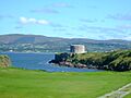
A Martello tower that sits on the banks of Lough Swilly.

