
Killary Harbour facts for kids
Quick facts for kids Killary Harbour |
|
|---|---|

Satellite image of Killary Harbour.
|
|
| Lua error in Module:Location_map at line 420: attempt to index field 'wikibase' (a nil value). | |
| Location | County Galway County Mayo. |
| Ocean/sea sources | Atlantic Ocean. |
| Basin countries | Ireland |
| Max. length | 16 km (9.9 mi) |
| Average depth | 45 m (148 ft) |
| Settlements | Rossroe, Leenaun |
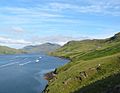
Killary Harbour (which is An Caoláire Rua in Irish) is a long, narrow inlet of the sea in western Ireland. It is often called a fjord, which is a deep, narrow sea inlet with steep sides, usually formed by glaciers. Killary Harbour is located in northern Connemara, and the border between Galway and Mayo runs right through its middle.
Contents
Exploring Killary Harbour's Shape
Killary Harbour is like a long, flooded valley. It stretches for about 16 kilometres (9.9 mi) and is quite deep in the middle, reaching over 42–45 metres (138–148 ft). The sea level outside its mouth is higher, which is typical for a fjord.
How the Harbour Bends
For almost half its length, Killary Harbour runs southeast from the Atlantic Ocean. Then, it makes a turn and goes directly east. It gets narrower after the Bundorragha River flows into it, but then widens near the village of Leenaun. At its very end, it becomes very narrow again before opening up where a small river joins from the south. The harbour finally ends where the Erriff River valley begins. The Erriff River itself flows north and then turns south to enter the inlet.
Mountains and Scenery
The northern side of Killary Harbour rises very steeply. The southern side is more hilly. On the northern shore, you'll find Mweelrea mountain, which is the highest mountain in Connacht. It rises to 814 metres (2,670 ft), and its sides drop sharply into the water. At its western edge is Uggool Beach. To the south, you can see the Maumturk Mountains and the Twelve Bens. This area is known for some of Ireland's most amazing scenery.
Is Killary Harbour a Fjord or a Fjard?
For many years, Killary Harbour has been known as a fjord. People often say it's "the only fjord in Ireland." However, some experts have suggested it might actually be a fjard. A fjard is similar to a fjord but is usually shallower and has less steep cliff walls. Other possible fjards in Ireland include Lough Swilly and Carlingford Lough.
A study called "An Oceanographical Survey of Killary Harbour..." looked closely at this question. It decided that Killary Harbour is indeed a fjord. This landform was created by a huge glacier that carved its way from the land all the way to the Atlantic Ocean.
Rivers and Streams Flowing In
The Erriff River flows into the very end of Killary Harbour. Many smaller rivers and streams also join the harbour along its length. These include the Bunanakee River, which flows across Uggool Beach, and the Bundorragha River. The Bundorragha River has its own smaller rivers feeding into it, like the Owennaglogh and Owengar. The Lahill River also enters at Leenaun. Just above Killary Harbour on the Erriff River, you can see the beautiful Aasleagh Falls.
Wildlife and Marine Life
Killary Harbour is a calm and protected waterway, making it a great home for many animals. You might spot otters here. Both grey seals and harbour seals, as well as dolphins and sharks, can be seen in the water. There was even a rare sighting of a bearded seal once! Salmon and sea trout also live here and are a food source for the seals.
Bird Species in the Area
Many different bird species visit Killary Harbour. These include mallard ducks and other types of ducks. You might also see grey herons, barnacle gooses, mute swans, whooper swans, and plovers.
Studying Marine Animals
Killary Harbour has always been a popular spot for naturalists who study marine animals. In 1898, the Irish writer and historian Emily Lawless rented a cottage by the harbour. She wanted to find and study all the different "wriggling, writhing, prickly, slimy, glassy" creatures living in its waters.
Villages and History
Today, there are two small communities near Killary Harbour. On the southern side, close to the mouth of the harbour, is the small village of Rosroe. The village of Leenaun (also spelled Leenane) is further inland to the east. Leenaun has a hotel and guesthouses. There's also a hotel and guesthouse in Delphi, which is in a valley north of Killary Harbour.

Historical Buildings and Roads
Near Rosroe, there's an old building that is now a hostel. This building was once a simple house where Ludwig Wittgenstein, a famous philosopher, lived quietly after World War II to write. In 1993, President Mary Robinson unveiled a plaque there to remember him.
Close to Rosroe, you can find the start of the "Green Road." This is a rough road that runs along the side of the valley back towards Leenaun. It's about nine kilometers long and was built during the 19th century as part of a program to help people during the Great Famine. This road passes the last remains of a small village called Foher, which disappeared during the Famine. Another "lost village" called Uggool was located just northeast of the harbour's mouth, above Uggool Beach.
Local Economy
Killary Harbour attracts many tourists. A catamaran service called "Killary Fjord Boat Tours" operates from April to mid-October and is an important local employer. Aquaculture, which is farming in water, is also important here. There's a salmon farm at Rosroe, and you'll often see mussel rafts further to the east in the harbour.
Images for kids
-
View southeast along Killary Harbour

