
Mweelrea facts for kids
Quick facts for kids Mweelrea |
|
|---|---|
| Cnoc Maol Réidh; smooth bald hill | |

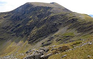
Mweelrea and the corrie lake of Lough Bellawaum, viewed from Ben Lugmore in the east
|
|
| Highest point | |
| Elevation | 814 m (2,671 ft) |
| Prominence | 779 m (2,556 ft) |
| Listing | County top (Mayo), P600, 100 Highest Irish Mountains, Marilyn, Hewitt, Arderin, Simm, Vandeleur-Lynam |
| Naming | |
| English translation | smooth bald hill |
| Language of name | Irish |
| Geography | |

Mweelrea
Location in island of Ireland
|
|
| Location | County Mayo, Ireland |
| Parent range | Mweelrea Mountains |
| OSI/OSNI grid | L7898366810 |
| Topo map | OSi Discovery 37 |
| Geology | |
| Mountain type | Sandstone & conglomerate, ignimbrite bedrock |
| Climbing | |
| Easiest route | "Silver Strand" |
| Normal route | "The Ramp" (Lug More corrie) |
Mweelrea is a tall mountain in Ireland. It stands at 814 metres (2,671 ft) high. This makes it the 26th-highest peak in Ireland on one list (the Arderin scale) and the 34th-highest on another (the Vandeleur-Lynam scale). Mweelrea is found in County Mayo, in a group of mountains called the Mweelrea Mountains. It's the highest point in the Connacht province of Ireland.
Mweelrea is known for its steep, bowl-shaped valleys called corries on its southeast side. It also offers amazing views from its top. The mountains around Mweelrea form a "horseshoe" shape. This area is located between Killary Harbour, a deep sea inlet, and Doo Lough, a lake.
Contents
What Does Mweelrea Mean?
The name Mweelrea comes from the Irish language. It is an English version of the words Irish: Cnoc Maol Réidh. This means "bald hill with the smooth top." This name perfectly describes how the mountain looks.
How Was Mweelrea Formed?
The rocks that make up Mweelrea are quite special. They are different from the rocks found in nearby mountains like the Twelve Bens. Mweelrea is mostly made of sandstones. These sandstones were formed a very long time ago, during a period called the Ordovician period.
These rocks were laid down by ancient rivers. They formed large, fan-shaped deposits called alluvial fans. Mixed in with these sandstones are layers of tuff. Tuff is a type of rock made from volcanic ash. This shows that there were volcanoes active in the area when Mweelrea was forming.
Exploring Mweelrea's Geography
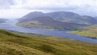
Mweelrea and its smaller peaks make up the southern part of the Mweelrea Mountains. These mountains form a horseshoe shape. To the south, you'll find Killary Harbour, which is Ireland's deepest fjord (a long, narrow sea inlet). To the north is Doo Lough, a lake.
The valley in the middle of this horseshoe shape is called Glenconnelly. At the top of this valley, below Mweelrea's southeast side, are two deep, bowl-shaped valleys called corries.
- The southern corrie holds a lake called Lough Lugaloughan.
- The northern corrie holds Lough Bellawaum.
Water from both lakes flows into the Sruhaunbunatrench River, which then joins the Bundorragha River and flows into Killary Harbour.
Mweelrea is the tallest mountain in this group. It is also the highest point in the province of Connacht. Its height and how much it stands out from the land around it (its prominence) make it a special type of mountain called a Marilyn. It's also ranked as the 16th-highest mountain in Ireland on the MountainViews Online Database.
Nearby Peaks
- Ben Bury (also known as Oughty Craggy) is northeast of Mweelrea. It is 814 metres (2,671 ft) tall.
- Ben Lugmore is further east along the horseshoe shape. It is almost as tall as Mweelrea, at 803 metres (2,635 ft). Its northeast side has a large, cliff-lined corrie called Lug More.
- The southern part of the horseshoe is lower. It includes the Mweelrea SE Spur at 495 metres (1,624 ft).
- Teevnabinnia is an isolated peak at the end of the southern arm. It is 379 metres (1,243 ft) tall. Even though it's not very high, its prominence makes it a Marilyn too.
Fun Activities on Mweelrea
Mweelrea is a popular spot for outdoor activities, especially hiking.
Hiking and Hill Walking
Since Mweelrea is the highest mountain in Connacht, it's often climbed as part of "Four Peaks Challenges." These challenges involve climbing the highest mountains in each of Ireland's four provinces.
There are a few ways to climb Mweelrea:
- The Silver Strand Route: This is the quickest way to reach the top. It's about 8 kilometers long and takes around 3 hours.
- The Lug More Corrie Route: This is a longer, 13-kilometer route that takes about 6 hours. It goes through the Lug More corrie and includes climbing Ben Bury and Ben Lugmore. There's a special path called The Ramp that helps hikers cross the corrie's steep side. It's important to find this path carefully because of the cliffs.
- The Mweelrea Horseshoe: This is a challenging 15-kilometer loop that takes 6-7 hours. It's considered one of the "top three" hikes in Ireland. This route covers all the main peaks of the Mweelrea range, including Ben Lugmore, Ben Bury, Mweelrea, and the Mweelrea SE Spur. It usually starts and ends at the Delphi Mountain Resort.
Rock Climbing
While most serious rock climbing in the Mweelrea area happens on Ben Lugmore, there are also some easier climbs on the northeastern slopes of Mweelrea and Ben Bury. These are called "scrambles" and are rated Grade 1 and 2.
Winter Climbing
In winter, when there's snow and ice, the Lough Bellawaum corrie on Mweelrea's northeast side becomes a place for winter climbing. Some well-known routes include Blue Route (Grade II/III, 270 m) and Red Route (Grade III, 305 m).
Images for kids
-
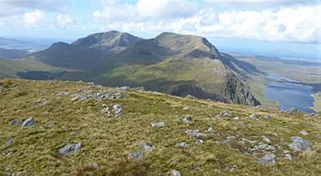
Mweelrea (back left), and Ben Lugmore (centre), viewed from the east on the summit of Ben Gorm
-
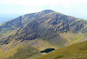
Mweelrea and the corrie lake of Lough Bellawaum, as viewed from Ben Lugmore
-
Mweelrea massif as viewed from Leenaun Hill, with Mweelrea (back left), Ben Lugmore (back, right) and Teevnabinnia (centre, front)
-
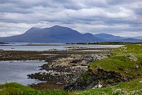
Mweelrea viewed from the south in Renvyle
-
Mweelrea eastern summit ridge as viewed from Ben Bury
,_and_Ben_Lugmore_(centre),_from_summit_of_Ben_Gorm.jpg)


See also
 In Spanish: Cnoc Maol Réidh para niños
