
Twelve Bens facts for kids
Quick facts for kids Twelve Bens (Twelve Pins) |
|
|---|---|
| Irish: Na Beanna Beola; the peaks of Beola | |
.jpg)
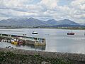
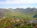
View of the range from Roundstone village.
|
|
| Highest point | |
| Peak | Benbaun |
| Elevation | 729 m (2,392 ft) |
| Dimensions | |
| Area | 161.3 km2 (62.3 sq mi) |
| Naming | |
| English translation | The peaks of Beola |
| Language of name | Irish language |
| Geography | |

Twelve Bens (Twelve Pins)
Location in Ireland
|
|
| Location | Connemara, County Galway, Ireland |
| Provinces of Ireland | Connacht |
| Topo map | OSI Discovery 37, 44 |
| Geology | |
| Age of rock | Precambrian-Cambrian |
| Type of rock | quartzites, grits, graphitic |
| Climbing | |
| Normal route |
|
The Twelve Bens or Twelve Pins (in Irish: Irish: Na Beanna Beola, meaning "the peaks of Beola") is a group of mountains in the west of Ireland. You can find them in Connemara National Park in County Galway. These mountains are known for their sharp, rocky peaks and ridges. The highest point in the range is Benbaun, which stands at 729 meters (2,392 feet) tall.
The Twelve Bens are a popular spot for outdoor activities like hiking. One famous route is the Glencoaghan Horseshoe, which is a long and exciting walk. The mountains are also connected to the Maumturks range, which is to the east. Both ranges share similar types of rocks, mostly strong quartzite.
Contents
What's in a Name?
The word "Ben" comes from the Irish word "Binn," which means "peak." So, "Twelve Bens" means "Twelve Peaks." But here's a fun fact: nobody is really sure which exact twelve peaks the name refers to! There are almost 20 peaks in the area with "Ben" or "Binn" in their names.
An Irish historian named Ruaidhrí Ó Flaithbheartaigh wrote about the "twelve high mountaines of Bennabeola" way back in 1684. Sailors used to call them "the twelve stakes" because they were the first land they saw when coming from the sea. However, he didn't list the specific twelve peaks.
Most people think the "Twelve Bens" are the main peaks in the area that are taller than 500 meters (1,640 feet). In Irish, the mountains are simply called "Na Beanna Beola," which means "the peaks of Beola." Beola was a giant and a leader from ancient Irish stories.
Exploring the Mountains

The Twelve Bens range has 22 main peaks that are over 100 meters (328 feet) tall. The tallest of these is Benbaun. To the north, there's another group of mountains called the Garraun Complex, with 9 peaks. There are also 7 other smaller peaks to the west. This means there are a total of 38 "Bens" over 100 meters!
Even though these mountains aren't as tall as some others in Ireland, their rocky tops and ridges look very impressive against the flat land around them.
The mountains are surrounded by valleys and roads. To the east is the Inagh Valley, and the R344 road. The N59 road goes around the main part of the mountains from the south, west, and north.
Main Mountain Groups
The 22 peaks in the heart of the Twelve Bens can be divided into three parts:
- Southern Bens: These 12 peaks form a horseshoe shape around the Glencoaghan Valley. They include famous peaks like Derryclare, Bencorr, and Benlettery.
- Central Bens: These 7 peaks are along a large ridge that runs from east to west, with Benbaun in the middle.
- Northern Bens: These 3 peaks are part of a smaller group, including Benbrack. Nearby is another peak called Diamond Hill.
The Twelve Bens are also famous for their deep, U-shaped valleys carved out by glaciers long ago. Many popular hiking routes follow these valleys:
- Glencoaghan: This is the most southern valley, and its "horseshoe" route is a very popular hike.
- Owenglin: A valley to the west, also known for a good hiking route.
- Gleninagh: This eastern valley has a famous spot for rock climbing called Carrot Ridge.
- Polladirk: A north-western valley that offers beautiful views from Diamond Hill.
- Glencorbet: This north-eastern valley also has a popular "horseshoe" hiking route.
Mountain Rocks and History

The main part of the Twelve Bens is made mostly of very strong rock called quartzite. You can also find softer rocks called schists in the valleys. These rocks are known as Connemara Dalradian rocks.
These rocks started as sediments (like sand and mud) that settled in a warm, shallow sea about 700 to 550 million years ago. Over millions of years, movements in the Earth's crust changed these sediments into the hard rocks we see today. The very tops of the mountains are made of tough quartzite, while the sides have schists and grey marble.
The mountains in the Garraun Complex to the north have different types of rocks, like gneiss and various kinds of sandstones and mudstones.
About 10,000 years ago, the last Ice Age also shaped the landscape. Glaciers carved out the valleys and left behind sand, gravel, and large boulders.
A Special Place for Nature
_-_geograph.org.uk_-_65980.jpg)
The entire Twelve Bens area, including the Garraun Complex, is a Special Area of Conservation (SAC). This means it's protected because it has many important habitats and species.
Some of the special habitats found here include:
- Clear, clean waters
- High mountain heaths
- Large areas of active blanket bog (a type of wetland)
- Small parts of old oak forests
- Rocky slopes
The area is also home to special animals like the Freshwater Pearl Mussel, Atlantic Salmon, and Otter. There are also some rare plants. This protection helps keep this beautiful and important natural area safe for the future.
Climbing and Hiking Adventures
The Twelve Bens are a fantastic place for people who love to hike, run on mountains, and climb rocks.
Hiking the Peaks

One writer described the Twelve Bens as "true kickass mountains, with criminally stunning views."
The Glencoaghan Horseshoe is a 16-kilometer (10-mile) hike that takes about 8-9 hours. It's known as one of the most exciting mountain walks in Ireland. There are other similar "horseshoe" routes too, like the Owenglin Horseshoe and the Glencorbet Horseshoe.
For the most adventurous, there's the Twelve Bens Challenge. This involves climbing all 12 main Bens in a single day, which is a huge undertaking!
Rock Climbing Challenges

The Twelve Bens also offer great spots for rock climbing. The most famous is Carrot Ridge in the Gleann Eighneach valley. Climbs here can be from 150 to 320 meters long, with different difficulty levels.
There are also other climbing areas in the large bowl-shaped valleys (called corries) between the peaks. These offer multi-pitch climbs, where climbers go up in sections, sometimes hundreds of meters high.
List of Main Peaks
While there are many peaks in the wider Twelve Bens area, here are the 12 peaks most commonly thought of as the original "Twelve Bens." These are the main peaks in the core mountain range that are over 500 meters (1,640 feet) tall.
| Name | Irish Name | Meaning | Height (m) | Height (ft) |
|---|---|---|---|---|
| Benbaun | Binn Bhán | White Peak | 729 | 2,392 |
| Bencorr | Binn Chorr | Pointed Peak | 711 | 2,333 |
| Bencollaghduff | Binn Dubh | Black Peak | 696 | 2,283 |
| Benbreen | Binn Braoin | Braon's Peak | 691 | 2,267 |
| Derryclare | Binn Doire Chláir | Peak of Derryclare | 677 | 2,221 |
| Bengower | Binn Gabhar | Goats' Peak | 664 | 2,178 |
| Muckanaght | Muiceanach | Hill like a Pig | 654 | 2,146 |
| Benfree | Binn Fraoigh | Peak of the Heather | 638 | 2,093 |
| Bencullagh | An Chailleach | [Peak of] The Hag/Witch | 632 | 2,073 |
| Benbrack | Binn Bhreac | Speckled Peak | 582 | 1,909 |
| Benlettery | Binn Leitrí | Peak of the Wet Hillsides | 577 | 1,893 |
| Benglenisky | Binn Ghleann Uisce | Peak of the Glen of Water | 516 | 1,693 |
Images for kids
-
View of the range from Roundstone village.
-
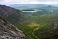
Glencoaghan River from Bencullaghduff
-
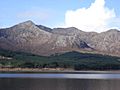
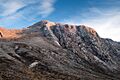
Quartzite peaks and rocky ridges of Bencorr and its subsidiary peaks and spurs
-
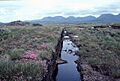
The range includes extensive bog habitats
-
View of Polladirk Valley from Diamond Hill.
-
Carrot Ridge in the Gleninagh Valley
See also
 In Spanish: Twelve Bens para niños
