
Benbaun facts for kids
Quick facts for kids Benbaun |
|
|---|---|
| Binn Bhán | |

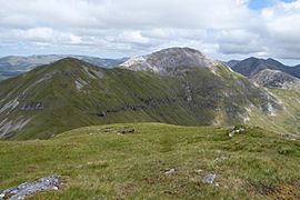
Summit and south face of Benbaun, as viewed from Bencollaghduff; Muckanaght is back left
|
|
| Highest point | |
| Elevation | 729 m (2,392 ft) |
| Prominence | 684 m (2,244 ft) |
| Listing | P600, County top (Galway), 100 Highest Irish Mountains, Marilyn, Hewitt, Arderin, Simm, Vandeleur-Lynam |
| Naming | |
| English translation | white mountain |
| Language of name | Irish |
| Geography | |

Benbaun
Location in island of Ireland
|
|
| Location | Galway, Republic of Ireland |
| Parent range | Twelve Bens |
| OSI/OSNI grid | L7855853903 |
| Topo map | OSi Discovery 37 |
| Geology | |
| Type of rock | Pale quartzites, grits, graphitic Bedrock |
Benbaun (Irish: Binn Bhán, meaning white peak) is a tall mountain in Ireland. It stands at 729 metres (2,392 ft) high. Benbaun is special because it's the tallest mountain in the Twelve Bens range. It is also the highest point in Galway. You can find it right in the middle of the Twelve Bens mountains, inside the beautiful Connemara National Park in Ireland.
Contents
What's in a Name?
The name "Benbaun" comes from the Irish language. It means "white peak." This name fits perfectly because the top of the mountain has a lot of white quartzite rock. It's so white that some people call it the "Mont Blanc" of Connemara.
Where is Benbaun?
Benbaun is the highest mountain in the Twelve Bens range. This mountain range is located in the Connemara National Park in western Galway. Benbaun sits in the center of a long ridge that stretches from east to west.
Nearby Peaks
To the west of Benbaun, you'll find other important mountains. These include Benfree (Irish: Binn Fraoigh, meaning peak of the heather) at 638 metres (2,093 ft). There's also Muckanaght (Irish: Muiceanach, meaning hill like a pig) at 654 metres (2,146 ft). And Bencullagh (Irish: An Chailleach, meaning peak of the hag/witch) stands at 632 metres (2,073 ft).
To the east, there's a long, flat ridge about 3.5 kilometers long. At the very end of this ridge is a smaller mountain called Knockpasheemore (Irish: Binn Charrach, meaning rocky peak) at 412 metres (1,352 ft).
Valleys and Connections
Benbaun is surrounded by deep valleys. To the south, a low pass called Maumina connects Benbaun to Bencollaghduff (696 metres (2,283 ft)). This area is part of the "Glencoaghan Horseshoe," a famous hiking route.
To the north, another deep pass connects Benfree and Muckanaght to Benbrack (582 metres (1,909 ft)).
Benbaun is also at the top of two large valleys shaped by glaciers. To the east is the Gleninagh Valley. From here, the Gleninagh river flows. To the southwest is the big valley of the Owenglin river.
Hiking Benbaun
Climbing Benbaun can be a great adventure. One common way to reach the top is by walking up the Gleninagh valley. Another way is to first climb Knockpasheemore and then walk along the 3.5-kilometer ridge to Benbaun's summit. Both routes take about 4 to 5 hours of walking and cover over 9 kilometers.
Even though Benbaun is the tallest mountain in the Twelve Bens, it gets fewer visitors than some other peaks. This is because it's a bit off the main path of the very popular 16-kilometer "Glencoaghan Horseshoe" hike.
Other Hiking Routes
Benbaun is also part of other challenging "horseshoe climbs" in the area:
- Owenglin Horseshoe: This is a long 20-kilometer route. It takes about 10 to 12 hours to complete. This route goes around the Owenglin River and includes more than twelve mountain tops.
- Gleninagh Horseshoe: This route is about 15 kilometers long and takes 8 to 9 hours. It usually starts at Knockpasheemore and ends at Bencorrbeg.
- Glencorbet Horseshoe: This is a 14-kilometer circuit around the Kylemore River. It typically takes 6 to 7 hours. This route often starts at a smaller peak also named Benbaun (at 477 meters) and finishes at Knockpasheemore.
Images for kids
-
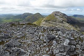
(l-to-r) Bencullagh, Muckanaght and Benbaun, viewed from Bencollaghduff
-
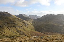
Intersection of Benbaun, Bencollaghduff and Benbreen, viewed from Muckanaght
-
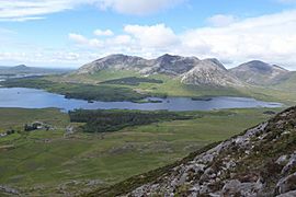
(l-to-r) Derryclare, Bencorr, and Benbaun, viewed from Letterbreckaun
-
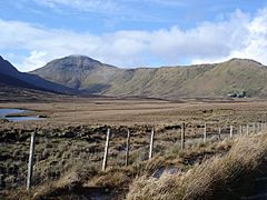
Benbaun (left) and the long easterly ridge to Knockpasheemore (right)
-
Benfree (left) and Benbaun (right), viewed from summit of Muckanaght

.jpg)


See also
 In Spanish: Binn Bhán para niños
