
Derryclare facts for kids
Quick facts for kids Derryclare |
|
|---|---|
| Binn Doire Chláir | |

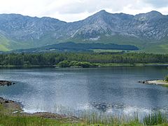
Derryclare, behind Derryclare Lough
|
|
| Highest point | |
| Elevation | 677 m (2,221 ft) |
| Prominence | 129 m (423 ft) |
| Listing | 100 Highest Irish Mountains, Hewitt, Arderin, Simm, Vandeleur-Lynam |
| Naming | |
| English translation | peak of Derryclare [townland] / peak of the oak-wood of the plain |
| Language of name | Irish |
| Geography | |

Derryclare
Location in Ireland
|
|
| Location | Galway, Ireland |
| Parent range | Twelve Bens |
| OSI/OSNI grid | L8150951048 |
| Topo map | OSi Discovery 37 |
| Geology | |
| Type of rock | Pale quartzites, grits, graphitic Bedrock |
Derryclare (Irish: Binn Doire Chláir, meaning peak of Derryclare/peak of the oak-wood of the plain) is a mountain in Ireland. It stands 677 meters (about 2,221 feet) tall. This makes it one of the highest peaks in Ireland.
Derryclare is located in the beautiful Connemara National Park in Galway, Ireland. It is part of the Twelve Bens mountain range. In fact, it is the 5th tallest mountain among the main Twelve Bens.
On its southern side, you'll find the lovely Derryclare Lough (a lake). On its eastern side, there's Derryclare Wood, which is a special nature reserve.
Contents
What's in a Name?
The name "Derryclare" comes from the Irish language. It was likely named after a nearby area called Derryclare.
- The Irish word Doire means a wood, often an oak wood.
- The word clár can mean a "plain" or a "board/plank-bridge."
So, Binn Doire Chláir could mean "peak of the oak-wood at the plain or bridge." This makes sense because Derryclare Wood is near the mountain, and it's surrounded by lakes.
Where is Derryclare?
Derryclare is one of the mountains farthest south in the Twelve Bens range. It sits at the eastern entrance of a large U-shaped valley called the Glencoaghan River valley.
- To the south of Derryclare is the beautiful Derryclare Lough.
- To the east are the large Inagh Valley and Lough Inagh.
Derryclare's closest mountain neighbor is Bencorr, which is 711 meters (about 2,333 feet) tall. Bencorr is the second-highest peak in the Twelve Bens. These two mountains are connected by a high, rocky ridge to the north.
Together, Derryclare and Bencorr form a big, deep, bowl-shaped valley called a corrie. In Irish, this corrie is known as Irish: Log an Choire Mhóir, which means "wood of the big corrie."
This corrie leads down to the Derryclare Wood. This wood includes:
- A 19-hectare (about 47-acre) broadleaf forest that is a special nature reserve.
- A much larger 789-hectare (about 1,950-acre) commercial conifer forest. Both parts of the wood are next to Derryclare Lough and Lough Inagh.
Derryclare Nature Reserve
In 1980, the Irish government set aside 19 hectares of woodland on the eastern slopes of Derryclare as a special protected area. This is called the Derryclare Nature Reserve. Some people also call it Derryclare Wood.
This reserve is home to many different kinds of broadleaf trees. The main trees are Sessile Oak, with Rowan and Downy Birch. You can also find some Ash trees. These trees create a thick layer of leaves above, called a canopy. The reserve also has many interesting lichens and fungi.
Did you know? A type of fungus called Hemigrapha astericus, which usually grows in Australia and South America, was first found in the northern part of the world right here in Derryclare Wood!
In 2005, something special happened. 19 red squirrels were moved from Portumna Forest Park to Derryclare Wood. This was part of a plan to help protect these squirrels in Ireland.
Hiking on Derryclare
Derryclare is one of the easier mountains to reach in the Twelve Bens. It's close to the N59 road. There are several paths you can take to climb to the top and back down. You can start from the Glencoaghan Valley on the west side or from the Derryclare Nature Reserve on the east side.
Many hikers enjoy "horseshoe" walks around Derryclare. These are circular routes that take you up and over several peaks. For example, you can do an 11–14 kilometer (about 7–9 mile) walk that takes 5–7 hours. This walk often includes Bencorr.
Derryclare is also part of a very popular and challenging hike called the Glencoaghan Horseshoe. This walk is about 16 kilometers (10 miles) long and takes 8–9 hours. It's considered one of the best hill-walks in Ireland!
Rock Climbing
The big, bowl-shaped valley (corrie) between Derryclare and Bencorr is called Irish: Log an Choire Mhóir. This corrie is a great spot for rock climbing. It has several tall climbs, some as high as 200 meters (about 650 feet). These climbs have different difficulty levels. One famous climb there is called The Knave.
Gallery
-
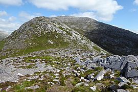
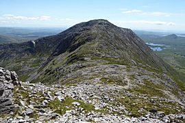
Summit of Derryclare from south-ridge
-
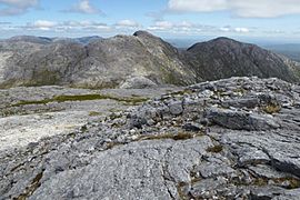
Bencorr (center) and Derryclare (right), from Bencollaghduff
-
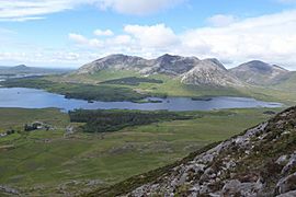
Derryclare (left), Bencorr (centre), Bencorr North Top (right); Benbaun is far right
-
Derryclare (left), Bencorr (centre), and Bencorr North Top (right); with the corries of Log an Choire Mhóir (left) and Log an Choire Bhig (right)
-
Looking south to the summit of Derryclare from its northern-ridge with Bencorr


