
Bencorr facts for kids
Quick facts for kids Bencorr |
|
|---|---|
| Binn Chorr | |

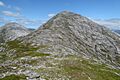
Bencorr (left) and its subsidiary peaks, and two easterly spurs, from across Lough Inagh.
|
|
| Highest point | |
| Elevation | 711 m (2,333 ft) |
| Prominence | 306 m (1,004 ft) |
| Listing | 100 Highest Irish Mountains, Marilyn, Hewitt, Arderin, Simm, Vandeleur-Lynam |
| Naming | |
| English translation | pointed peak |
| Language of name | Irish |
| Geography | |

Bencorr
Location in Ireland
|
|
| Location | Galway, Ireland |
| Parent range | Twelve Bens |
| OSI/OSNI grid | L8116652200 |
| Topo map | OSi Discovery 37 |
| Geology | |
| Type of rock | Pale quartzites, grits, graphitic top bedrock |
Bencorr (Irish: Binn Chorr, meaning Pointed Peak) is a mountain in Ireland. It stands at 711 metres (2,333 feet) tall. This makes it one of the highest peaks in the country.
Bencorr is located in the Twelve Bens mountain range. This range is found in the Connemara National Park in Galway, Ireland. It is the second-tallest mountain in the Twelve Bens. Only Benbaun (729 metres) is taller. Bencorr is very close to Benbaun.
Contents
What's in a Name?
The name Bencorr means "Pointed Peak" in the Irish language. This name describes its shape well.
Long ago, in the 1830s, mapmakers from the British army set up a special beacon on Bencorr. This was to help them create the first detailed maps of Ireland. There's a story that a smaller peak nearby, called Binn an tSaighdiúra, which means "soldier's peak," was named after one of these soldiers. Sadly, the story says he fell from the mountain.
Mountain Features
Bencorr has a unique shape. It looks like it has two tops when you see it from far away. This is because of a short, rocky ridge that connects it to another peak called Bencorr North Top, which is 690 metres (2,264 feet) high.
One of Bencorr's most famous features is its long, rocky ridge on the northeast side. This is known as Carrot Ridge (or Meacan Buí in Irish). Along this ridge are two smaller peaks: Binn an tSaighdiúra (653 metres / 2,142 feet) and Bencorrbeg (577 metres / 1,893 feet).
Valleys and Corries
Bencorr sits where two large valleys meet. These valleys were carved out by glaciers long ago. To the northeast is the Gleninagh Valley, known for its ivy. To the west is the Glencoaghan River valley.
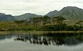
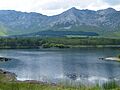
Bencorr also has two bowl-shaped hollows on its eastern side. These are called corries. The larger one is called Log an Choire Mhóir, meaning "wood of the big corrie." The smaller one is Log an Choire Bhig, meaning "wood of the small corrie." Both of these corries lead down towards Derryclare Wood and Lough Inagh, a beautiful lake.
Bencorr is considered a "Marilyn" mountain. This means it stands out a lot from the land around it. It has a "prominence" of 306 metres (1,004 feet). This measurement shows how much higher a mountain's summit is than the lowest point connecting it to a higher peak.
Exploring Bencorr
Bencorr is a popular mountain for hill walking and climbing.
Walking Routes
There are several ways to climb Bencorr. A straightforward path takes you through the Gleninagh valley. Another option is to first climb Bencorrbeg and then walk along Carrot Ridge to the summit. Both of these routes usually take about 4 to 5 hours to complete.
Many hikers enjoy longer, more challenging routes that include Bencorr. One popular choice is the "Glencoaghan Horseshoe." This is a 16-kilometre (10-mile) route that takes about 8 to 9 hours. It is known as one of the best ridge walks in Ireland. Another great option is the "Gleninagh Horseshoe," which is a 15-kilometre (9-mile) route around the Gleninagh River.
Rock Climbing

Carrot Ridge, the rocky spur on Bencorr's northeast side, is a famous place for rock climbing in Connemara. It offers many different climbing routes. Some routes are easier, while others are very challenging. They can be from 150 to 320 metres (490 to 1,050 feet) long. Classic climbs here include "Carrot Ridge" and "Seventh Heaven."
Climbers have been tackling Carrot Ridge since at least 1933. The name "Carrot Ridge" was given by an Irish climber named Joss Lynam in 1949. He thought he was the first to climb it, but others had been there before him!
The large corrie called Log an Choire Mhóir also has several long rock climbs. The smaller corrie, Log an Choire Bhig, has shorter but tougher climbs.
Images for kids
-
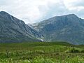
Carrot Ridge, with Bencorrbeg (left), and Binn an tSaighdiúra and Bencorr N Top (right)
-
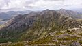
View from Benbaun to Bencollaghduff (center), and ridge to Bencorr and Derryclare behind
-
View into Glencaghan and summits of (right-to-left) Derryclare, Bencorr, and Bencollaghduff
-
Lough Inagh, Derryclare (left), Bencorr (center), Bencorr N Top (right)
-
Bencorr (center), with Bencollaghduff (back left), from Derryclare


_and_Bencorr_(right)_from_north_col_of_Derryclare.jpg)
