
Lough Inagh facts for kids
Quick facts for kids Lough Inagh |
|
|---|---|

Bencorr and Bencorr North Top, with its two easterly spurs, from Lough Inagh
|
|

Lough Inagh
Location in Ireland
|
|
| Location | County Galway, Ireland |
| Coordinates | 53°30′55″N 9°44′29″W / 53.515304°N 9.741515°W |
| Native name | Loch Eidhneach Error {{native name checker}}: parameter value is malformed (help) |
| Primary inflows | Tooreennacoona River Gleninagh River |
| Primary outflows | Derryclare Lough |
| Basin countries | Ireland |
| Surface area | 3.1 km2 (1.2 sq mi) |
| Surface elevation | 21 m (69 ft) |
| Islands | Deer Island, Illauninagh, Eagle Islands, Red Island, Crow's Island, Otter Island, Man's Island, Lue Island |
Lough Inagh is a beautiful freshwater lake in the west of Ireland. Its name, Loch Eidhneach, means "lake of the place of ivy" in Irish. It is located in the stunning Inagh Valley in Connemara, Galway.
Contents
Exploring Lough Inagh's Surroundings
Lough Inagh is found in the Inagh Valley, about 23 kilometers east of Clifden. You can reach it by the R344 road.
Mountains Around the Lake
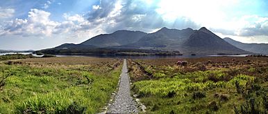
Tall mountains surround the lake. To the west, you'll see the Twelve Bens mountain range. Two peaks, Derryclare (677 meters) and Bencorr (711 meters), stand right over the lake.
To the east, the Maumturks mountain range stretches out. Its highest peaks, Letterbreckaun (677 meters) and Binn idir an Dá Log (702 meters), also overlook Lough Inagh.
Water Flow and Rivers
Lough Inagh gets its water from several mountain streams. The most important ones are the Gleninagh River and the Tooreennacoona River. The Gleninagh River starts high up in the Gleninagh Valley.
After filling Lough Inagh, the water flows into Derryclare Lough. From there, it goes into Ballynahinch Lake. Finally, it joins the Owenmore River and flows into Bertraghboy Bay.
Fishing Adventures at Lough Inagh
Lough Inagh is a famous spot for fishing. You can catch different types of salmon and sea trout here. The best way to fish is from a boat. Since the lake is quite big, an outboard motor is helpful for getting around. Just be careful of a few hidden rocks!
The fishing rights for Lough Inagh are privately owned. Local fishing lodges in the Inagh Valley manage them. A well-known Irish fishing author, Peter O'Reilly, once said that Lough Inagh is so good, it "will take more than one day to explore adequately."
Amazing Views and Nature
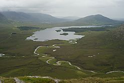
Lough Inagh is a very popular place for its beautiful scenery.
Views of the Twelve Bens
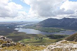
Looking west from the lake, you can see large, deep valleys called corries. One big corrie is between Derryclare and Bencorr. Its Irish name, Log an Choire Mhóir, means "wood of the big corrie". There's also a smaller corrie between Bencorr and Bencorr North Top. This one is called Log an Choire Bhig, meaning "wood of the small corrie".
At the bottom of these corries, where they meet the lake, you'll find Derryclare Wood and the Derryclare Nature Reserve. These are lovely natural areas to explore.
The Gleninagh Valley
At the northern end of the lake, near Bencorrbeg (577 meters), you can see into the Gleninagh Valley. This valley, Gleann Eidhneach in Irish, is where the lake gets its name. On one side of the valley is the impressive Carrot Ridge, a popular spot for rock climbing. At the very end of the valley are Bencollaghduff (696 meters) and Benbaun (729 meters). Benbaun is the highest peak in the entire Twelve Bens range!
Gallery
-

Lough Inagh from slopes of Letterbreckaun, with Derryclare (left), Bencorr (center), and Benbaun (right)
-

Derryclare (left), Bencorr (center), Bencorr North Top (right), and two Log an Choire corries
-
Lough Inagh and the Twelve Bens, viewed from the Maumturks
-
Lough Inagh and Lissoughter (back, right), viewed from Knockpasheemore
-
Looking west over Lough Inagh to Derryclare and Bencorr–Bencorr North Top, and the two Log an Choire corries


