
Letterbreckaun facts for kids
Quick facts for kids Letterbreckaun |
|
|---|---|
| Binn Bhriocáin | |

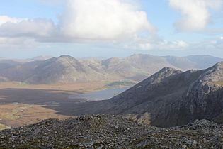
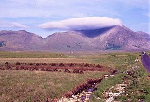
West face of Letterbreckaun, Inagh Valley
|
|
| Highest point | |
| Elevation | 667 m (2,188 ft) |
| Prominence | 322 m (1,056 ft) |
| Listing | 100 Highest Irish Mountains, Marilyn, Hewitt, Arderin, Simm, Vandeleur-Lynam |
| Naming | |
| English translation | Brecan's peak |
| Language of name | Irish |
| Geography | |

Letterbreckaun
Location in island of Ireland
|
|
| Location | Galway, Ireland |
| Parent range | Maumturks |
| OSI/OSNI grid | L8565255093 |
| Topo map | OSi Discovery 37 |
| Geology | |
| Type of rock | Pale quartzites, grits, graphitic top bedrock |
| Climbing | |
| Easiest route | Via pass of Maumahoge or the pass of Maam Turk |
Letterbreckaun (Irish: Binn Bhriocáin, meaning Brecan's peak) is a mountain in Ireland. It stands at 677 metres (2,221 feet) tall. This makes it one of the highest peaks in the country. Letterbreckaun is located in the middle part of the Maumturks mountain range. You can find it in the Connemara National Park in Galway, Ireland. It is the second tallest mountain in the Maumturks range.
Contents
What's in a Name?
The name "Letterbreckaun" comes from the Irish words Leitir Bhriocáin. This means "Brecan’s wet hillside." It's also the name of a small area of land on the mountain's side. Saint Brecan is a saint linked to Galway county. People say he was the person who followed Saint Enda of Aran.
Mountain Geography
Letterbreckaun is found at the northern end of the central part of the Maumturks range. This range stretches from the northwest to the southeast. When you look at Letterbreckaun from the west, it has a special "pyramid" shape. This is different from the rounder mountains nearby.
Connecting Peaks
To the south, Letterbreckaun is connected to Knocknahillion. This mountain is 607 metres (1,991 feet) high. They are linked by a long, winding ridge made of quartzite rock. This ridge includes two smaller peaks: Barrlugrevagh (558 metres / 1,831 feet) and Knocknahillion North Top (541 metres / 1,775 feet). After Knocknahillion, the ridge goes down to a low point called a "col." This col is named Maumahoge (Irish: Mhám Ochóige). A col is like a saddle between two peaks.
North of Letterbreckaun is a smaller peak called Letterbreckaun NE Top. It is 603 metres (1,978 feet) tall. This peak stands out enough to be called an Arderin Beg. Further north, the slopes of Letterbreckaun drop steeply into a sharp, "v-shaped" col. This col is called Maam Turk (Irish: Mám Tuirc). Its name means "pass of the boar." The entire Maumturks mountain range gets its name from this pass.
Maam Turk Pass
An Irish historian named Ruaidhrí Ó Flaithbheartaigh wrote about a "holy well" at Maam Turk in 1684. He said it was "in memory of St. Fechin." North of the Maam Turk col is a smaller peak called Maumturkmore. After that, you cross a spot known as the "Col of Despondency." Then you reach the grassy hills of Leenaun Hill, which are made of sandstone and siltstone.
How Much It Stands Out
Letterbreckaun has a "prominence" of 322 metres (1,056 feet). Prominence means how much a mountain rises above the low points around it. This high prominence makes it a Marilyn. A Marilyn is a mountain that stands out a lot from its surroundings. It also ranks as the 82nd-highest mountain in Ireland on the MountainViews Online Database. This list includes mountains that have a prominence of at least 100 metres.
Hill Walking Adventures
There are a few ways to reach the top of Letterbreckaun.
Easier Route
The easiest way to climb Letterbreckaun is a 6-kilometre (3.7-mile) route. It takes about 2 to 3 hours and goes through the pass of Maam Turk.
Longer Loop Route
Because Letterbreckaun is on the high, rocky central ridge of the Maumturks, many people climb it as part of a longer trip. This is a 14-kilometre (8.7-mile) loop that takes 5 to 6 hours. It starts at the col of Maumahoge in the south. Hikers first climb Knocknahillion. Then they follow a winding 2-kilometre (1.2-mile) rocky ridge to the top of Letterbreckaun. Finally, they go down through the "v-shaped" col of Maam Turk.
The Maamturks Challenge
Letterbreckaun is also part of the Maamturks Challenge. This is a very long walk, about 25 kilometres (15.5 miles) long. It takes 10 to 12 hours to complete. The challenge goes over the entire Maumturks range, from Maam Cross to Leenaun. It's known as one of the "great classic ridge-walks of Ireland." However, it's considered "extreme" because you climb about 7,600 feet in total.
Since 1975, the University College Galway Mountaineering Club has held an annual "Maamturks Challenge Walk" (MCW). They even have a checkpoint on the summit of Letterbreckaun during this event.
Images for kids
-
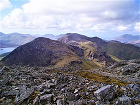
Letterbreckaun (centre, distance) viewed from Benbaun
-
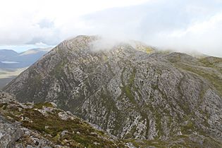
South face of Letterbreckaun from ridge with Knocknahillion
-
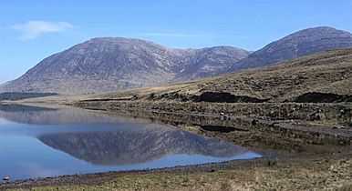
Looking north to Letterbreckaun (left), and Knocknahillion (right), across Lough Inagh
-
Letterbreckaun behind Knocknahillion, viewed from Binn idir an dá Log
-
Letterbreckaun (right, in cloud) with the v-shaped pass of Maam Turk (left)


_and_Knocknahillion_(right)_from_Inagh_Valley.jpg)

.jpg)
