
Knocknahillion facts for kids
Quick facts for kids Knocknahillion |
|
|---|---|
| Cnoc na hUilleann | |

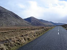
Knocknahillion, viewed from Binn idir an dá Log; behind is the summit of Letterbreckaun
|
|
| Highest point | |
| Elevation | 607 m (1,991 ft) |
| Prominence | 152 m (499 ft) |
| Listing | Marilyn, Hewitt, Arderin, Simm, Vandeleur-Lynam |
| Naming | |
| English translation | peak of the west elbow |
| Language of name | Irish |
| Geography | |

Knocknahillion
Location in island of Ireland
|
|
| Location | County Galway, Republic of Ireland |
| Parent range | Maumturks |
| OSI/OSNI grid | L8703653756 |
| Topo map | OSi Discovery 37 |
| Geology | |
| Type of rock | Pale quartzites, grits, graphitic top bedrock |
| Climbing | |
| Easiest route | Via pass of Maumahoge |
Knocknahillion (Irish: Cnoc na hUilleann, meaning peak of the west elbow) is a mountain in County Galway, Ireland. It stands at 607 meters (about 1,991 feet) tall. This makes it one of the higher peaks in Ireland.
Knocknahillion is part of the Maumturks mountain range. This range is located in the Connemara National Park. The mountain is known for its western slopes. They have a cool "diagonal" rock pattern when you look at them from the Inagh Valley.
What's in a Name?
The name Knocknahillion comes from the Irish words Cnoc na hUilleann Thair. This means "peak of the west elbow."
This name makes a lot of sense for a few reasons. First, the mountain is located to the west of the main ridge of the Maumturks range. Second, the mountain range itself makes a turn here. It's like an "elbow" in the mountains.
Where is Knocknahillion?
Knocknahillion is right in the middle of the Maumturks mountain range. This range stretches from the northwest to the southeast. It's all within the beautiful Connemara National Park.
To the north, Knocknahillion is connected to Letterbreckaun. Letterbreckaun is the second highest peak in the Maumturks. A winding, rocky ridge connects these two mountains. Along this ridge, you'll find two smaller peaks. One is Knocknahillion North Top, which is 541 meters tall. The other is Barrlugrevagh, at 558 meters.
To the southeast of Knocknahillion, there's a low point called Maumahoge. After this low point, the land rises again. You'll find a lake called Lough Maumahoge there. This lake sits in a bowl-shaped valley. Eventually, the land climbs to Binn idir an dá Log. This is the highest mountain in the Maumturks range.
Hiking Up Knocknahillion
Climbing Knocknahillion is a popular activity for hikers. The easiest way to reach the top is a route through the Maumahoge pass. This hike is about 5 kilometers long and takes 2 to 3 hours.
Many hikers also choose a longer route. This route is a 14-kilometer loop that takes 5 to 6 hours. It starts at Maumahoge. You climb Knocknahillion first. Then, you follow a rocky ridge for 2 kilometers to the top of Letterbreckaun. After that, you descend through a sharp, V-shaped pass called Maam Turk. This pass is very famous. The entire Maumturks range gets its name from it!
Knocknahillion is also part of a big hiking event called the Maamturks Challenge. This is a very long walk, about 25 kilometers. It takes 10 to 12 hours to complete. Hikers walk over the entire Maumturks range, from Maam Cross to Leenaun. It's known as one of Ireland's "great classic ridge-walks." It's considered very difficult because of the huge amount of climbing involved. However, because Knocknahillion is a bit off the main ridge, hikers don't always climb its summit during the challenge.
Rock Climbing
The Maumturks range isn't super famous for rock climbing. Other mountains, like Bencorr, are more well-known for their climbing routes. However, some climbing routes have been set up near Lough Maumahoge. These routes are between 90 and 190 meters long. They have different difficulty levels, from S to HVS.
Gallery
-
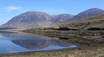
Looking north to Letterbreckaun (left), and Knocknahillion (right), across Lough Inagh
-
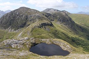
Lough Maumahoge, Knocknahillion (left) and the ridge to Letterbreckaun
-
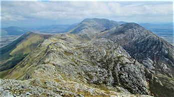
Letterbreckaun to Knockhillion ridge (middle, right), with Binn idir an dá Log (centre, back)
-
Looking north to Knocknahillion (left), and Letterbreckaun (middle)
-
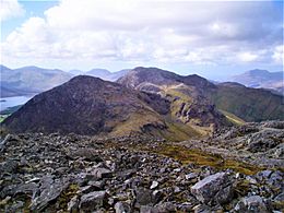
Maumturks range from the Inagh Valley, with Knocknahillion (centre)
_and_Knocknahillion_(right)_from_Inagh_Valley.jpg)


